
No, it’s not a rocket.
An Israeli television station has published a number of satellite images of a launch pad at the Imam Khomeini Space Center near Semnan in Iran that purport to show a new Iranian missile.
One problem: It’s not a rocket.
A simple understanding of how the launch pad works quickly demonstrates that the object in the image cannot be a missile. It is an architectural element on the gantry, possibly an elevator.
I love satellite photographs, but you have to interpret them in context. It’s important to model the whole facility and understand how it operates. Otherwise, you make big mistakes.
If you want to watch the original Israeli newscast, it is here.
Norbert Brügge also has copies of the images. The darkish thing does sort of look rocket-ish, I suppose.
The layout of the Iranian launch pad in question, which remains under construction, is very similar to the Satish Dhawan Space Center in Sriharikota, India. Here is a comparison of satellite images of the two sites located at 13°43’59.33″N, 80°14’5.31″E (India) and 35°14’11.90″N, 53°57’1.73″E (Iran).

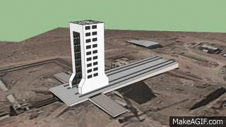
For a launch, the rocket is positioned over the flame bucket, next to an umbilical tower. Once the rocket is assembled, the gantry retracts along rails. This arrangement is the same at Semnan in Iran and Satish Dhawan in India. My colleagues at the James Martin Center for Nonproliferation Studies, Melissa Hanham and Dave Schmerler, created a little gif showing the normal operation of the Semnan launch pad in question with a rocket in the correct location. (It’s nice having such capable colleagues.)
CNS produced a whole video on the Imam Khomeini Space Center for NTI in case you are interested.
Obviously, the object in the Israeli TV picture can’t be a rocket. It’s on the wrong side of the gantry. The “rocket” would have to mysteriously travel through back wall of the gantry and then around the umbilical tower to reach the launch point. An Iranian ICBM isn’t half as impressive as a missile that can pass through walls and steel lattice-work. Here is a comparison using one of the Israeli satellite images of Semnan and a ground-truth picture from the Indian launch site that explains the problem.

Just to sure, we looked at construction photos to confirm that, yes, the back side of the gantry is closed. I found the image on the left; RAJ47 provided the other one.

So, clearly, it’s not a rocket. What is it? Tal Inbar figures it is probably an elevator. I am wishing for a bas-relief rocket in boost, but am not getting my hopes up. Someone will buy a new satellite photograph of the backside of the gantry sooner or later and we’ll get a better look. But it’s not a rocket.
There is still the issue of the NOTAM. That’s interesting, but more on that in a bit.

The square top of the unidentified tower and the flat top shadow it casts are clear signatures this is not a rocket. Also the body of the tower is not smooth and the tonal color is wrong.
It is most likely a stabilizing tower to be used in a future launch.
— imagery Analyst
Imagery analysis by iPhone. Neither Bud Wheelon nor Steve Jobs could have predicted this. #GEOINT
I did not catch the audio, I presume the bald guy is some expert? Who can’t ID the flame trench to the left as the place where the rocket goes? One thing that stood out to me was the wide radius of curvature turning quadrant for maneuvering missiles to and from the pad. Either that or the Iranians want to maintain a good 60 MPH/100 km/hr when making the turn to a different road. Who wouldn’t?
Could the unknown object be something used in handling liquid propellants?
I think he’s a reporter. You know who would have been a great expert to call? Tal Inbar, that’s who.
Ah, but it shows that the Iranians have the “intention to obtain the capability” to launch rockets so everyone panic anyway.
I don’t think the TV that produced the report is interested in facts. The whole program did not bother to mention that the place in question is a space port and missiles launched from them are used for satellite launch.
Furthermore, why is this so important? Iran has had the launch capability since 2009. Why suddenly everyone is trying to pretend a new treat has appeared?
If it were a rocket, the issue would be it’s size — and, therefore, range. But, of course, it isn’t a rocket at all.
Any ideas about what the secured area in the hills 2.5 km north of the pad (35.259 N, 53.954 E) is? It appears to have a flame trench, so perhaps engine testing?
Allen, the site you are referring to is a static test stand for rocket engines.
Thanks much. Is there any imagery analysis of it available? In particular, is it possible to say anything about the largest/most powerful engines that could be tested there?
Allen,
It is hard to tell from the available photos what is the most powerfull enginge that could be tested at the site.
It is a test stand for liquid fueled engines – and from the soze of it I can asume a large engine – and cluster of engines – could be tested.
At least in the class of Unha and probably evan larger.
Tale a look at the new pictures taken by a European satellite:
http://www.janes.com/article/48479/analysis-iranian-icbm-claim-falls-short-of-the-mark
The satellite has now been launched.
Fajr (Dawn) – 52 kg
Imaging payload
450 km orbit
Safir-Fajr SLV
Length 21-meter
Mass 26 tons
Video: https://www.youtube.com/watch?v=7xzt5V8buqM
Orbital inclination is 55.54 degrees which, if I did the arithmetic correctly, indicates a launch azimuth of 42 degrees, taking it over Turkmenistan somewhat west of Ashgabat.
The rocket is shown being erected from its transporter at :35 in the video.
The other launch site being discussed above is not related to this launch.
The video is the Israeli News TV from the post:
https://www.youtube.com/watch?v=7xzt5V8buqM
Not the Iranian TV video.
The _ correct _ Israeli Newscast URL:
https://www.youtube.com/watch?v=xs_qeK3wMBY
The launch pad and transporter (with rocket?) is at :35
Ignore the other reply.
It will be interesting to know what happens at the facility in the satellite photos will launch in the future (if anything). The most recent satellite launch (carrying the Fajr satellite) used a TEL. Interestingly, unlike in the past, the Safir SLV’s TEL was a “borrowed” military TEL (camouflaged in tan) instead of the more ‘civilian’ looking white TEL. Wonder if this has anything to do with the reported failed launches?
People who don’t want to admit that the current nuclear modernization plan is impossible like to imply that my estimates are somehow off. That’s what I don’t make my own estimates. I am simply curating the estimates by the Department of Defense, the services, or independent government entities like Government Accountability Office or Congressional Budget Office. (Go ahead, click on the links.) When you put the plans next to one another, it is immediately clear there isn’t enough money
Spelling correction need here?
“That’s *why* I don’t…”
or
“That’s what I don’t do: make my own estimates.”