During my panel at the Wilson Center, David Albright told a story about how the Israelis talked to Gernot Zippe — inventor of the Zippe-centrifuge — about the contacts that some German scientists and firms had in Egypt.
I wanted to shout “Hey, that’s the opening to The Odessa File!”
So, with my admission of really enjoying Frederick Forsyth’s novels, I readily admit that the phrase “Egypt’s ballistic missile test and launch facility” gets my attention.
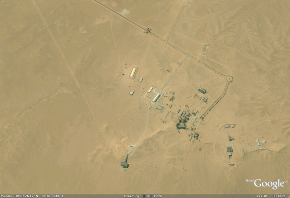
Joseph Bermudez has an interesting examination of just that facility, near Jabal Hamzah, in the most recent Jane’s Intelligence Review, (Pyramid scheme: Egypt’s ballistic missile test and launch facility, February 4, 2010.) It is subscription-only, but you can look at the images in Google Earth. Here is the key graf:
Since 2000, satellite imagery has revealed significant and continuing infrastructure expansion at the Jabal Hamzah facility.
The missile facility is located in the governorate of Al Jizah (Giza). While the national designator is presently uncertain, in the late 1960s the US Central Intelligence Agency designated it the Jabal Hamzi Surface-to-Surface Missile Complex because it is on the road from Cairo to Alexandria just 12 km south-southwest of the abandoned Jabal Hamzi Airfield, which is no longer visible.
The original installation is located at 30° 07’ 38.71” N, 30° 36’ 25.08” E, and consists of a small cluster of facilities built on the edge of a low sandstone escarpment. Between 1967 and 2000 the original installation had only minor infrastructure development. However, since 2000, not only has there been significant expansion at this site but there has also been a major related construction project at a site approximately 3 km to the south. The two sites, which are here referred to as the north and south sites, are connected by an asphalt road that was paved between 2008 and 2009.
Click on the image to open Google Earth to 30°07’38.71“N, 30°36’25.08“E and have at it.

Another launch pad and associated facilities are also being developed since 2007 at 30 06 01N 30 37 00E.
North Site seems relatively straightforwards.
South Site is… ok, there are a couple of concrete pads, and what looks like a pair of flame trenches, albeit without the pad and mounting structure there yet.
But what are the structures immediately southeast of the flame trench at the south?
There are two rows of something – and the something are about 10 m long each (I get 9.5 average, measuring a bunch of them).
Are those trailers for TELs? Prefab concrete something?
I can remember seeing pictures of Egyptian rockets being paraded through cairo in the early 60`s the funny thing was that these were clearly fakes,they may have have been mock ups of real weapons but since none of these were ever produced/in service it does make you wonder.Bill Gunstons ancient illustrated encyclopedia of worlds rockets and missiles1979 has a picture of one of these.Despite having one of the oldest rocket efforts in the region the Egyptians haven`t had a lot of success,I wonder why??
Just a few comments.
While the north site has seen some development during the past ten years it is the south site (the one that RAJ47 identifies) is where the majority of the development is taking place. It is certainly indicative of a very active missile test and development program.
I’m not sure if it made it into the final article, but one of the more intriguing components on the site are what appear to be warhead testing cells west of the south site.
The causes for Egypt’s lack of success (?) in its missile program has varied over time. The early programs lacked a sufficiently developed industrial infrastructure as well as severe limitations in qualified workforce availability. Additionally, German scientists leading the program were falling further and further behind the state-of-the-art. Finally, there was concerted international pressure to reign in the program, especially the German scientists.
The programs during the 1970s and 1980s appear to have been severely constrained by domestic political developments and severe funding challenges. Additionally, international pressure – most notably in the form of a growing relationship with the U.S.
Little is known concerning the current program. It is clear that the Egyptian Government and military have long held the desire for a domestic ballistic missile capability. It is possible that the Egyptian Government now believes that it can push back hard against U.S. desires to constrain the proliferation of ballistic missiles.
Regards,
Joe
Joe –
Can you provide coordinates for the apparent warhead testing cells west of the south site?
All I am finding to the west of the south site’s ring road is a dirt road going southwest from the north site, to about:
30° 5’48.36“N 30°34’56.94“E
…However, that appears just to be a pile of dirt in the low res Google Earth imagery available.
If you’re referring to something in closer, I would appreciate a pointer to what you’re talking about.
Thanks!
George William Herbert:
Let me take a try at answering your question instead; I think Mr. Bermudez probably referred to the structures at approximately these coordinates:
30°06’49“N, 30°36’04“E
Especially the larger ‘spiral’-like structure strongly reminds me of a, in german, ‘Sprenggarten’ (literally ‘detonation garden’ – don’t know how this can be translated appropriately) – a testing area for evaluating the effects, typically of fragmentation-type shells, at varying distances (in this case 5m/10m/15m/20m/25m/30m/40m/50m/60m/70m/80m/90m?/100m?/110m? – the walls at those last three distances seem to be missing or in decay); The smaller, about 35m in diameter, ring-like structure to the west may be reconcilable with testing of unitary HE-charges of up to ~500kg TNT (if my estimates in this regard are correct).
Could this be leftovers of the Badr-2000-project, associated with testing of artillery munitions (i’m thinking of e.g. Sakr-18), or are these structures even older (aka linked to the Al-Zafir/Al-Zahar/Al-Zeitun etc.)?
Two other interesting structures can be found at:
30°7’38.3“N, 30°36’46.1“E
and
30°7’45.3“N, 30°36’19.8“E
My guess is that those perhaps are rocket-engine test stands, the north-western one for small liquid-propellant and the south-eastern one for larger solid-propellant ones (-> Badr-2000?).
Jochen –
Ah, the spiral structure would make sense explaining what he was talking about, yes. I’ve seen those before.
I was thinking “warhead test” in a more reentry-behavior oriented sense than in explosive characteristics. The site is unusually close to the main facility – usually, those types of facilities are many km from buildings, this one is only 450 meters from the building at the end of the little spur road headed west, and 750 meters from the road (and about 760 meters from the facility main security gate, I think).
From a detonation wave shock standpoint, plenty far, but you sometimes get large splinter fragments off large warheads and bombs…
Regarding the other two structures, north and northeast sides of the main north site, those are (to me) obvious rocket test stands. Obvious enough I didn’t bother mentioning them. I’ve seen enough of those up close.
Jochen,
Your correct about the location of the warhead test cells. They do not appear in satellite imagery from the mid-1960s, and I was was unable to obtain imagery from the 1970-1990s in time for the article. My working assumption is that at least the spiral test cell was constructed in the 1970-80s for the Scud and Condor programs, but this is speculation. The circular one is more interesting. There is a remote, and I do mean remote, possibility that it was once used to test chemical warheads.
The other two structures were constructed in the 1960s for the al-Kahir, al-Zafir, etc. programs. One is a vertical engine test stand and the other is a launch stand. The very first Egyptian test flights in the 1960s, however, took place from a series of three flat circular pads (now partially covered with sand) immediately south of the launch pad. This is all pointed out in the Jane’s Intelligence Review article.
George,
While the test cells are relatively close to the security entrance, they are in somewhat of a depression. Additionally, they may no longer be in use. I simply do not have enough data to make an informed determination on them. Finally, my understanding (and believe me that this does not necessarily mean its correct) is that at least the spiral test cell was designed for warhead explosive testing.
Best regards,
Joe
Joseph S. Bermudez Jr.
Joe:
“There is a remote, and I do mean remote, possibility that it was once used to test chemical warheads.” (emphasis added)
It’s rather wise of you to explicitly use the word ‘remote’ in this context; Considering the fact that (as ‘George William Herbert’ correctly noted) those testing cells are rather close to the next buildings or the main facility (or even Heliopolis/Cairo), while keeping the probability of wind-drift of dispersed chemical agents in mind, i’d tend to assess that possibility as very remote (or otherwise quite suicidal), to say the least. There are certainly a lot more suitable, less populated, locations to be found in Egypt for such a purpose.
BTW, after reevaluating the ‘round structure’ a little bit more in detail, i’d correct my previous estimate of ~500kg TNT down to charges of less than ~200kg TNT. That would be approximately the right size for BM-21 (~15kg, TGA-40/60?), FROG-7 (200kg, TGA-40/60), SA-2B Guideline (~125kg, unknown explosive), SA-3 Goa (~40kg, unknown explosive) and Badr-2000 (~200kg, unknown explosive), but too small for the warheads of the SS-N-2 Styx (375kg, TGAG-05?) and Scud-B (799kg, TGAG-05).
As i wrote before, i think the ‘spiral’-like testing area can with some certainty be linked to the testing of (comparably small) fragmentation-type shells/warheads, approximately right in size for a fragmentation-warhead of a 122mm rocket (BM-21/Sakr). The close proximity of the innermost walls to the center of detonation would lead to the destruction of those walls (i’m assuming that these are hardened, not simple brick-type) everytime a large warhead (as in ~200kg TNT) is tested there (although the 110m of the outermost, already decaying walls would be roughly consistent with the maximum radius of effect of a FROG-7-Frag/HE-warhead; Maybe the inner walls were constructed later to adapt the facility for testing 122mm-Sakr-warheads from local production? Or was the whole facility overdimensioned to begin with? If only more material from the 70-90ies would be available)…
Last but not least, i think a warhead/shell-testing facility only really makes sense in connection with indigenous production and/or development of those. Thus, i suspect that this has to be seen mostly in context with BM-21/Sakr, and possibly also the Badr-2000 program.