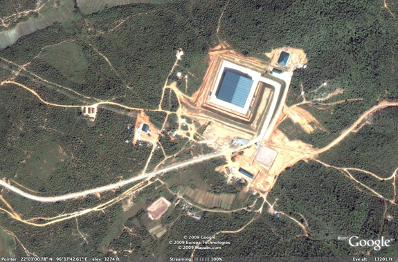
Over the past couple of days, I’ve been emailing with a couple of colleagues about this very odd building in Myanmar (nee Burma). Staring at that big box was the main reason I tweeted that “This Burma-NORK nuclear link has me worried.”
Allen Thomson, Bruno Tertrais and some folks at VERTIC all found it too — working from the recent story in the Sydney Morning Herald and an older story originally published by an opposition group. We’d been quietly discussing what the thing might be.
Now, no one wanted to go declare the vaguely suspicious looking building to be something suspicious in particular — but since ISIS has found it too (the damn thing is visible from 4,000 feet) and published a nice analysis, I don’t suppose there is any harm in crowdsourcing it.
ISIS describes what I am calling the BOB (let’s leave the M out for now) as an “anomalous building” — noting that they cannot “ascribe [it] with obvious nuclear industrial characteristics.”
It’s big and tall. It is also nestled into the mountains and revetted. There seems to be a power transmission line running in (or out of it). It is several clicks from an obvious water source.
Still, someone has been very interested in it —in addition to this 2005 image, Digital Globe has happy snaps from 2008 and 2009 centered right on it.
What do you all think?

The obvious thing is to match up its dimensions with the Syrian Box-on-the Euphrates.
It is much, much bigger — 80 meters on each side.
I tried my hand at finding “Naung Laing” earlier today, and although I wasn’t entirely successful it seems that the box is a ways off from there.
The framing of the building, with the auxiliary structures at a respectable distance and the white sort of courtyard has the feeling of a palace to me, although that certainly is a big ol’ powerline leading up to the site, not sure if that’s over the top for feeding a non-industrial building.
You can follow the power lines all the way through the city and to the air strip and the iron mill to the south west of the building.
82 meters by 84 meters. Almost square but not quite, although the difference could be distortion in the imagery.
Sydney Morning Herald sez defectors said it was made with Nork help, and that there is a Russian reactor nearby?
Da?
Where is the Russian civil reactor?
Nimby applies in Mynamar as much as it does on Long Island. State Peace and Development Council chief General Than Shwe has a mansion in between Anikasan Airport and Pyin Oo Lwin, not more than a 6 klicks from the “box”. Built by Htoo Trading’s construction arm, aka what Tay Za does with his spare time when not running guns. It’s highly unlikely the honourable Than Shwe would wish to live in the proximate neighborhood of a nuclear reactor.
As to the purpose of the “box”, Mynamar is undergoing a major government sponsored construction boom. Since they’ve moved their capital from Rangoon to Nay pyi daw, they’ve been investing heavily in the Mandalay – Pyin Oo Lwin corridor; industrial infrastructure, technical schools, silicon villages, take your pick.
An olympic swimming complex?
Does anyone have coordinates for the alleged underground facility mentioned in the Ball and Thorton article?
@FSB: According to the Grey AP article, “In 2007, Russia signed an agreement to […] build a 10-megawatt nuclear research reactor for peaceful purposes. […] However, Russia’s atomic agency Rosatom told The Associated Press recently that ‘there has been no movement whatsoever on this agreement with Burma ever since’.” There are no existing research reactors in Myanmar per the IAEA’s RRDB. As for a clandestine reactor, Mark Fitzpatrick expresses doubts in the SMH article, and I cannot imagine the Russians desperate enough to risk such exposure or the Burmese able to pay enough to have it done quickly & quietly.
@MK: Though it may seem like a cavity (with some nice swimming lanes, no less), it is actually a blue roof.
Certainly to me the most interesting characteristic is the revetment mentioned in the post; seems like a significant investment in this particular structure.1 It obfuscates the shape, side detail and dimensions of the building and also provides a fortifying element. Judging from the shadows, the roof cannot be all that taller than the top of the ramp, leaving most of any building encased or beneath ground. Also, the ramp doesn’t seem designed to handle much traffic (ie, multiple trucks/loads to or from the facility), but that could be my misjudging the scale.
1. Maybe not in a command economy, but it is still quite peculiar.
I don’t see any sort of serious perimeter security – there are a couple of guard towers, but it’s in a jungle, and in hills, and they don’t have an outer fence perimeter or even a serious guard post on the road.
I would guess something related to the Myanmar government, given the two towers and the berm and ditches, and something explosive (otherwise, usually you fence, rather than berming). Power in quantity would tend to indicate more than just an ammo dump, but it could be any number of sensitive things involving explosives without being nuclear in nature.
The holes in the mountains near Napidaw are more interesting, if harder to divine.
The annoying aspect of the Australian “breaking” story—as usual I guess, to my jaundiced mind—is that it is a mixture of fact and fiction. If you read it carefully what will likely turn out to be the fictional bits pop out at you. I know where I want to be in about 24 hours but I’m not hot-dogging into print this morning.
Where are Yale and Hairs when we need them?
It is pretty clear that the BOB is in the right place.
The facility is southeast of Pyin Oo Lwin in Mandalay Division.
Moreover, although there are many villages called Naung Laing in Burma (Myanmar), according to a 1901 Gazeteer of Burma there is a village of that name “eight miles east by a little north” of Maymyo (Pyin Oo Lwin).
That would be consistent with the terminus of the road that leads out of the facility. Which, in fact, is how I found it. I went east out of Pyin Oo Lwin and saw the shiny, new road and followed into the mountains.
Hairs is still around, but hasn’t posted for months in deference to trying to keep his employer happy in these straitened times!
My first impression is: great swimming pool – does it have a diving board too!?
Second impression: Hmmmm…? I’m intrigued by the wide turning circles of the access road’s bends; all except for the tight 90 deg bend at the top right-hand corner, where one would have thought it would be most critical. All of which seems to suggest that whatever goes in / comes out is not over-long.
Apart from that, I’ll have to prepare three pipes and look at it properly at the weekend.
Actually, maybe that last comment of mine should be cancelled. I hadn’t appreciated just how enormous the site is: I’ve just measured up on Google earth and the road is about 12m wide at the turn – so you could almost take an articulated lorry in sideways!
George William Herbert, there’s a major military checkpoint on the blacktop highway before you get to the big temple 22° 3’36.96“N 96°32’6.03“E
Are the newer Digital Globe images online somewhere?
Do they show more perimeter security in place now?
JL: Doh! I should have looked harder at the actual report before hitting Google Maps.
19°52’31“N 96°20’45“E
Looking at the road leading into the box, I can’t come up with a better reason for the J shape than that there’s a significant height difference between the box and the road and that whatever is supposed to travel between the two is heavy enough that only a small inclination is allowable. Sort of like those models of how the Egyptians supposedly dragged rocks up their pyramids.
Gump – that’s a checkpoint of some type, across their National Highway 3 ( I assume, from the map markings ). But it’s not a useful perimiter. It’s 4 km from that to where the road to this site turns off. Inside that perimeter are an easy dozen hamlets. I don’t see a symmetrical checkpoint north on National Highway 3 (could be missing it, but I looked a ways north).
Perimiter security for a nuclear facility would be in closer and far tighter than that. A checkpoint on a major highway, that far away, obviously could help pay attention to comings and goings. But NH 3 goes up to China and is apparently a major trade route. I am not seeing any major security installations between where the access road meets NH 3 ( at around N 22 03’ 52” E 96 34’ 15” ) and the large facility. There are several side roads to villages which eventually meet / cross the main access road. There appear to be terraced farm areas in the next valley over to the north, and even just a bit away on the south side, just across the access road.
If that was a nuclear facility and I was in charge of security, there’d be a big security checkpoint around the curve of the road at N 22 3’ 8” E 96 36’ 57”, and a dual perimiter road and fence, one at the bottom of the surrounding hills at the far side, and one at the top of the hills, with clear areas 10m or more on each side, plus light posts and observation cameras (and probably, guard towers).
You see security like that at known nuclear facilities in many nations. It’s routine.
I thought to determine a position you needed three points. How many photos do you need to compare to guess at the hight of specific things in the posted photo?
A big cooling device?
A huge swimming pool would be a good disguise for it.
Evidence to date: Big important facility with roof on it that uses/produces electricity and has a road.
Enough with the pool jokes(?): it is clearly a roof and not water.
I challenge anyone to find me an official open source document or reference identifying where the Russian reactor is to be located in Myanmar. C’mon guys, emigre and dissident assertions don’t cut it, and in this case (Myaing and Kyaukse) they don’t even agree, they are hundreds of miles apart.
Security is not a definitive indicator of anything and one should not draw too many conclusions based on its presence or absence.
At this point that building could be anything. It’s certainly big enough to house a reactor, but reactors need cooling and I don’t see any evidence of a cooling system.
It is an intriguing and strange building – hopefully additional imagery and other information will be forthcoming that will tell us more.
> You see security like that at known nuclear facilities in many nations. It’s routine.
The BOE is a counterexample, if you accept the Standard Story that it housed a reactor.
Well, that is a puzzle.
(By the way, I can’t say enough good things about using the 3D Connexion “Space Navigator” 3D pointing device along with Google Earth).
The pronounced jog in the access road at 22° 3’11.07“N 96°34’50.73“E is easier to understand when we let GEarth supply elevation data and look obliquely; it’s a switchback on a hill.
The building itself, when zoomed in enough, can be seen to be a factory/warehouse like structure with a shallow-pitch peaked roof. A survey of others in the area show a lot of blue roofs; this could be either a military construction standard, or even the use of blue plastic tarp (sometimes called “smurf skin” for waterpoofing).
Interesting that the power line that has Big Blue Box on one end appears to have another end at 22° 3’27.70“N, where there are four odd looking little boxes. No idea what’s up there. But there’s a *bunch * of those structures (which I’m taking the liberty of naming “quadboxes”); I found seven of them running along a crooked 4km SW-NE line (including the one where the power line ends/begins, (KMZ file available on request) I’m sure there are some others. And why does only one of them need a power line? Is there a tunnel underneith? Haven’t spotted a portal yet.
Here’s a question of much diminished import: Why are the signs in Fig. 1 of the ISIS article in English? Did they conclude it was a dam penstock because it has a big sign over it that reads “Penstock Tunnel Outlet”?
BOE meaning the Building On the Euphrates, I assume here.
That building had good intrinsic site security – in a desert region, one side bounded by a river, a road several km away inland, no farming between the road and river on that side in the near area.
They added in berms on the ridgeline to block line of sight on the building from the road nearby. They also had a large, cleared field many km wide to work with for physical security. For a covert installation, you don’t need a solid fenceline – you do need a perimiter which is relatively easy to watch, and a way to prevent casual or directed intrusions.
If one went back further in time at the Syrian site, one would presumably find some small bunkers put in the ground, covered by terrain, with view slits looking out over the surrounding land. Entrances could be small enough to not show up on overhead photo imagery – they’d probably stand out on radar, but the US never released radar imagery of the site. There was no need to clear land to establish lines of sight / fire.
The dirt mounds along the ridgelines around the site would be good locations for bunkers – good visibility, and the dirt would help visually obscure the bunker’s vision slits and entrance.
If a kid started wandering across the desert, you just put a guy in a 4×4 out to drive up and tell him to go back to the road.
If there was a ground attack, you have a quick response force inside one of the buildings to respond, and the people in the bunkers can pin down attackers while the QRF gets rolling.
In a forested or jungle environment, as in this site in Burma, you really need to clear a perimiter and add a fence. While it’s technically possible to do that underneath the trees, it usually shows up anyways, and doing it underneath trees leaves enough trunks in the way to make lines of sight difficult.
The Myanmar facility could be using the ditch and the fence around the outside of the pad around the building for a single, close in perimeter… normal for industrial facilities, abnormal for something like a nuclear installation.
They could also have a virtual fence, with a fenceline in the bush somewhere to discourage casual trespassers, and a serious set of wired or wireless cameras and motion sensors covering at least up to and over the ridgelines a bit. That’s possible – difficult to make perfect, but possible. It takes a lot of manpower to watch all the cameras and make sure someone doesn’t sneak in.
they still use visible roofs.
it’s not difficult to use a less visible colour and receive less protests around the world
several clicks from a water source”? what the fuck is a click? watching too many Viet Nam movies I will type this slowly as your hard of reading KILOMETER OK ?
Judging from the amount of coffee and other produce that is grown in the cooler climes up that way I’d be more inclined to say it’s nothing more than a processing plant of some description. There’s certainly plenty of plantation in the surrounding fields. The auxilary buildings will be no more than the usual buildings you would expect to see at a factory in Myanmar, i.e. generator house, water treatement etc.
It could be an open air opium dryer, I’ve never seen one this large, but if this is a Tay Za operation it makes sense, he has the capital and the connections to pull this off. The blue tarp on top, completely unnecessary for conventional coffee or teak drying would be crucial to help prevent satellite and UAV recce of the operation.
Myanmar’s government is publicly very anti-opium; they consider the cultivation and distribution of narcotics to be equivalent to genocide in light of their colonial legacy of British imposed opium trade. However, it wouldn’t be the first time that an isolated government has been forced to turn to drug exports as a hard cash trade good.