Happy Friday, readers. My name is Tamara Patton, and thanks to the ever-generous Jeffrey, I’ll be a new guest contributor here. For those who’d like to know a little more about me and what I plan to offer, see the bottom of this post. For the rest who just want to hear something interesting about Parchin, keep reading…
Many of you know that the alleged high explosives testing site at Parchin remains a key element of the “structured approached” that the IAEA is proposing to resolve outstanding issues on Iran’s nuclear program. Experts in this area continue to debate whether this site is really worth the ultimatum – My colleague at SIPRI, Bob Kelley, recently gave his take in that debate, which was seconded soon after by Yousaf Butt.
As the debate continues, I thought it might be useful to take a closer look at how the many different dimensions we’ve been offered add up in the context of the site. I came upon some interesting discrepancies. Some of you know that I’m a fan of Google SketchUp — I gave the tool another go here.
Starting with the original drawing of the chamber (acquired by the AP and reportedly produced with information from an eyewitness), I was most struck by how off the reported dimensions seem in the context of the drawing. Jeffrey already remarked on the oddity of the Oompa Loompa-sized door in the cylinder. Another eyebrow-raiser is the diameter to length ratio of the cylinder (reported to be 4.6 m and 18.8 m respectively). In fact, as far as I could tell from modeling the photo in SketchUp, the length of the cylinder in the drawing is indicative of about 6 to 7 m – nowhere near the supposed 18.8 m figure. Maybe the artist was a Picasso fan, but the disproportion in the dimensions seems a little too pronounced to have been unintentional.

If you assume a 4.6 m cylinder diameter, the cylinder length depicted in the drawing indicates 6 to 7 m, not 18.8. (Patton, SketchUp).
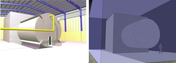
A related discrepancy is the placement of the collar in the drawing versus the way its dimensions are described by Danilenko (i.e. the second source of possible dimension info). The press drawing seems to deliberately indicate that the collar is located at the rear of the cylinder. Danilenko, however, describes that “the external part of the central section of a length of 9 m is strengthened with a reinforced concrete square section of 7.6 x 7.6 m2”. The key word is central. Apparently, wrapped around the center of the 19 m long cylinder would be this massive concrete collar, with the cylinder protruding on either side of it.
Like this:


SketchUp model of Parchin, illustrating how Danilenko's design would look if it were in the building. Dimension estimates: building length (30 m); building width (15 m); building height (~12m) ; cylinder total length (19m); collar length (7.6 m). (Patton, SketchUp)
Modeling these dimensions within the dimensions of the building at Parchin (heights are very estimated since these shadows are on a slope), the view above is what I got (shown with average height humans for scale). So, is the information that came with the drawing actually at odds with Danilenko’s design?
Yes – and no.
If the length of the 19 m cylinder is partially covered in the center by the concrete collar, that leaves about 5.7 m of cylinder exposed on each side of the collar. Interestingly, this is MUCH closer to the cylinder length that the original drawing depicts, seen here from similar viewpoints:
Comparison of AP drawing to SketchUp model depicting Danilenko’s design from a similar perspective.
So in this infamous drawing, are we maybe just seeing half the picture? It is an interesting thought, though it seems unlikely that an “eyewitness” would have missed the other half of the 19m cylinder sticking out the back.
As far as the likeliness of Danilenko’s design being used for the accused hydrodynamic testing, there seems to be some growing agreement that the concrete collar (especially if placed around the cylinder’s center) would interfere with the devices needed to make a hydrotest test useful, such as high speed optical cameras, flash x-ray systems, and neutron detectors. On top of this, as you can see from the SketchUp model, there’s not a whole lot of extra space in the building to support this kind of infrastructure once we use the dimensions described in the media and by Danilenko.
A final dimension of interest at the site is the heavy earth berm immediately south of the main building, which the IAEA says is indicative of the “probable use of high explosives in the chamber”. Based on modeling off of shadows in the October 2012 Google Earth satellite image, I estimate that it is around 9-12 m tall, so very nearly the height of the building (estimated to be around 12-15 m tall). It’s also about 6 m thick, 24 m from end to end, and located 4 to 5 m away from the main building.


The oddly shaped berm. ~9 m tall, 6 m thick, 24 m long. (Patton, SketchUp)
While this may seem like a large berm at first glance, it pales in comparison to the many other much larger berms in the greater Parchin complex. These berms are also significantly wider, surround entire buildings, and they are sloped on both sides. From the shadow casted by the berm in question, it is evident that it has a flat face nearest the building. Strangely, the height to width ratio is almost exactly what is required for earth-bermed explosive storage magazines (i.e. a 3:2 slope), as illustrated in the figures in this report, though I can’t think of any sane reason for storing ammunition this close to a structure. (Ignore this! Or see the comments for some better info.)
Bob Kelley says that small, narrow berms like the one in question are more likely used to shield radiation beams like those from an industrial x-ray machine or accelerator. He says that if the beam is collimated then you only need to shield where it is pointed. This makes sense. However, a remaining consideration is that unlike the closely packed buildings that the larger berms in the area are protecting, the site in question is much more isolated, and the berm is protecting the only two buildings around that would need to be protected. I think this prevents us from completely ruling out an explosive shielding purpose for this berm.
In brief, I think that the numbers we’ve been presented in terms of dimensions for this site at Parchin bear closer scrutiny. The two main sources of information don’t quite add up, and even if they did, the resultant design isn’t appropriate for hydrotests according to folks who know how those work. If there are any berm experts out there, I hope you’ll give your opinion – this berm is an anomaly amongst others at Parchin, and further investigation could result in a fun new rabbit hole to dive into.
(Here’s that introduction I promised: As you might be able to tell, my favorite area of work resides at the very tiny area of overlap between the worlds of arms control and digital art. Modeling has been very useful for wringing a third dimension of information out of satellite images and ground-view photographs, and I’m grateful to folks like Frank Pabian who have paved the way in this area . I’m hoping to push that tool into some new directions through modeling some new sites and hardware. I’m also excited about exploring new applications of other geospatial and data visualization tools for our field. In short, these sorts of projects, experiments, and ideas are what I’d like to share, and I look forward to hearing what you think. -TP)

Another excellent piece, Tamara, welcome aboard!
Your skills with Sketchup make your points much easier to understand and certainly enhance the conversation.
A couple of thoughts..,
As for the eyewitness account, if said witness had only been allowed to look into the building or perhaps even only caught a quick glimpse through an open door, they might well have only seen half of the chamber and so described it as they did. As your model shows, from the perspective of someone standing at one end of the building it would be impossible to see the other half of the cylinder without walking around the concrete collar.
As for the “Collar” itself, I wonder if it might not be a concrete shell or room that contains the instrumentation. I don’t know how sensitive this type of equipment is to dust and environmental conditions, but it would make sense to build a small sheltered area to protect the instruments rather than trying to control the environment in the whole building.
Something else I just noticed, that yellow pipe. Where does it go? As far as I can see in the satellite images, it doesn’t leave the building, which infers that it goes to some piece of equipment inside the already cramped space. Of course, we’re assuming it really is a pipe and not just a cable rack that has been misinterpreted as a pipe, but still.
This may be the alleged water feed of the alleged tank, for wash-down. If the alleged tank exists, of course.
And, of course, even if it exists it may not have necessarily involved nuclear materials (we are talking 10 years ago) so may not be relevant to the IAEA.
The other thing that is interesting is that the dimensions of a tank mentioned by Danilenko in his book is exactly the same as the supposed dimensions of alleged tank, same diameter and tank in the book has 19m instead of 18.8m.
Worthy of Curveball himself.
Thanks, Cthippo. It’s an interesting thought about the equipment being embedded in the collar. From conversations with folks, some think this could be possible (i.e. having “windows” in the collar to allow access for measurement tools), though not exactly plausible since the more holes you put in the collar, the less good it is for “reinforcing” the chamber as Danilenko describes. I also thought the same about the eyewitness only getting a glance at the thing from this one angle – but this puts even more holes in the intelligence that came with the drawing, as Bob Kelley pointed out to me. If the person had only had a one shot glance, he would have said it looked like the chamber was maybe 5m by 20m, not 4.6 by 18.8!
Tamara, brilliant work. Thank you. I am so pleased to see a technical discussion of the Pink Site at this level of detail. I hope with your expertise this will be a helpful didactic exercise in modeling and satellite photo interpretation, if you don’t object to sharing your skills w/ some of us rank amateur Google-heads.
Because I am so long winded, I’d like to break my comment in half, as the two halves are really distinct issues. One is about the history and significance of the “berm” and the other is about whether or not it’s a berm at all.
I would like to review the history because it is relevant as to whether or not what we are looking at is a “berm,” and, if it is a berm, what that means.
Mr. David Albright is revered by the US main-stream media as an ex-IAEA expert with a sharp eye for picking out potential Israeli targets. On Mar13.2012 he published an ISIS report that identified a “suspicious” area (35°33’30.77″ N 51°47’07.06″ E) that is near Parchin, and I emphasize “near” because it is not at Parchin (35°31’19.11″ N 51°46’16.92″ E) nor is it at the Parchin Military Complex, even though the ISIS report says otherwise.
This area, which I refer to as “the Pink Site” in honor of Mr. Albright’s later revelations, is much closer to (and hence more likely to be associated with) a hydroelectric dam project and a mining operation than it is to Parchin or PMC. The dam and the mine are just 2 km north of the Pink Site.
I make this distinction between the Pink Site and Parchin because by labeling a set of isolated buildings “Parchin” or as part of the PMC one immediately starts pushing bias-buttons, and pushed bias-buttons result in contorted interpretations of what satellite images show.
At any rate Mr. Albright made a big deal over the same berm that is the subject of your analysis, which is why you are analyzing it. The reason for all this interest in a berm is that the berm is being pitched as some sort of evidence that the adjacent building to the north is or was being used to carry out high-explosive tests related to the development of nuclear weapons.
This berm-as-a-smoking-gun theory originated from an IAEA Safeguard Report of Nov08.2011. Paragraph 49 of that report cites mysterious, unidentified “Member States” for the allegation that “[a] large earth berm was subsequently constructed between the building containing the cylinder and a neighbouring building, indicating the probable use of high explosives in the chamber,” as you note in your post.
And that sentence is the sum total of the publicly available “evidence” supporting the myth that the berm you are analyzing is diagnostic of dastardly goings on at the Pink Site. I call it a myth because the statement is, on its face, absurd. If a berm next to a building is a smoking gun, then the entire Parchin area would be covered in smoke so thick you’d not even be able to see pink-covered buildings from GeoEye.
Many, if not most, buildings in that area are bounded on at least one side by a berm. There are too many examples to inventory, but look at these buildings just north of the Pink Site – 35°34’37.55″ N 51°46’42.06″ E. And look at these buildings just south of it – 35°32’25.88″ N 51°47’07.94″ E. Bermed buildings abound in Parchin. The presence of a berm next to a building is indicative of nothing. This area was an active flood plain before the dam was built.
I thought I’d throw that bit of thorny berm-history out there because how much credit one gives to the ISIS assertions will determine whether or not one sees any berm at all. Next I’d like to get down to the nitty-gritty of your model.
wind, cont’d.
You speculate on the basis of your model that the Pink Site berm is the right size and slope for an ammunition dump, citing Tancreto et al. Below I take issue with this speculation based on dimensions, but here I question the speculation based on logic and my experience working around ammo dumps at Camp Lejuene and Camp Pendleton. I have a pretty good idea what an ammo bunker looks like and where they are placed, and from my experience they don’t look like that Pink Site berm, and they aren’t placed within a couple feet of buildings.
I would suggest that if you want to see what appears to be ammo dump bunkers in the greater Parchin metropolitan area, look at these bunkers about 4 km SW of PMC: 35°30’26.11″ N 51°43’11.87″ E. While these structures could be mass graves or really big gopher mounds, they are surrounded by a perimeter wall and guard towers and are what I would expect an ammo bunker to look like from my experience. Besides graves and gopher mounds are not usually ventilated like these structures are. I’d bet some money there’s ordinance in them.
Furthermore, does it make sense that a bunker used to hold ammo would be placed essentially right on top of a building where high-explosive tests are taking place? For instance, the Tancreto article you cite recommends that the “Inhabited Building Distance” should be 500-700 feet from the type of US bunkers you have compared the Pink Site berm to. And that is inhabited buildings; it is not buildings in which explosives are being detonated. And does it make sense that such a bunker housing ammo would be used to protect an adjacent building from blasts from explosive tests? This is just not adding up.
As for the dimensions of the berm, I know you are an expert in these techniques, and I have been fascinated with your online seminar discussing them, so I know I am way out of my depth here. But perhaps by offering the following simple analysis you would be good enough to sort me out if I’m wrong and further explain your conclusions.
In a few of the historical GE shots of the Pink Site, one has a good clean look at the shadow of the building and the shadow of the west corner of the berm. In most of the shots the bunker shadow is obscured by the building, but if you look at GE Mar04.2004, Sep12.2010, and Oct03.2012, you get measurable shadows and the building shadow is distinct from the berm shadow with respect to the western corners of both structures. The second to last mock-up diagram in your post shows what I am talking about. The two corner-shadows are obvious in that sketch.
If one measures the distance from the NW corner of the building to its respective corner shadow, and if one measures the W corner of the main part of the berm (not the wing) to its respective corner shadow, the ratio of these two measurements will be the ratio of the height of the building to the berm. I have done this for historical views of Mar04.2004, Sep12.2010, and Oct03.2012 and the ratios were 1.95, 2.09 and 1.76, respectively. Not bad agreement from 4000 feet up and photos spanning 12 years. Based on this quick calculation, the height of this berm is about 50% the height of the building it is next to. In fact, just eye-balling the shadows you can see that the berm is just about the same height as the small building directly to the south. On this evidence, I believe your estimate that the berm is the same height as the building it is next to – the one north of it – is excessive.
But, more importantly, I would question whether we are even looking at a berm, Mr. Albright’s sharp eye notwithstanding. My own tired old eyes tell me that this is no berm or bunker at all. What we are looking at is a wall made of concrete or other light material that is about 0.7-1.0 meter thick, at least to the limits of GE’s resolution. If you look at the Mar04.2004 GE shot, which is nearly directly overhead, you can see both the N and S faces of the wall.
That we are looking at a wall is also clearly seen in the GE views of Mar04.2004, Mar20.2009, and Sep22.2010 – the Mar.2009 view is the clearest. It’s a wall running approximately E-W with short wings at either end sloping toward the SW and SE.
Furthermore, there is no sloped land to the south of the wall. I see just flat surface. It looks like a smoothed parking area to me, which would explain the total lack of vegetation from 2004 to the present. The Oct.2012 photo is ambiguous because there has been some earth-moving going on, but based on earlier shots I don’t think once can conclude with any degree of objectivity that the dirt to the south of the wall is sloped or that it forms a bunker or berm.
Your exploratory modeling takes a pretty skeptical approach to this Pink Site thing, and that’s good. But a lot of people seem to be easily convinced by GeoEye shots interpreted by cable-news experts. Satellite photos are amenable to a strong power-of-suggestion phenom, and when an arms control expert who claims to be an ex-IAEA inspector tells the world there’s a berm at “Parchin” that is the same durn berm the IAEA says is a smoking-gun, next thing ya’ know, everybody’s peering at a wall on GE thinking it’s a berm or a bunker, and the next thing ya’ know after that F-16s are bombing it, and away we go. Again.
Denis,
Not convinced either way, having seen a lot of these berms myself, and having seen “block houses” of many different styles.
It is possible that the one building does contain a chamber for explosive tests, and that in the event of failure following a test, it was considered prudent to protect the operators of the test in the adjacent building from blast effects.
Or it could be something else.
No way to know without an IAEA visit.
Denis, [re-editing my comment]
Not convinced either way, having seen a lot of these berms myself, and having seen “block houses” of many different styles.
It is possible that the one building does contain a chamber for explosive tests, and that in the event of failure following a test, it was considered prudent to protect the operators of the test in the adjacent building from blast effects [in the event of an accidental failure of the blast containment chamber].
Or it could be something else.
No way to know without an IAEA visit.
Thank you, Denis.
MK
Denis, thanks very much for your insight on the “berm”. Happy to give a brief rundown of how I got my height estimates. It would be helpful to see how you’re measuring the shadows to get your ratios – The measurement should be from the tip of the shadow to the corresponding point at the base (not the roof) of each structure. In general, I stayed away from this approach due to the difficulty of determining where the base points are. Because of the satellite’s angle, it’s particularly difficult to see where the berm’s shadow would end against the base of the berm. Same goes for the main building, though you can sort of make out the edge of the base along its northernmost side in some images (especially in the Oct 2012 and Sept 2010 images). Also, because these shadows are on a sloped hillside, I couldn’t use the method I described in the youtube video (i.e. the sun azimuth calculation) since this relies on the accuracy of manual shadow measurements. What I did instead (for both the buildings and the berm) is construct the objects such that their simulated shadows casted in SketchUp match the shadows on the satellite image. If you squint at the images of my model (especially the direct overhead shot), you can see where the clear lines of the simulated shadows are intersecting the more blurry shadows on the satellite image – the matchup isn’t perfect in all areas, but it’s as close as the software will allow. Because SketchUp incorporates Google Earth’s terrain data, this method is the most likely to give adequate height results, although it relies completely on the accuracy of Google Earth’s terrain data, which I’ve heard can be shoddy in some areas (though supposedly it’s improving overall). Measuring the completed model, if you measure from the western edge of the berm (ground to tip), you get a 9m height, if you measure from the eastern edge, you get 12m, hence my stated range. The building is definitely taller, though I wouldn’t say by 50%. From it’s western edge, the model indicates that it’s 12m tall; from its eastern edge, 15m. So in either case, modeling indicates that the building is about 3 m taller than the berm. I hope this makes sense.
I definitely take your point on the unlikeliness of ammo storage here so close to the building – just meant to point out that in my perusing, this was the only framework I came across that was similar to the “berm” in question. I see now though that I got the slope comparison wrong – the magazine is 3:2 (x:y), and the berm is 2:3 if you accept my 6m:9m estimate. In this respect, it makes a lot more sense that this taller, more narrow structure could be an earth-reinforced wall as you and Raj suggested – more so than any kind of storage. Especially when we look at the bunker field you pointed out – these are wider (and seem to be shorter, though I haven’t taken the time to measure closely) than the berm/wall at the “Pink Site”. But if it is ‘just’ a wall – do you think that at all diminishes its possible role as a shield from high explosives?
Tamara – Sorry to take so long to respond you your response yesterday.
OK, I think I have a pretty good idea of your technique and it’s obvious that we are on slightly different tacks. You are looking for actual, absolute linear distances to tussle with the question of what could fit in that building. All I am looking for the relative heights of the blast wall and the building.
So your data are more useful but harder to get and dirtier. My data are a lot less useful generally, but cleaner. I mean, the measurements I take are wide open and there’s no guessing about where the base of the wall starts or where the bottom of the building is, etc. All of those pesky unknowns drop out of the calculation when taking the ratios.
The line I get when I measure from the corner of the roof to it’s respective shadow point, is the hypotenuse of a right triangle. The vertical of that triangle is the height of the building at the corner and the angle opposite that is the sun elevation angle.
The other line I get is the hypotenuse of a right triangle in which the vertical is the height of the blast wall, and the angle opposite that is also the solar elevation angle. The analogous angles of these two triangles are all equal, so the ratio of these two hypotenuses will equal the ratio of the heights of the building/blast wall. This ratio is about 2.
I guess one could argue that the hypotenuses I am looking at are skewed because the satellite is not exactly over the triangles. Yes, but any skewing of the hypotenuses due to the satellite angle will drop out too because it is the same for both triangles. So, I’m pretty confident about the heights being about 2:1. But then again, I’m confident about a lot of things I get wrong.
One doesn’t really need to do any measurements or calculations to determine this ratio of heights. You can see it just by eye-balling the shadows. If that blast wall were as high the building, the corner shadow of the blast wall would be even with the SW corner shadow of the building. Not even close.
You suggest that these measurements are complicated b/c the shadows are falling on sloped terrain – I don’t see that. The shadows are falling on the paved area bordering the western side of the building, at least on the views I am using to get my measurements. The Oct.2012 view is in a lot of ways the worst one to be working with as far that blast wall goes. Mar20.2009 or Sep22.2010 show it best.
You also note using Google’s terrain data via Sketch Up. I presume those elevation tools are the same as using the elevation tool and elevation profile in GE. We are only looking at a couple of feet difference in this area as best I can tell, and I wouldn’t trust the GE elevation data to that resolution. For instance, I read the elevation to be about 3972 ft. over most of the area around the S end of the building. But I measure the W side of the building (3975 ft) to be 9 ft. higher than the E side (3966 ft.) at the mid-point of the building. No way.
GE also says that the rough area to the W of the building is increasing in elevation, which would mean that open culvert is directing water toward the building. I don’t buy that either. So I don’t think the GE elevation data are sufficiently precise for this sort of work, which may be why your conclusions are so different from mine regarding the relative heights.
It looks to me like the west side of the building is level where the paved portion is [in earlier GE photos], then drops slightly to a shallow ravine, and then rises sharply 30 ft or more. This could be important. This area has not been disturbed in any of the GE photos going back to 2004. Bob Kelley has suggested that if IAEA wanted to find traces of nuclear goofing around, they would find it in this area, and so why would IRI go to all the trouble Albright is suggesting to “clean up” the rest.
You’ve noticed my dropping the term “berm.” I don’t know who first applied that word, IAEA or Albright, but the evidence for a berm is next to none, at least as I understand “berm.” I go with Raj here 100%. It’s a wall about 1 m. thick. The term “blast” seems appropriate only because this wall has wings at either end, angled back toward the SW and SE, like a blast wall. The Mar20.2009 shot is the best view of the wings.
So my take is that this is a blast wall – just high enough to protect that small building to the south. This sounds more like a site for testing jet or missile engines, doesn’t it? Sure doesn’t look like a flood-control wall or hand-ball wall, eh?
So, to my mind, the question becomes what would they be doing in there that would require a blast wall only toward at one end? I mean, this doesn’t smell like containment of radioactivity. Anon talks about “blast effects”, but I take a blast to go out in all directions. This looks more like it’s blocking a directed force, like a jet engine exhaust.
Look at 7 km almost due W of the Pink Site. There are a series of interesting double-buildings that are all tightly surrounded by walls. Here: 35°32’52.70″ N 51°42’39.23″ E I count 5 of these doublets, and they are easily visible from 30,000 ft. 400 m. W of the northern most of these double buildings is what looks like an elevator shaft or cave entrance. If I were IAEA, that’s where I’d look. Forget the Pink Site.
Denis
Sun angle and satellite angle will change for both measurements since both are taken at geographically different locations. The logic would not hold water if the roof is protruding out from the building as is generally observed in slanted roofs especially here.
If it was only a wall without the earth support, then it would show a shadow of the inclined portion on the Eastern side.
Thanks, Denis – I think we’ll have to agree to disagree on the method for now. Measuring to the roof tip won’t get you anywhere – GE measures distances horizontally, and a hypotenuse would of course be sloped.
If you want to keep to the ratio approach, I think you need to make sure both of your lines are at nearly the same angle (i.e. along a very similar sun azimuth), otherwise you’re skewing the comparison. The sun azimuth angle of the September 2010 image is 151.17 degrees. If you use this angle to guide your line placement, you’ll be guided to the corresponding base point against the object which is casting the shadow corners.
Here’s my placement:
http://img217.imageshack.us/img217/2974/bermbuildingheightratio.jpg
The ratio comes out to 1.19 for this image. Granted, the sun azimuth in actuality will be very slightly different for each object, but given this short distance between the objects, I think it’s best to just stick to the overall image azimuth.
Tamara
Here your mensuration is absolutely incorrect.
You are measuring the building from its base which is at a step higher than the ground on which shadow is falling.
You are measuring shadow of the roof top which happens to be protruding out from the building (clearly observed in the image you posted on imageshack).
You are measuring the blast wall shadow from top of the wall and not the base.
According to your type of mensuration, the correct ratio would certainly be around 1:2.
Check this comparison of shadows on your pic.
http://www.scribd.com/doc/124135258/Compare
I have also added two yellow lines to compare the width of building and width of roof.
Length of both yellow lines are equal. And both red lines are equal also equal to your red line.
Raj, I don’t think this is worth argument, since as I mentioned in the beginning, this is not a good method for this site (due to the obviously many ways you can argue for adjusting the line placements). With the photo I posted, I was illustrating the azimuth concept for Denis.
The 3D modeling approach (combining GE and SU) is a better way, since you are forced to replicate the entire shadow perimeter versus choosing a few arbitrary points. This method has yielded great results in the past, which is why I’m still using it.
The BEST way as some have mentioned would be to purchase an image product with better elevation data if it’s decided that heights are critical to the analysis. I agree that the nature of the terrain at this particular site may warrant this more robust approach.
More importantly, what would be the significance (if any) if the wall was 50% the height of the building versus 75% as I suggested? I’m interested in Denis’ suggestion that this layout could be used for testing jet or missile engines due to the need for protecting against a directed force. If experts in that area think it’s plausible, that would be a new argument for needing this type of narrow, earth-reinforced wall, versus past expert claims that this structure is most likely useful for shielding directional radiation from an industrial x-ray machine/accelerator.
Tamara, I agree, we’d be best just to chalk our trigonometric differences up to differences and let it go at that.
But one doesn’t need any trigonometry to see the sizes of the shadows. Aint’ no way that wall can be 80% the height of the building and cast a shadow that is only 50% as long.
I note that the photo you’re using doesn’t allow you to easily distinguish the building from the wall. In the Mar.2004 shot one can see the entire wall separate from the building. There is no overlap. You can see both wings clearly and you can even see shadow at the south face of the wall. The full monty.
It’s beyond any reasonable doubt that it’s a wall with two sloping wings, and just eye-balling the shadows there’s no doubt in my mind that the height of the wall is about the same as the building to the south and about 50% of the building to the north.
Here is the shot with my lines added.
http://thepatentguy.net/PinkSite/pink-analysis.htm
It’s just really impossible for two structures of the same height standing next to each other to throw shadows of differing lengths. I’m sure some Greek must have made that point somewhere.
Now, as to whether there is sloped ground on the south side of the wall, one could look at it either way. I see a flat surface there, but I can see how others would see a graded slope. To me, that partial wall-shadow on the south face in the Mar.2004 photo suggests flat ground.
Like I said before, it doesn’t look like a hand-ball wall, but, on reflection, that’s as good a guess as any I’ve seen. If we want to take Albright’s bait and think dark and dastardly things, then maybe it’s for a firing squad, in which case in addition to the IAEA we should demand the UN send in the UN Human Rights Council. I’ll stick with hand-ball.
Nor is there any a priori reason to conclude the function of the wall is associated with what’s going on in the north building. Maybe it is associated with the south bldg. and is protecting the north building.
@Raj “Sun angle and satellite angle will change for both measurements since both are taken at geographically different locations.”
Well, I guess I wouldn’t consider structures that are a few meters apart as being “at geographically different locations” with respect to the sun, which is 1.5×10^11 m away, the satellite, which is on the order of 5×10^5 m away. The differences in these angles will be too small to matter.
Denis
You said
“I note that the photo you’re using doesn’t allow you to easily distinguish the building from the wall. In the Mar.2004 shot one can see the entire wall separate from the building. There is no overlap. You can see both wings clearly and you can even see shadow at the south face of the wall. The full monty.”
The shadow you measure is to the North/NW of the wall.
I would like to see any straight object throwing shadows on both North and South side, even partial.
The shadows in pptx posted by me clearly show how they differ in size.
Here is my reading of the ‘oddly shaped berm’ which can be called blast proof wall. Pardon my bad drawing.
http://www.scribd.com/doc/123571859/BlastProofWall-pptx
The size is approximately 1m thick concrete wall supported by compressed earth/stone & earth. The total thickness at bottom is approximately 9m at the top would be 2-4m. The length of main wall is 16m and total with inclined walls on sides is 24m. Height certainly lesser than the building.
Such walls are generally used to prevent blast effects being transmitted to other buildings nearby.
No, they are not used to shield radiation. Radiation can be stopped by thinner metal walls invisible to outside world.
The ISIS has published reports with latest satellite imagery of 1/17/2013.
http://isis-online.org/isis-reports/detail/taking-stock-and-moving-forward-on-the-issue-of-the-parchin-high-explosives/
In that report ISIS argues that the IAEA should invoke “special inspections” to gain access to the site, instead of pressing for a 3rd voluntary inspection of Parchin. (The first 2 visits found nothing incriminating).
This is a good idea: let the IAEA call for special inspections if the evidence is solid enough to warrant such.
Thanks, Raj, the drawings are helpful – do you happen to have any sources on ‘blast proof walls’ that you’re able to share here?
Just a couple of questions.
I would highly suggest moving out of the Google Earth and Google Sketch realm as the accuracy of your work reflects the limited data you are accessing.
Why not move towards an ArcGIS environment with higher resolution as well as DEM data modeling? I understand the open-source approach you are taking yet you are working with data that is 90m SRTM at best. Your estimations are based off of resolutions which require something of greater fidelity.
Again. Moving off of Google Earth will vastly improve the veracity of your assumptions. I am surprised Frank Pabian is referenced as paving the way for this kind of work since this methodology is like using a cleaver for surgery.
Dan, I think I make it pretty clear in the post & comments that these are estimates (not assumptions) based on free software. I also point out that the height estimates are especially uncertain for this particular site given Google Earth’s terrain data issues and the seemingly sloped landscape here.
In my work, whenever necessary, I use better elevation data along with ENVI to test the Google Earth/SketchUp results. GE/SU aren’t perfect, but they can still be valuable free estimation tools when used with care. Alas, I’m not able to purchase pricey TIFFs and DEMs for voluntary blog work, but if you’ve got the bucks, please go for it!
Dan & Tamara
The DETD resolution is generally 900, 90 and 30 meters depending upon what level (0, 1 and 2) data you are using.
It does not gel well with high resolution satellite imagery and hence you end up getting wrong heights.
Someone can get hold of latest data for this location from OV-104 or 105, then the measurements would certainly be accurate.
In this case, the area is carved out of mountain side. So the elevation data would be much less accurate.
This nitty gritty speculation about the height of buildings etc. misses the broader point: Do we actually know if nuclear material were diverted for use in this supposed explosion test chamber? No. In fact, to the contrary, the IAEA has consistently stated that there has been no diversion of nuclear material for nonpeaceful uses. The latest IAEA report itself says that the alleged activities in Parchin were “nuclear-related” rather than nuclear. Iran is perfectly free to investigate whatever it wants without telling the IAEA as long as there has been no diversion of nuclear material, and there is no safeguards requirement for Iran to report non-nuclear experiments or studies. This is aside from the fact that the IAEA was already allowed to visit Parchin twice, and conducted environmental sampling which turned up no indications of fissile material. So other than pure speculation, what actual basis does Albright or the IAEA have to demand access to Parchin? None.
I’m sure we can all obtain google earth photos of the terrain in any NPT signatory country, located buildings and berms and walls, then proceed to speculate about the possible things that may be hidden behind these structures. But that’s not proof of anything. Hell, its not even a decent allegation. Regarding Albright, note that he first claimed the Parchin should be checked simply because it was deemed by him to be a “logical candidate” for nuclear weapons testing — and that’s all. Following the initial IAEA inspection of Parchin, which found nothing, he demanded that the IAEA visit Parchin again and this time check another location, simply because there was “construction going on” there. That’s all.
The closest the IAEA seems to come to claiming the possible use of nuclear materials at this particular site is tied to the issue of hydrodynamic testing in the alleged chamber (seen in section C.7 in the Annex of the Nov. 2011 report). The language is artfully fudged to avoid saying they expect to find nuclear materials at the site, especially since hydrotests can be done with surrogate material. In light of this, I think it’s important to continue to vet as much as possible the claims about the reported chamber’s suitability for hydrotesting in particular.
I’m with you, Cy.
Ultimately, the question is whether or not there is enough “stuff” in these aggregate sat photos of the Pink Site to justify IAEA or anyone else demanding to have a look. I think that question has to be resolved on the basis of treaty obligations and not what some unidentified “Member States” say they see in the photos.
ISIS has said a couple of times that there is a sat photo from 2000 of this building being “built around” a cylinder. That photo would be the smoking gun, but ISIS, so far as I know, has never published it. The earliest photo I have ever seen of the Pink Site is Mar.2004, GE. I’d be grateful if anyone can direct me to the 2000 photo.
Finally, look at that Jan.2013 shot in the ISIS report that Raj links to. That is stupendous! As of Oct.2012 it looked like they were tearing this site down, but no, they’ve been renovating. They are rebuilding the fence, repaving the drive, the black tarps are off the buildings and they look like they have new roofs. All of the mounds of dirt to the east have been smoothed out and they’ll probably be planting tulips since spring is coming. Next they will be inviting us all over for tea and biscuits to celebrate the re-opening of . . . ????
“Next they will be inviting us all over for tea and biscuits to celebrate the re-opening of . . . ????”
Does anyone else have this nagging suspicion that the reason why the IAEA is “asking” to visit Parchin (rather than demanding a “special inspection”)is because they aren’t absolutely sure that Iran isn’t just pulling their chain?
You know, draping those Pink Tarps over buildings, doin’ all that landscaping, etc., etc. for no other reason than that They Know This Will Drive David Albright’s Brain Into Meltdown….
I’ve always wondered about that, not inly in the context of Iran, but especially North Korea. Why not continuously do things that look suspicious, get everybody worked up into a lather, then invite them in to look at an empty building.
If I was Kim Jong Un I would have a group that did nothing but drill large holes in the ground and run cabling into them, while another group set up reviewing stands nearby. Do this all over the country. Every time someone needed a new well they would get a hole suitable for testing bombs in. That way, when you actually want to test something, no one knows which hole to look for it in.
Tamara — even if Iran had conducted hydrotesting in this alleged chamber, the fact is that unless it involved undeclared fissile material, and unless it was “non-peaceful”, then Iran would not be in violation of any NPT obligation or safeguard.
NPT signatories are perfectly free to quite legally conduct whatever experiments they want, even if these are directly relevant to making and launching nuclear weapons — UNLESS there is an undeclared diversion of nuclear material involved.
So EVEN ASSUMING that Iran conducted such tests in such a chamber, the IAEA has no authority to demand access UNLESS they can show that there was undeclared nuclear material involved.
And there is thus far zero evidence of any nuclear material having been used there. Quite the contrary, the IAEA has consistently stated that all nuclear material in Iran has been accounted for. And, considering the potential for contamination of not just the chamber but the entire building it is located in, and the fact that no traces of fissile material have been found there in the last 2 visits, then there is no reason whatsoever to simply assume that any nuclear material was used. Therefore, the IAEA simply has no authority to demand access to Parchin. And yet the Iranians allowed the inspectors in twice already, and have said they’ll let them again as long as 1- they’re allowed to see the evidence that they’re supposed to refute, and 2- there is a modalities agreement in force which will put an end to the potentially endless cycle of speculation leading to demands for extra-legal access that we’ve witnessed thus far. Why have these Iranian concerns been ignored? Because the entire Parchin story is a redherring intended to be used to scaremonger about Iran, that’s why.
Denis
Here is the March 2000 image on page 4
http://isis-online.org/uploads/isis-reports/documents/Parchin_March2000Image_10April2012.pdf
Cthippo — You ask why Iran just doesn’t allow the inspectors in again to resolve this issue but (aside from the fact that Iran has stated its concerns that the IAEA is sharing intelligence on Iran with the US, just as the Iraqi “weapons inspectors” turned out to be infiltrated by the CIA) your argument rests on an assumption that a third visit to Parchin by the IAEA would in fact resolve the issue — but I’m sure Albright can find a building, wall, or closet someplace else in Iran then proceed to scaremonger about how it is yet another “logical candidate” for hidden nuclear weapons work.
Iran already allowed the IAEA to visit Parchin twice, even though they were not obligated to do so. They made the entire Parchin area available and let the inspectors select the sites they wanted to visit. So how many more times is this supposed to be repeated? Would ANY country allow foreign inspectors to just traipse around in their military bases with no justifiable reason? Did the world suddenly rewrite the IAEA Statutes and safeguards to grant unlimited powers of inspection to the IAEA…when it comes to Iran specifically? No.
Even Hans Blix pointed this out:
“Any country, I think, would be rather reluctant to let international inspectors to go anywhere in a military site,” Mr. Blix told Al Jazeera English… “In a way, the Iranians have been more open than most other countries would be.”
And
“The selection [of target buildings] did not take place in advance, it took place just when we arrived, so all of Parchin was available,” recalls Heinonen, who led those past inspections. “When we drove there and arrived, we told them which building.”
http://armscontrollaw.com/2013/01/22/yousaf-butt-pretty-in-pink-the-parchin-preoccupation-paradox/
Ultimately, the “wonks” need to come to terms with a fact: You’re all very gifted and well-informed about the technicalities of nuclear proliferation and can draw lovely pictures from satelite images etc. However, the issue is NOT about nuclear weapons and never was. You’ve been misdirected. This is fundamentally a POLITICAL dispute between the US and Iran, in which the nuclear issue is simply being used as a pretext for for a broader POLITICAL agenda: imposing regime change on Iran – just as “WMDs in Iraq” was a lie and a pretext for a policy of imposing regime change there.
And as long as that’s the case, no amount of inspections or other technical measures will ever resolve the issue.
In short, this isn’t about Parchin at all.
Heck, even the US doesn’t accuse Iran of making nukes, but instead accuses Iran of having the “intention to acquire the capability” to make nukes at some indefinite point in the future. And since future intentions cannot be “inspected” nor disproven by the IAEA, no amount of access to Iranian facilities will resolve this standoff until the underlying political agenda is resolved.
I agree with many (though not all) of your legal points, Cyrus. The point of my post (and those “lovely” pictures) is to critically test the elements being put forth in the media as ‘incriminating evidence’ for this site. Since the IAEA is leveraging the notion that the alleged chamber can be used for hydrotesting – which could possibly include nuclear materials – as a reason for needing a visit, I don’t think examining that claim here from a technical standpoint is a bad thing. I’m new here, but I always thought the blogger’s creed was “read the post before you bash it.”
I probably have 100 hours into analyzing this blinkin’ Pink Site, not because I believe Mr. Albright’s characterizations, but because I am totally skeptical. As I said, I agree with Cyrus. And as I also said, I am delighted to see Tamara, or anyone, dissecting this thing in such detail. Seems to me that Cyrus and Tamara represent two sides of the proverbial coin, a 50 rial piece in this case, I guess.
If this was a compound in the desert outside of Bakersfield, CA purported to belong to the SPCA, the task of trying to confirm that with GE images would still be a fascinating project technically. But with the Pink Site, given the political implications – including those Cyrus raises – I lie in bed and wonder things like: “Why the hell would they have a blast wall next to that building so far away from the military complex?” That question is 20% political and 80% non-contextual curiosity.
The ISIS reports are fascinating and well written, but in the end they have contributed nothing more than gross speculation. The approach has been: “Oh, lookee there!! That building could be a bomb site and so the world should demand a look inside.” One way to throw cold water on this nonsense is to analyze those sat photos objectively, which is why Tamara’s trigonometric analysis and modeling are so welcome. If the dimensions of the building are not consistent with Albright’s speculations, then end of story – and that has political ramifications, both in terms of justifying targeting Iran and ISIS/IAEA’s credibility. OTOH, if the dimensions of the building are consistent with Albright’s speculations, then it doesn’t mean squat. The Middle East is full of buildings of that size.
The intellectual and technical challenge of determining what is going on there is fascinating aside from any political implications. For a private, myopic, agoraphobic individual like me to be able to sit here in my office in Vancouver in my slippers and measure the width of a building in Iran 16,000 km away boggles my mind. I don’t even need a tape measure. And when Tamara brings to the table techniques for determining the height, my ability to suspend disbelief begins to shut down. She doesn’t need a tape measure either. Pythagoras would be all over this; why shouldn’t we?
I didn’t ask why Iran doesn’t let the IAEA in, I asked rhetorically why nations under the international community’s microscope don’t build suspicious looking sites, leak data to generate hype and fearmongering, and then let inspectors in to see empty buildings. This kind of intentional maskirovka (sp?) would quickly discredit the IAEA and intelligence agencies who try to influence public opinion by selectively leaking juicy rumors.
I fully agree that this is not about the possibility of an Iranian bomb, but rather about certain hardliners in the US who will accept nothing less than forcible regime change and certain factions in Israel who define their security in terms of denying the rights of others. In neither case are these groups a majority, but in both cases their views carry enough weight that they can’t be ignored by those seeking to end the conflict.
It must be said that certain folks in Iran aren’t making the search for a deal any easier with their rhetoric and refusal to admit that yeah, they probably had a program a few years back.
That’s why I don’t see any sort of meaningful agreement coming about in the foreseeable future. The moderates on both sides who want to resolve the conflict and move towards more normal relations have their hands tied, again on both sides, by hard liners who define victory as the absence of compromise. As I’ve said before, I think the status quo will remain in place until the sanctions decay naturally.
Tamara – I wasn’t bashing anything. Just saying that really, all this is beside the point. Sure we can spent time analyzing and either endorsing or debunking media claims about Iranian nuclear weapons programs — but that risks giving legitimacy to the claim that this standoff actually has something to do with nuclear weapons. Just pointing out that it doesn’t. Not really.
Tamara, nice work. I’m trying to figure out what we know about Parchin and how we know it, absent the personal attacks and unsupported assumptions that have marred too much of the discussion. Reconstructions like this are useful in trying to understand the available information.
Something that I have noticed on the overhead photos and your reconstruction is that this berm is quite tall and narrow. I suspect that it must be constructed of concrete, rammed earth, or some cohesive material rather than soil, because its sides seem to exceed the angle of repose for soil. Have you looked into that?
I think Tamara’s point about the berm is actaully pretty simple. The IAEA report says:
A large earth berm was subsequently constructed between the building containing the cylinder and a
neighbouring building, indicating the probable use of high explosives in the chamber.
Parchin is a huge ammuniton plant and if you take the time to look around the site it is clear that the berm at the alleged testing area is tiny, not large. It has a concrete wall on one side abutting a driveway that goes along the south of the building and it protects an extremely small angle of hazard unlike other berms at Parchin that are clearly related to high explosive operations.
So why does the IAEA claim it is a large berm when a cursory examination of the site suggests it is the smallest berm at Parchin? And why do they claim it is a probable indicator of high explsoive operations when that is only one possibility given its small protection angle and small size? A berm as a beam stop for an industrial accelerator or x-ray machine is equally good explanation. Overreaching the limits of satellite imagery is a bad idea. Tamara is being very careful and professional in raising these questions with quantitative assessments.
Robert
How do you know it is the smallest berm at Parchin?
By cursory examination of what? Satellite imagery of course.
Satellite imagery interpretation is not cursory examination but a complete science.
For you a size of 24m length, 9m width and about 6-9m height might be smallest but for others it is large.
Overreaching the limits of satellite imagery is not a bad idea but overreaching the limits of imagination is certainly a bad idea.
@Robert “So why does the IAEA claim it is a large berm when a cursory examination of the site suggests it is the smallest berm at Parchin? ”
Bingo! Therein lies the problem — IAEA never claimed that this structure we’re all peering at is the “large berm” they were talking about. That was Albright who said this is the spot Amano fingered.
IAEA, Nov.2011, Annex: “A large earth berm was subsequently constructed between the building containing the cylinder and a neighbouring building, indicating the probable use of high explosives in the chamber.”
ISIS Mar13.12 “ISIS has identified in commercial satellite imagery a building on the Parchin site in Iran that the International Atomic Energy Agency (IAEA) wants to visit because it contains, or used to contain, a high-explosive test chamber (see figure 1). The building is located on a relatively small and isolated compound within the Parchin military site and has its own perimeter security wall or fencing. A berm can be seen between this building and a neighboring one, which is consistent with a description of the compound in the November 8, 2011 IAEA Safeguards Report. ”
IAEA said they “identified” a building with a large berm; Albright somehow concluded that it’s this particular building and this particular berm. As a couple of us have been ranting for about 4 days, and as Bob seems to agree, this is not a “large berm.” Ergo, this cannot be whatever building Amano was talking about.
The IAEA 2011 report further identified the building as being “at the Parchin military complex.” And Albright parroted that line in his Mar.2012 expose’ — “within the Parchin military site.” But again I would argue this Pink Site is not “at the Parchin military complex;” it’s 4km away from the PMC. It’s a lot closer to the hydroelectric site.
Tamara, you need to write this up and publish it somewhere Bibi will see it so he’ll take this Pink Site off the target list.
@Raj: “For you a size of 24m length, 9m width and about 6-9m height might be smallest but for others it is large.”
9m width???? If that wall is 9m wide, I wear a size 200 shoe. You must mean 0.9 m wide, in which case, yes, it would be quite small for a “berm.”
Here is a series of GE images of just the blast wall.
http://thepatentguy.net/PinkSite/pink-analysis-02.htm
It seems to me that wall is changing shape. The angle of the W. wing particularly seems to be variable. See photo B vs photo C.
Raj, you raised the very good point about my guess that some of the photos show a shadow on the S side of the wing. Agreed, that couldn’t be a cast shadow from the sun. Might be a contour shadow from light back-reflected off the side of the building.
If not shadow, what do you think that dark border on the south side could be?
Denis
You & Robert both are not imagery analysts, for sure.
You, for one, do not know/understand satellite imagery at all.
I rest my case.
Raj, with respect to your observation that I am not an “imagery analyst” I can only say that your capacity for stating the obvious is truly nonpareil. Well, almost. This example of an equally helpful observation comes to mind:
Donnie: Dude, your phone’s ringing.
Dude: Thanks, Donnie.
But this still begs the question of how you are able to conclude that the blast wall is 9m wide.
You have also characterized this site as “the area is carved out of mountain side,” which is clearly not correct. It is lying on a flood plain.
Cthippo — why should we expect Iran ‘admit’ a pre-2003 nuclear weapons program when thus far all the publicly known evidence of such a program has been debunked, be it the “neutron initiator” document leaked to Oliver Kamm of the Times, or the “AP graph” or the “hemispherical metal” documents?
Lets remember that while the IAEA welcomed the 2007 NIE conclusion that there was no current nuclear weapons program in Iran, they did NOT endorse the claim that such a program existed prior to 2003 either. Quite the opposite, the IAEA said: “With respect to a recent media report, the IAEA reiterates that it has no concrete proof that there is or has been a nuclear weapon programme in Iran.”
http://www.iaea.org/newscenter/mediaadvisory/2009/ma200919.html
Parchin synonimous with “beating a dead horse”, and taking us off on a tangent with pseudo-technical “facts” and exagerations.
Parchin is completely irrelevant to the issue at hand of what do we want of Iran now?
Or are we just looking at a pretext to bomb them back to the stone age, no matter what?