click on the image for a larger version
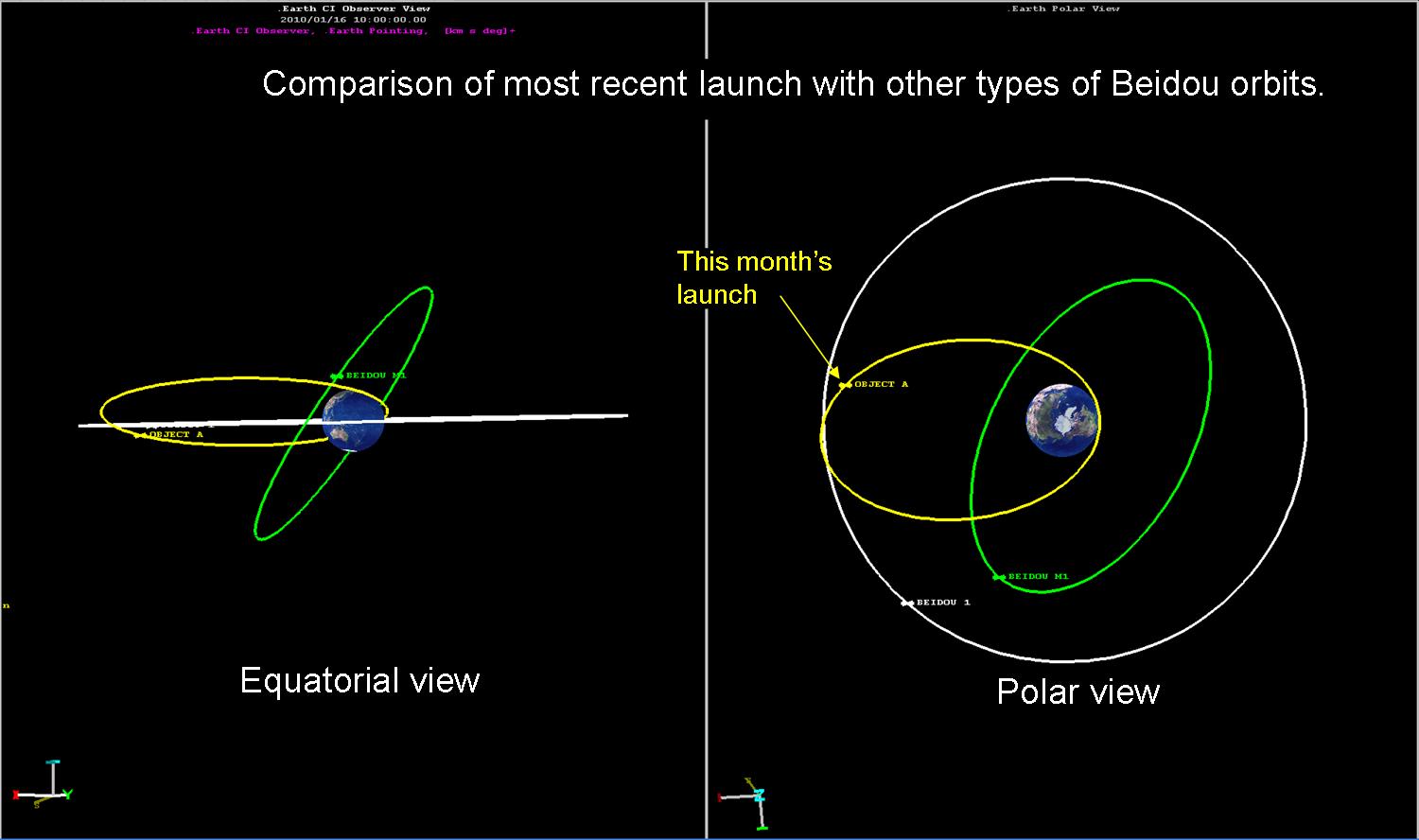
The most recent satellite reported to be joining China’s constellation of Beidou navigation satellites is shown in yellow. An example of a geostationary Beidou satellite is shown in white and China’s one and only navigation satellite in a medium Earth orbit (MEO) is shown in green.
The launch of what is reported to be a seventh Chinese navigation satellite (on 16 January 2010) provides an opportunity to review what we know about this system of satellites. First, it is clear that the satellite, which has yet not been officially designated a Beidou satellite on the NASA space-track website (at least as of 12 noon, 18 January 2010), is intended to be a geostationary satellite. It, and the third stage of the CZ-3 launch vehicle, are in a geostationary transfer orbit (GTO), as the image above shows. Within a few days of launch, the satellite’s apogee motor will fire, positioning the satellite in to its final orbital.
If the case of Beidou 1D is any indication, we will not know which satellite it is replacing until China moves it into position. China, as a responsible spacefaring nation, moved Beidou 1D into a supersync orbit just days after the launch of its replacement satellite, Beidou G-2. Beidou 1D as only about two years old when China replaced it with what is reported to be a second generation Beidou satellite. That is somewhat surprising since Beidou 1 was over six years old at the time and one might have expected it to be replaced before the much younger 1D. If China decided to replace 1D because it was failing, they must have had plenty of warning since they were still in control of that satellite.
click on the image for a larger version
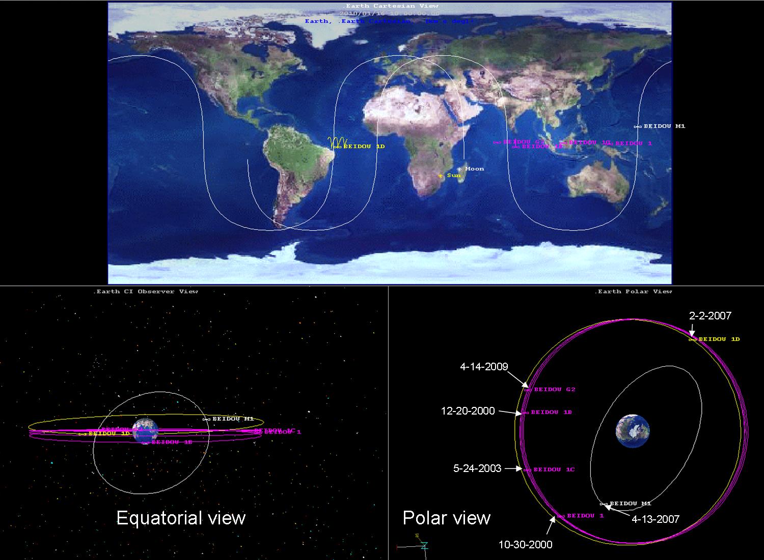
Current Beidou Constellation is shown (at the top) with the ground tracks for three orbits for each satellite projected onto the Earth’s surface; (lower left) an equatorial view of the satellites; (lower right) a polar view of the constellation. Note the Beidou 1D’s ground track shows both a large longitudinal displacement over three days and a large inclination—the up and down motion of the ground track. Dates indicated are the launch date of each satellite.
China’s first generation of navigational satellites did not have an onboard atomic clock. That, of course, complicated their operation and limited the number of users. Instead of broadcasting their own timing, as GPS satellites do, the satellite operated as a “bend in a pipe” with the time standard generated on Earth and, in fact, the “user” position determined by a central location after a round trip of radio signals from the center to the satellite to the user and back. It would be very interesting to know if the second generation satellites had their own space qualified atomic clocks.
With this latest satellite, we are also starting to see a pattern in Beidou launches. About every three years (2000, 2003, 2007, 2009*, 2010) a new wave of satellites is plugged into the constellation. (The asterisk for 2009 indicates that this launch might well have been accelerated to replace a dying satellite.) That might indicate the length of time it takes to design and/or build a new satellite. If it includes design time, I would expect evolutionary changes; something we might expect from China in any case given their known history of systematic development.

We shouldn’t forget that it was the Chinese who invented rockets in the first place.
> a round trip of radio signals from the center to the satellite to the user and back
Not what you want for several different kinds of security, need it be said. The user needs to be utterly, totally passive, which is what satellite-generated timing provides.
Ideally, the center should have nothing to do with the process either. GPS kind of does that, as the ground station is only involved for satellite updates and maintenance, not individual user transactions.
The Chinese are having to using ground-based lasers to synchonize the satellite clocks. This is because the Swiss atomic clock manufacturer refused to sell them the same accurate clocks used in the much delayed Galileo GNSS system and instead sold the Chinese atomic clocks that were three times LESS accurate. Kind of like handicapping the competition. I have no doubt that the Chinese are working on their own atomic clocks and will probably include them in later Beidou satellites after much testing.
To Allen Thomson,
The Chinese have a long tradition of observing products made by others, then instead of imitating them, they simplify and improve upon them.
Why would they make Beidou so complicated? It seems out of step with their cultural preferences. Do you have any thoughts on this?
> Why would they make Beidou so complicated?
If the two-way bent-pipe system design was motivated solely by desire for simplicity of satellite design and not by technological necessity(*), then it implies that the PRC was anticipating that Beidou will always be used in benign environments. No concerns about giving away user location, denial of the timing signal, etc.
(*) I.e., lack of space-qualified clocks of the required accuracy.
Allen,
You are not thinking of the first generation Beidou constellation from the proper point of view. It is designed to allow China to learn about space-based navigation. The first generation was far from an “operational” system though it had some interesting consequences for polar trajectories—where they could determine velocities very accurately. They will grow into the system as they learn more and develop autonomous satellites.