The Ports of North Korea
Yesterday, we started to get some ballpark numbers relevant to interdicting WMD shipments. Today, we are going to continue to try to get a feel for the problem of determining whether or not there is proscribed material onboard a ship. The first step, I think, is to considering the volume of shipping going into and out of North Korean ports. The larger the volume of shipping, the harder it will be to notice unusual activities. On the other hand, if there are few ocean-going ships, it will be much easier to keep an eye on what is happening. Tomorrow, we will (finally) get down to the question of actually observing the loading of ships. To jump ahead a little, it is going to prove very difficult to spot WMD related containers and the “reasonable grounds” could very well come from knowing where the ship is going. That will be the final entry in this series.
We (i.e. I) only have a snapshot of that shipping as presented by GoogleEarth though it does manage to convey an amazingly vivid sense of the North’s economy. ( If you need further confirmation of it, check out this image of the Korean peninsula taken at night. )
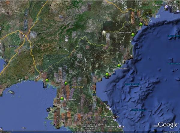
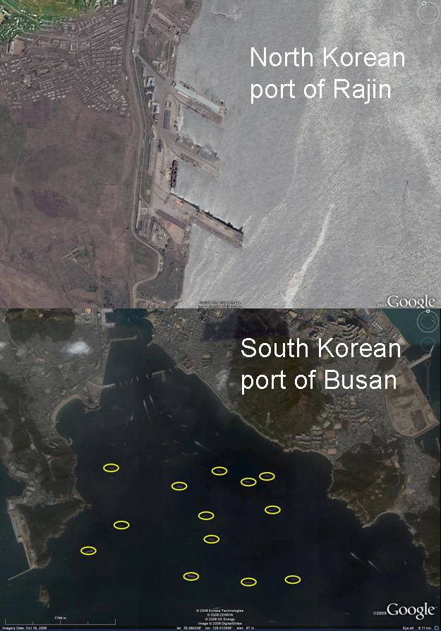
The GoogleEarth image above shows all the port facilities (and then some) found by North Korea Economy Watch . I have only seen evidence of large, ocean going cargo vessels at a couple of these: Rajin and Yuktae-dong (which NKEW labels Ship Construction/Repair),. Chongjin Shipyard and the other “ports” appear to be mainly coastal vessels with the largest ship I’ve seen measuring less than 30 meters long by 4.5 meters wide. If we assumed these could be ocean going vessels, then each one might hold four cargo contains or about 380 centrifuges as compared to the 61 cargo containers needed for a “standard” cascade interconnect bomb plant. It, of course, makes a lot of sense for North Korea to be emphasizing coastal vessels considering how mountainous the terrain is. Only Rajin appears (at least to on my search) to be the only one with port-based cranes for moving cargo. Yuktae-dong has large quays but the large ship visible has ship-based crane. That, of course, means that the other ports could be used by those ocean-going ships with their own cranes if the harbor is accessible to them. On the plus side, however, the North is missing a lot of the lovely crinkly bits, as Slartibartfast might say, that South Korea has and that might make wonderful temporary harbors.
Now, compare the Port of Rajin with the Port of Busan in South Korea. Busan has a ton of ships just waiting at anchor to get their turn at the docks to load/unload. I’ve circled just some of the 200+ meter long ships at anchor. I stopped when I got tired of doing it. This snapshot might be an even better way of judging the international trade of the two countries than the tonnage of flagged ships since the North and South have similar numbers of ships carrying their flags. The difference in harbor occupation is obviously made up of ships flagged by different countries. One thing the West has going for it in terms of following WMD shipping leaving or coming into the DPRK is, therefore, the dearth of ocean-going shipping. If an ocean going ship is detected, it might be easy to follow.
Of course, it might be very hard to discriminate the loading of WMD related equipment from, say, a load of pig iron. Perhaps the only clue might be the extra security associated with transporting centrifuges or other sensitive equipment. Depending on how efficiently the cranes are run, it might take up to five minutes for each container to loaded onboard though it could take considerably shorter. Of course, if they are loading an entire bomb production plant, this could correspond to up to five hours. All of which could be done at night with minimal lighting on the security force.
Tomorrow, we will consider the frequency of visits over the ports by photoreconnaissance satellites as well as viewing them from UAVs.

I don’t know how relevant it is, but the DPRK is a member of the International Maritime Organization and therefore (I think) subject to the International Convention for the Safety of Life at Sea (SOLAS).
Chapter V of SOLAS mandates that all cargo vessels > 300 tons gross weight carry Automatic Identification System equipment, which constantly broadcasts a ship’s identification, location, course and speed and other pertinent information.
To Allen Thomson,
Tracking ships would have to be a major task. And you obviously mean that this feature could be used to track the ships easier.
But the same feature could be used by “the other side” for misleading the “observers”. If you take the equipment out and leave it in port or have on board another vessel going on a routine or innocuous route while the real ship is on a “proliferation mission”.
Another thing with tracking systems like that, based on treaty obligations, is who receives the data from the system (is it here the IMO?) and whether this agency/organization that receives the data is also bound under the treaty or its statute by confidentiality. I guess it is.
Tracking conventional weapons shipments to terrorists such as Hamas and Hizbollah are easier in that conventional weapons consignments are going to be bigger and bulkier. There is also circumstantial evidence, ie what is a NK vessel doing in the Red Sea and so forth. Tracking say a small nuclear weapon in a container filled with crates of automobile parts is going to be a little more tricky unless there is a synergy of intelligence to kick into place before it goes FOB. How much more so regarding components and materials.
“Another thing with tracking systems like that, based on treaty obligations, is who receives the data from the system (is it here the IMO?) and whether this agency/organization that receives the data is also bound under the treaty or its statute by confidentiality. I guess it is.”
Location/name data is actually commercially available over the web.
I for one am somewhat surprised we haven’t heard of the much talked about Somalia pirates being busted with a satellite phone and a GPS unit to help them home in on a target ship.
AIS is actually primarily a ship-to-ship system meant to aid navigation and collision avoidance. It works by transmitting the ship’s location, course, speed and identification on one of two dedicated VHF channels at around 162MHz. Other ships within range can receive this data and use it to help watchkeepers keep track of traffic in the area.
Now, if a naval vessel was to stumble upon a freighter over 300 tons without an active AIS transmitter, or one transmitting false identification information, that would be very suspicious. I’d say that would be way more than enough to provide immediate “reasonable grounds” for any investigation.
By the way, AIS transmissions can be received through a run-of-the-mill radio scanner coupled to a standard computer running freely available software, such as ShipPlotter . Me too am surprised that the pirates haven’t been reported to use these things for their advantage.
> But the same feature could be used by “the other side” for misleading the “observers”. If you take the equipment out and leave it in port or have on board another vessel going on a routine or innocuous route while the real ship is on a “proliferation mission”.
True, AIS would be at best one component of a tracking system. As you say, it could be used for spoofing and would have to be checked by other means.
>who receives the data from the system
The AIS system is primarily intended for collision avoidance, so the ships carrying it continually broadcast and receive the data to/from other ships in the area. A VHF link with a nominal range of 50 nautical miles is used, but propagation to longer ranges is common. Also, an aircraft would be able to receive line of sight VHF from a ship at greater distances than another ship would.
See http://www.boatingsf.com/ais_map.php for a shore-based AIS application monitoring ships in the vicinity of San Francisco.