click on the image for a larger version
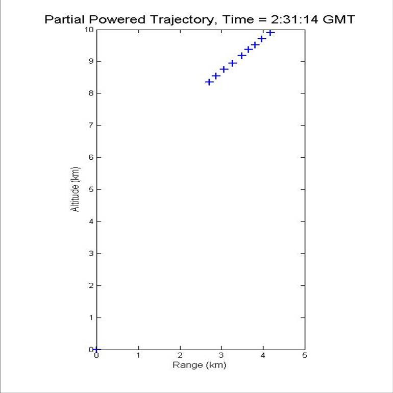
Or, to be more precise, 44 seconds. For those of you very few who can possibly muster enough interested in reading a third posting on this subject, DigitalGlobe has just told Globalsecurity.org the exact time the contrail image was taken: 2:31:16 GMT. (I have to thank Tim Brown and his colleagues at Globalsecurity.org for being so generous as to provide me with all this support. You guys are the best!) This 44 seconds difference in timing makes a big difference in the reconstructed trajectory. You have to remember that the Worldview-1 satellite is moving at nearly 7.7 km/s so it is 340 km closer to North Korea then previously thought. This changes the viewing angle enough to make the reconstructed trajectory much more consistent with various models. We will have to wait to see if those modelers can use this to tell the difference between ICBM trajectories or space launch trajectories.
Update: A number of people, including Wonk-reader Allen Thomson, have pointed out that in addition to the vapor contrail near the end of the trajectory imaged on the DigitalGlobe/Globalsecurity.org photograph, there is a “thermal contrail” extending much farther back to the launch point. Computer-wiz Jan Stupl who needed a break from writing what is going to turn out to be a ground-breaking paper on the Airborne Laser, did a contrast enhancement on it and made it clearly visible for nearly 3/4 of the way to the launch pad. Thanks everyone! I wont be reporting anymore intermediate results but as soon as I finish the complete analysis, I’ll post a link to it.

Love your posts. Keep up the good work.
A lot better now, Geoff! (David Wright beat me in pointing out that your initial trajectory-reconstruction was very shallow…well, but that was preliminary, wasn’t it?)
I’m very curious for the final version.
A certain peculiarity catches my eye: the height of about 8-10km is characteristically quite windy (and the wind-directions vary rather randomly with height), but the contrail in the one-million-dollar-snapshot (not one-in-a-million-probability, but certainly worth that amount of money…) obviously does not get blown around a lot (-> “frozen lightning”-phenomenon) – i think the North Koreans waited with their launch until the weather/wind-conditions were almost optimal (this could offer a plausible explanation for the one-day delay).
Thank you, Jochen. And I’m glad I don’t have to try to convince you that its a rocket and not an airplane anymore.
>including Wonk-reader Allen Thomson
It was another Wonk-reader who pointed it out to me off-line. I doubt I’d have noticed it by myself.
Geoff:
I hope you understand my skepticism early on; if you have no idea that this shot was taken at/around 60° slant angle (isn’t this supposed to be the maximum possible?) from somewhere above the east-chinese sea, absolutely nothing makes sense (plus the GlobalSecurity-page’s information was somewhat misleading – BTW: thanks for the correction, Mr. Brown) – neither the direction of the contrail nor the distorted shoreline (nor GlobalSecurity’s 102-minutes-figure – is this more like 10.2 minutes, which would still be somewhat short, or does this refer to something completely different than the splashdown-time of the upper stages?).
Could you reveal to me (and/or everybody else) the new set of WorldView-1-coordinates you are working with at the moment?