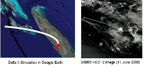
The image on the left is a simulation of the Delta II powered trajectory in GoogleEarth, the red portion is the solid rocket boosters; the image on the right is the actual SBIRS photo with the outline of Florida highlighted.
The US Air Force released the on-orbit checkout picture for SBIRS HEO 2 on 20 June 2008, showing in remarkable detail what that satellite, in a Molynia orbit, can do. I would say it was unprecedented, but the Air Force had actually released a similar picture that was published in November 2006, as I blogged about last Friday. In the November 2006 press release, the Air Force emphasized that the picture had been doctored by removing all the stars visible in the image so as not to give away which satellite the SBIRS HEO sensor was riding on. Unfortunately, there are few, if any, secrets in space! Amateur satellite observers had long ago determined which satellites SBIRS was riding on and had even determined their orbital elements. It turns out that Keplerian dynamics were declassified about 400 years ago. Perhaps the people responsible for our military space infrastructure should start taking that into account?
However, just knowing which rocket launch was being imaged allows us to say quite a bit about the capabilities of the sensor, though perhaps not the minimum thrust detectable by the system; something I wont even attempt to do. Since the image was released on 20 June 2008, we can look back for US launches that took place shortly before that and see that the most likely target was the 11 June 2008 launch of the GLAST scientific satellite which went into a nearly circular orbit with an inclination of 26 degrees from Cape Canaveral onboard a Delta II 7920H. That orbital inclination corresponds to a launch azimuth of 90 degrees. From the publicly available information about the Delta family of launch vehicles, we can determine the timeline of important events for that launch and, in fact, simulate its trajectory with a high degree of certainty. These events are listed as the first comment in that section of this blog.
Simulating the GLAST launch helps identify the various phenomena discussed in the previous blog as well as the area of the Earth’s surface visible in the image. It appears to me that the outline of Florida is clearly visible in the image as is, perhaps, the Grand Bahamas Island. (I can’t be as sure about that later identification.) The SBIRS image clearly shows many of the phenomena we discussed yesterday. My identification of these features are shown in the picture below; what follows is a more detailed discussion of them.
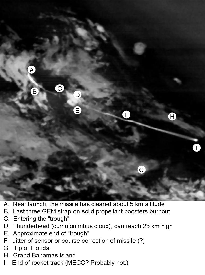
click on the image for a larger version
(note that this image has been rotated 180 degrees from the images above, so that the track starts on left and ends on the right.)
A) The Delta II 7920H has a total of nine strap-on GEM solid-propellant boosters. Six of them are lit on the ground after the main stage, or core, liquid propellant engines are started. Three are lit while the rocket is in the air, at 66 seconds into the flight and about 14 km up. These solid-propellant boosters have, as do most modern solid-propellant motors, a high component of aluminum mixed in. This serves to increase the combustion temperature inside the motor casing but as come out the nozzle as fairly large globs of liquid aluminum (on the order of 100 microns in diameter). This molten aluminum continues to oxidize after leaving the nozzle and helps produce this very bright segment of track. The main core liquid-propellant engine, which burns LOX and kerosene, probably has a very complete combustion inside the chamber. However, it does contribute to this part of the track if for no other reason than the reheating caused by shear-shock as it exits the nozzle and hits the surrounding atmosphere. The last three strap-ons burn out at about 68 km altitude (marked by B in the image).
B-C) This segment of the track is caused by the core first stage, with the predominant portion caused by the shear-shock reheating of the exhaust.
C-E) The missile has entered the “trough” region where plume brightness is minimal, at least partially because the exhaust gases come out of the nozzle almost at rest with respect to the surrounding atmosphere. (In other words, the rocket is moving at the speed of its exhaust gases and they enter the atmosphere almost at rest.)
D) This is almost certainly a thunderhead that has risen so high (some can reach 23 km) that it can reflect a lot of sunlight back to the sensor. There are no significant events in the rocket trajectory at anywhere near this time that could account for a missile generated event. If it is an illuminated cloud, it has been “integrated” over some 200 seconds by adding a whole series of frames together. Each individual frame from SBIRS would show a very low intensity cloud image here and the rocket exhaust plume would be considerably brighter, eliminating the problem seen here of tracking across the cloud.
F) The rocket has left the “trough” region and its exhaust is being reheated by the collapsing shockwave as the atmosphere rushes back into that space. There appears to a significant cross-track movement to the trajectory here. The things that occur to me are either jitter in the sensor—it has to keep pointing accuracy to something on the order of 14 microradians over several hundred seconds in this case—or it could be that the missile actually made a significant course correction here. Of course, the satellite does not need to point to that accuracy, it just needs to hold the image that still either mechanically, by a steering mirror, or digitally by adjusting some guide pixels. Both of these techniques have become familiar to owners of digital cameras in recent years.
G and H) G is almost certainly the tip of Florida and I have come to believe that H is the Grand Bahamas Island. The background, which has remained stationary in the frame, has been essentially “integrated” over some 200 seconds. This has allowed the very faint ground image to show up.
I) This is the end of the track shown in the image. Since the rocket coasts for some 10 seconds (which would correspond to some 450 km) it is not a brief increase in luminosity showing up as the second stage plume hits the first stage as it falls away. In fact, I am not 100% convinced that it is even the end of the first stage firing. It has proven very hard to get a good match up between the SBIRS image and the GoogleEarth position so I cannot say with certainty that it corresponds to MECO (Main Engine Cut Off). On the other hand, there is a definite increase in brightness that could be associated with MECO, though what exactly, I don’t know.
Tomorrow, I will look at the other SBIRS image, which shows the limb of the Earth in the field of view and very bright clouds. While it too has been integrated over several hundred seconds, it shows another reason why it is good to look at missile launches in stereo, and not just for tracking! See my CATO paper on Russia’s space-based early warning system and in particular, what I call the Autumnal Equinox Incident that almost started a nuclear war between the US and the Soviet Union.

Delta II 7920H Launch Event Timeline:
Launch: t = 0 s
Burnout of 6 GEM-46 strapons: 64
Ignition of remaining 3 strapons: 66
Drop off of first 6 GEMs: 86
Burnout of remaining 3 GEMs: 130
Drop off of remaining 3 GEMs: 132
Main Engine Cut Off (MECO): 264
2nd stage ignition: 274
2nd stage engine cut off: #1 (SECO-1): 617
2nd stage re-ignition: 1237
SECO-2 1306
Really enjoying these posts, Geoff.
I’m probably asking a dumb question here, but since rocket plumes are selective emitters and thus vary due to propellant, is SBIRS able to differentiate between differing rocket types (and aircraft exhausts?) through their emission spectra?
Nik—
Thats a very important question! While I believe SBIRS (and DSP) only looks at the light from a single wavelength band, it is still possible for them to analyze the type of missile being launched by looking at the trajectory: its total length, estimating its speed, and other characteristics that Ive discussed. However, it certainly helps for the operators to have seen the missile before and to have loaded an expected trajectory pattern into their computers. Because the accuracy of all the quantities increases with the numbers and frequency of observations, SBIRS should be considerably better at it, and at gaining intelligence of missile proliferation developments, than DSP is because its “revisit” rate is considerably greater.
DSP seems to have a second band, at least in the newer models. I’d be surprised if SBIRS didn’t also:
http://tinyurl.com/5z4qfr
DSP Satellites See Aggressive New Chinese Missile Testing
AWST
Apr 8, 2007
By Craig Covault
“A portion of the [DSP] high-resolution detectors are optimized for “above-the-horizon” rocket plume signatures against the blackness of space, as well as other detectors, to obtain data against water, terrain and cloud backgrounds. A dual color/second wave-band capability in the 4.3-micron bands helps protect DSPs from laser jamming. It also enables the DSPs to monitor more modern missile low-exhaust plume intensity.”
BTW, there are two interesting articles on DSP at
http://www.aero.org/publications/crosslink/summer2000/03.html
and
http://www.aero.org/publications/crosslink/winter2000/01.html
SBIRS High (It’s not clear to me how similar the SBIRS HEO and GEO sensors are.)
http://www.afspc.af.mil/library/factsheets/factsheet.asp?id=3675
SBIRS HIGH
“SBIRS High features a mix of geosynchronous earth orbit satellites, highly elliptical earth orbit payloads, and associated ground hardware and software. SBIRS High will have both, improved sensor flexibility and sensitivity. Sensors will cover short-wave infrared like its predecessor, expanded mid-wave infrared and see-to-the-ground bands allowing it to perform a broader set of missions as compared to DSP.”
A minor detail on the GLAST launch: NASA gives a launch date of 11 June 08, not 14 June as in the text of your post or 14 March as in the label on your image.
I checked the date because I thought I’d have a look around for weather sat images that might confirm that the SBIRS image is indeed of that launch. The best I could find without any special access to archival collections were pretty low-res and off by about 2 hours (e.g., http://www.satmos.meteo.fr/qkl/ameriques/2008/2008-06/2008-06-11/2008-06-11_g4g/goes12_g4g_1800.jpg), so I doubt you can conclude much from them. It is perhaps possible to say that the weather patterns shown are not so different as to exclude the possibility that the SBIRS image is of the GLAST launch. Higher res images from the right time of day might clinch the issue.
Thanks Bill! Strangely enough, I actually used the correct date in my simulation but it somehow didn’t propagate into the text. You can see a movie of the launch at
http://www.nasa.gov/mission_pages/GLAST/launch/HD-Launch.html
which clearly shows that it was a cloudy day, though you cant see individual thunderheads etc.
Thanks, Geoff and Allen for the replies,
I only asked the question regarding identification from emission spectra since i was aware of two possible transmission windows around 2.9 and 4.8 (ish) and it seemed logical that SBIRS would use any available windows for target identification. With these two relatively wide windows to analyse i imagined some sort of rocket motor identification could be attempted. But i don’t know enough about rocket motors etc to know if this is actually useful in identifying the actual missile that uses them.
Of course, i always thought that DSP was primarily for identifying SLBM launches and nuclear tests and there’s not many things you can confuse them with.
Thanks.