Sean O’Connor, whose excellent IMINT and Analysis blog was recently on hiatus, sent along his thoughts on the Box o’ Burma, aka The BOB:
Recent revelations in Sydney Morning Herald and Yale Global Online (Part I and Part II) have begun to shed more light on the potential nuclear ambitions of Burma. While it is known that an IAEA monitored, Russian-built research reactor is being constructed near Myaing, reports from defectors have surfaced claiming that a second nuclear facility is being created. This second facility, reportedly near Pyin Oo Lwin, is allegedly being constructed with the aid of the DPRK, Russia, and possibly Iran. It is the cornerstone to the Burmese clandestine nuclear weapons program.
Burma’s nuclear program is allegedly composed of two facets: a nuclear plant and plutonium reprocessing center, and an artillery unit, which may eventually be equipped with ballistic missiles imported from North Korea. The entire complex is believed to be placed within the Setkhaya Mountains, southeast of Pyin Oo Lwin. Burmese scientists and soldiers have traveled to Russia for training in the operation of nuclear reactors, as part of the Burma-Russia program to develop a research reactor near Myaing, and reports suggest that some personnel have traveled to North Korea for similar reasons. North Korea appears to be the source for the bulk of the design and infrastructure development for the reactor and reprocessing plant. The reactor is believed to use water to provide the carbon dioxide used in the cooling loop. This is consistent with North Korean reactor design, and both the reactor at Yongbyon and the alleged reactor being built in Syria were sited near water sources for this reason.
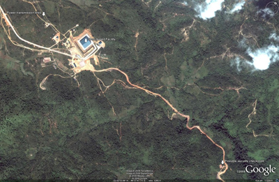
Recent analysis of satellite imagery has brought a potential location for Burma’s nuclear program to light. The facility, roughly 10 miles east of Pyin Oo Lwin, can be seen in the image below. This facility was under construction in 2005 when the imagery was captured, which would make it a candidate for the covert nuclear program but not the civilian program supported by Russia, which had not yet seen any significant activity in 2009. Three key points are annotated in the image, the facility itself, the power transmission lines which can be traced to Anisakhan southwest of Pyin Oo Lwin.
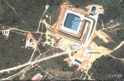
A detailed view of the main complex itself is provided below. Many features of the complex can be discerned even though it is still clearly being constructed. Note the aforementioned power lines, and the fact that they terminate at a substation, likely providing electricity for the complex. The main facility appears to be situated in a shallow revetment carved out of the terrain, with a smaller complex overlooking it from above. There are signs that fencing is being placed around the revetted facility, and signs that further buildings and roads are being constructed. The main facility, measuring 82 by 84 feet, appears to have a slanted, inverted v shaped roof made of corrugated metal.
There are numerous aspects of this facility which suggest that, while it may have some part to play in Burma’s nuclear program, it is not the site of the covert nuclear plant or reprocessing center. Firstly, recall the cooling requirements for a North Korean reactor design. There is no indication of any nearby source of water, or any significant piping from such a source, to provide the necessary water needed to cool the reactor. It was reported by one of the defectors that North Koreans were present at the covert site to engage in significant tunneling projects, as the reactor and/or plutonium processing plant were allegedly to be placed below ground. No sign of any sort of tunneling is present, or at least was not present in 2005. Furthermore, the terrain where the building is placed, as seen in the image below, does not preclude a large degree of tunneling or UGF emplacement. While there is a degree of terrain variation, it is not of sufficient depth to allow for UGF construction without boring down into the Earth at an angle, and thereby producing a much more noticeable construction footprint. Also, the facility does not appear to be sunk into the terrain to a great degree, disqualifying its use as a portal for entering a buried UGF.
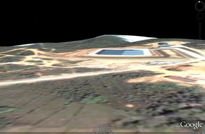
There are two interesting features which may indicate where the covert facility, if it exists, will be sited. First, the access road leading to the east into the terrain is a new construction, and it leads right past the second feature, a possible security checkpoint. This is the first major security-related feature present in the area, and suggests that whatever is being concealed is further to the east. In fact, it has been suggested by a Burmese security officer that the “Naung Laing” (an alternate name for Pyin Oo Lwin, as well as Maymyo) facility is merely a distraction meant to hide the location of the real facility. While this is not necessarily likely, lax security noted in the area as of late suggests that the officer was at least half correct: this is not a nuclear facility. The likely location for the covert site is further east, near the river. An area of interest (AOI) for future investigation has been marked on the following image:
This location has a number of advantages:
– Preexisting, convenient water source for cooling
– Deeper and more varied terrain for UGF construction
– Conditions more amenable to the formation and persistence of mist, a feature claimed by defectors to have been chosen so that work on and the presence of the facility (and potentially cooling emissions) could be hidden from the air
As demonstrated above, while the unidentified facility located in Burma may not be related to the nuclear program, it does represent an interesting enigma, and its presence may have provided enough information to locate the general position of the covert site. The most likely explanation for the U/I facility, apart from the previously mentioned decoy site, is a support function for the significant amount of tunnelling which must be undertaken in order to construct the UGFs required by the project. In time this may even represent the security and site support base for the facility. Further investigation and analysis is required, but it can be stated with a degree of certainty, given the evidence and information at hand, that no nuclear activity will be undertaken underneath the 82 by 84 foot roof.

Hey Jeff – A couple of points.
From the way the shadows fall, I would say that the roof is a normal pitched roof and agree that it looks like corrugated metal.
The “sideways” image, however, probably adds no information at all because it is simply a transformation of the overhead image, as I explained here. There may be some terrain elevation information added in, but the building clearly is from the overhead, and therefore the excavated terrain around the building is likely a simple transformation of the overhead, no additional information to interpret there.
It would be nice to see the dirt pile from excavation, but it would also be an easy thing to distribute that dirt in the jungle.
2 points on O’Connor’s analysis:
1. Roof shadow on north side shows normal, center peak roof not inverted-V.
2. 82 meter square, not foot.
My own review… Something was bugging me about the building itself, looking at it. I had assumed that there was a drainage ditch dug around it, below natural grade, and that accounted for the stepped appearance of the surrounding dirt. I think I was wrong.
I had been assuming that the hill to the east was a sharp up-grade – that the two parallel access roads on the east, one of which goes “past” and to the small rectangular building about 75m northeast, was “uphill” from the road going to the BOB itself.
I was looking at clues and now I think I had that backwards – I think the site is fundamentally more flat, that the LBB to the northeast is at the same grade roughly as the entrance road past the berm areas. My current read is that the building sits on top an artificial, two-step step pyramid type dirt structure, with the access ramp to it sloping up as it heads northeast, then level with the facility as it makes the 90 degree turn to the northwest and across to the cement pad around the building.
The 2-step dirt structure has very linear, squared off sides, and the bottom of the outside seems to be “at grade”.
That is very, very odd.
If I am interpreting the topology correctly, if those steps are 45 degree slopes, then the concrete pad is on the order of 15 meters above surrounding grade.
I can think of no good reason to place an ordinary building up on a raised pad like that.
The only purpose that comes to mind is building an earth-covered structure inside an artificial mound, and disguising it by putting a normal-looking warehouse type building on top. Presumably, there’s an access ramp back down inside somewhere under the BOB roof.
The only type of facilities worth doing that with that I can think of would be nuclear or military command and control.
So, challenge for other readers – look at the site topology with me. Let’s try and figure out – is that a step pyramid up, or am I misreading the site topology.
I agree with O’Connor that a bigger facility further east, off the Google Earth detailed image patch over by the river to the east, is more likely a primary facility. But I am no longer convinced this facility is relatively innocent.
I don’t know what BoB is for, but O’Conner is basing part of his analysis upon a false assumption.
Significant supplies of water for cooling a reactor and/or reprocessing facility are not a sine qua non.
This is particularly so for a low power plant like the Syrian LEGO factory, or the NK bomb machine.
An array of dry forced air heat exchangers are certainly effective.
Working exactly like a car radiator, the hot reactor water from the secondary loop is pumped thru a grid of finned tubes. Large fans pull cooling air thru the grid. The now cooled water circulates back to the primary CO2/Water heat exchanger exchanger at the reactor.
If you have a good source of cooling water like a river or lake, then fine, you save big bucks on electricity, but if you’re in the desert or mountains, and cost-effectiveness is not primary, then dry cooling is fine.
> So, challenge for other readers – look at the site topology with me. Let’s try and figure out – is that a step pyramid up, or am I misreading the site topology.
(I sent this in e-mail a bit ago, but repeat it here. As always, FWIW):
I should have done this before, but the Google Earth terrain tool indicates that the BOB was built on a site that sloped up by twenty meters or so from the south to the north edge. If that’s so, they had a fairly serious amount of leveling to do by cutting down the north side, building up the south, or some combination of the two.
1/4
For those of you with a life, you can skip my verbal diarrhoea below – I haven’t a clue what this building is.
For those of you who want to read further – you should get out more, and maybe also get some professional help! 🙂
When I look at Google Earth I’m struck not just by what this thing is, but also where it is. As I’m sure you’ve all noticed, Pyin Oo Lwin seems to be in the heartland of the Burmese military. For example, there’s a spanking great 3000m airfield just southwest of the town, which clearly can’t be for tourism because there’s a 4000m one about 50 km southwest, near to Mandalay. There’s also the Defence Services Academy (nicely marked with a link to Wikipedia) at 22 01’ 26” N and 96 27’ 57” E. And a nice golf course nearby (22 00’ 33” N, 97 27’ 44” E) and some pretty plush housing at 21 59’ N, 96 26’ 40” E. Given the look of the DSA, I’d also guess that the regular structures around 22 00’ 00” N, 97 27’ 00” E are a barracks. Oh, and there’s also the Governor’s house at 22 01’ 06” N, 97 27’ 26” E.
As an earlier poster pointed out, NIMBYism is surely as valid in Burma as anywhere else, so already I start to have doubts about the structure being a secret MAGNOX-type reactor, which could be bombed at any moment (if we’re to believe the explanation of the BOE). Nonetheless, placing BOB only 20 km from such a collection of military nobs and hob-nobs, suggests two things: Either the Burmese want the protection afforded by having several thousand soldiers and trainees nearby, or else they wanted to put it somewhere where any unusual activity would be invisible against a background of regular military flights, convoys, checkpoints, detachments of soldiers marching hither and thither, etc. My money’s on the second option: BOB is where it is (i.e. near to Pyin Oo Lwin) because it would be more difficult to distinguish BOB-related activities from the regular comings and goings of a military town.
As to what it is, your guess is as good as mine. Based on the Google Earth photo I don’t believe at the moment that it is a reactor. Yale correctly says that “Significant supplies of water for cooling a reactor and/or reprocessing facility are not a sine qua non” for a reactor. But the alternative of using air-cooled condensers just doesn’t strike me as credible. Air cooled condensers are enormously less efficient; you’d be doing well to get a hotwell temperature of 60 deg C with air-cooled, compared to 33 deg C with water cooled, meaning that if a putative reactor has a core-coolant circulation of about 100 kg/s then the water-cooled version could run at a thermal power about 10 MW higher. On a reactor that’s only 40 – 50 MWth anyway, that’s a big difference.
2/4
Not only are air-cooled condensers less effective, but they are BIG; they’d be very visible from the air, and you could easily see what temperature they’re running at, and thus deduce, from their surface area, what heat load is being dumped to the air. This would tell you a lot about the operation, and maximum capability, of any reactor. On the engineering side, air-cooled condensers tend to foul easily in tropical regions, meaning they rapidly lose performance, and they’re also rather susceptible to the effects of wind, meaning that you can’t always achieve design load because of the wind. It’s bad enough running a combined-cycle gas turbine with air-cooled condensers, but I certainly wouldn’t want to operate a nuclear plant with one, because constraints and variations in my cooling would feedback to core reactivity, with consequences for plutonium production. If Burma really is building a MAGNOX type reactor then I think it would make far more sense to site it near a river and use once-through cooling (it would also be easier to hide the thermal signature by mixing excess river water with the condenser discharge, before pumping it back under the surface of the flowing river).
3/4
Regarding the “sub-station” at 23 03’ 01” N, 97 37’ 37” E, for what it’s worth I’d say it is a 132 kV station. Two years ago there was a Franco ASEAN seminar, which included a country report by Myanmar on its electrical grid (try googling “Powering ASEAN: Technology and Policy Options” and “Country report of Myanmar”; but if all else fails I could send a copy of the report to Jeffrey for posting). Slide 34 of the report shows a 132 kV line connecting Mandalay to Pyin Oo Lwin, so it would make sense if that supply was extended to the BOB. I don’t think the supply is 66 kV or 33 kV because the shadows of the pylons, and the lines (inasmuch as they are visible), around 23 03’ 40.5” N, 96 35’ 54” E suggests towers with lines on both sides (i.e. double circuit). That suggests to me both the higher voltage, and a certain amount of redundancy (for example, the Burmese could have just installed a single-circuit 33 kV supply if that’s all that was needed). If we accept – based on the Google earth photo – that there’s no indication of any major cooling, then the power lines are probably bringing power in rather than exporting it out.
Lastly, the earthworks are interesting; surely they haven’t been built just so that ACW readers can’t get some nice, sharp shadows for deducing the height of the building! 🙂 I presume that there is a reason for the earth bunds / berms, but I can’t think what it might be. Similarly, the road heading off into the very blurry neighbouring photo (at 22 02’ 52” N, 96 38’ 54” E) was presumably built for a reason; it’s just a shame we can’t follow and see where it goes. I also wonder if the structure at 22 02’ 56” N, 96 38’ 56” E is some kind of a checkpoint?
4/4
All in all, I see a large building close to a very militarised area, where it looks as if the access roads to the building are guarded by checkpoints. The building itself is surrounded (sunk into?) earthen berms, with access by a wide road up a ramp, with a 90 deg turn at the end. There’s no obvious source of cooling (if it is some kind of reactor / power station), yet there seems to be a twin-circuit grid connection to the site (possibly 132 kV, but likely to be at least 33 kV). 33 kV could plausibly be for lighting and HVAC in such a large building, but 132 kV would imply that something inside is consuming a lot of power.
If someone put a gun to my head and said “It’s definitely proliferation-related; now make a guess” then I’d go for a centrifuge installation. But in comparison to Natanz the whole footprint is too small. Quite frankly, although it’s suspicious I’m not at all sure that it is proliferation-related. As I said at the beginning, I haven’t a clue what this building is.
It’s worthwhile to look at the location of the building in the terrain and satellite views in Google Maps. It’s built into the lower slope of a hill in what, for lack of better, I’ll call an embayment in the surrouding, higher topography.
Like everybody else, I don’t know what it is, but would recommend caution when accepting or rejecting hypotheses.
In the NYT picture of the same building, it shows a river within at least a mile of it, Im now confused why you say its not close enough to water?
Just linked over from Kristoff’s article, don’t know much about nuclear sites but have learned a lot already.
Question: why the blue color? Looks like a swimming pool.
What about an ICBM silo? It would be a lot cheaper to simply buy a weapon from NK than to build the infrastructure and make one themselves. Could the power be to run a liquid oxygen plant for the ICBM? Liquid fueled rockets are too fragile for “real” military utility, but as a deterrent for a rogue state they might be “enough”. NK’s longest range missiles are liquid fueled.
Putting it close enough to all the military stuff would protect it from ground forces, but it is far enough away from military housing that if (when) it is attacked by precision munitions those in the military housing are not at risk.
Look at the turn radius of the access roads. What does that imply as to the length of what ever is going to be trucked to the site? The recent spate of testing by NK might be part of their marketing effort, to demonstrate they have something to sell.
The use of air cooling is not unrealistic. The Israeli reactor at Dimona is in the middle of a desert and uses air-cooled cooling towers. The temperature of an air-cooled cooling tower is easy to measure, but the air flow is not. One can easily make a big dry cooling tower and then not blow much air through it to give the illusion of a large power dissipation.
This is clearly a pyramid with an above ground area topped with a blue pitched roof, that is clearly above the tree line. All major activity will take place in the pyramid.
The smaller building to the back is not above it but below it with a smaller building in front of it. A car sits in between the pyramid and the building showing that the two buildings are far below it. What is missing is any entrance to or from any of the buildings connecting them to the pyramid, indicating underground access. The ramp is not a road but probably the base for an above ground pipeline or is for an already built underground pipeline. The river is close enough if the water is being pumped underground. There is far too much focus on the blue roof being on a singular above ground building. It is the highest point of the entire facility that is below it in the pyramid and who knows how much farther down into the earth it goes. Being close to a militarized area provides the highest protection. I only see at this point maybe one building that could be barracks. So only a few will be on site at any time for internal security. External will come from the nearby military area. This BOB could very well be nuclear.
This is a common or garden, prefabricated, square metal building (no “pyramid”), surrounded by parking (@ the same level as the driveway), and further surrounded by planted berms.
Where are the control points, guard houses, and alternate routes in and out?
If this is a nuclear, or military facility, I’m a monkey’s uncle.
Looks like a luxury resort, to me.
I agree that the roof is a normally pitched v-roof. It is 82m x 82m, and at the north entrance(?) is an ~6m long object, possibly a vehicle.
The longest vehicle you could move up the ramp would be something pulling a trailer 18-20m long judging from the curvature of the ramp. Futhermore, the ramp is 10-12m wide, whereas the road leading to the site is only about 5m wide. Does this suggest that they could be expecting to build larger items on site before moving them up the ramp?
There is a flat graded site 50×50m SE of the building – could this be a helipad or a site for another building? The other buildings are smaller, but still substantial 30m20m and 25mx8m.
Finally, the site is only 6km from the river, which would mean piping in water would be easy. A large enough pipeline could be constructed in only a month or two. However, at the time of this photo there is no evidence of a pipeline or pumping station near the river.
While Hairs points out Yale correctly says that “Significant supplies of water for cooling a reactor and/or reprocessing facility are not a sine qua non for a reactor“, he writes that the alternative of using air-cooled condensers just doesn’t strike me as credible.
I would rather say that 100% air-cooling is unlikely, but credible.
Remember what my original point was – that lack of convenient sources of water should NOT be overly depended upon as an indicator of nuclear facilities.
A proliferator makes choices that necessity requires. Efficiency, cost-effectiveness, reliability, etc. may not always apply.
Saddam’s uranium enrichment program was missed because no one thought that he would use the clunky, massive, and terribly wasteful obsolete technology of calutrons. The Iraqis were circling into getting mastery of the process when the Gulf War aborted it.
BTW – I don’t have any reason to think that BoB has any atomic facilities, just that lack of water does not completely preclude it – a more general obsevation.
Be that as it may, dry cooling is not the only water-scarce option. If the fan-cooled heat-exchangers are sprayed with a minimal amount of water, efficiency skyrockets. The water film is tremendously more efficient transferring the heat and much energy is carried away by evaporation.
These coolers can use more than 95% LESS water than comparable open water systems. This quantity of water can be piped (as Cam pointed out), drilled or hauled in.
Dimona in the Israeli desert and Khashub in Pakistan (about 4 km from the nearest large water source) appear to use these:
Khashub:
Dimona overhead:
Dimona side view (blowers in the center of picture):
Continuing..
From *Environmental Impact Assessment Report
New Nuclear Power Plant in Lithuania
August 27th 2008* EIA report by Pöyry Energy Oy (Finland)
Lithuanian Energy Institute (Lithuania)
Dry cooling methods
Specific features of an air-cooled condenser (ACC) and Heller system are insignificant make-up water consumption but also rather ineffective cooling. However, under circumstances where water is not available these cooling methods can be a reasonable solution despite the greater investment costs and the demand of large area.
ACC uses air as the cooling substance. The low-pressure steam from the turbine is led to the condenser, which consists of numerous finned tubes, usually mounted to an A-form. The steam condenses to water inside the tubes and cools down to the design temperature. The cooling occurs with convection and radiation. The air circulates through the condenser by fans, which require electricity. Because of the large diameter of the low pressure steam pipelines, the condenser must be located near the steam turbine. Due to relatively low heat transfer efficiency, ACC also requires a large area to be placed.
Heller is an indirect dry cooling method. There’s a closed circulation between the condenser and the dry cooling tower whose structure is very similar to ACC’s. The condenser is jet type which sprays the cooled water directly to the boiler water circulation. Therefore the cooling water has to be demineralised water. As the condenser is at vacuum, the cooled water from the tower is expanded at a regeneration turbine which regenerates a part of the pumping power needed for cooling water circulation.
=========================
An EXCELLENT fully illustrated overview of existing dry-cooled power stations can be found here
‘Hairs’ posted:
“…there’s a spanking great 3000m airfield just southwest of the town”
Take a careful look at this structure, at 21°59’19.49“N, 96°26’28.55“E about 8 miles SW of Pyin Oo Lwin. At low zoom it looks like a runway, and if you zoom in on it there appear to be very faint runway markings: centerline, fixed distance (500’ 1000’ 1500’ 2000’), but no identifier (eg. compass heading). These markings look way too faint to be of practical use, especially flying IFR.
Speaking of instrument flight, I find no visible evidence of navaids, approach lighting, tower – heck, not even a windsock. The ‘runway’ is about 10,000 feet long, according to Google Earth, but has no taxiways, turnoffs nor, assuming it is still under construction, any grading to prepare for adding them. The only ramp area is a small pad near the south end that could probably only accommodate a single wide body cargo jet.
And the single weirdest thing about this “airport” – no aircraft visible on the ground!
There are other oddities if you look for them. However, despite the faint markings, it is striking that what it reminds me of is not a runway, but the covered 2-mile-long shed that houses SLAC (Stanford Linear Accelerator Center). Could Burma possibly be trying to do some basic physics research? This is of course far-fetched, but overall it seems hard to explain what this installation is.
It’s an airstrip intended primarily for executive travel. I believe it’s the one the Indian defence minister flew in on a few years back.
Apologies to Yale and others: I agree that air cooling is “credible” (in the sense that it is technically possible, and has been done before) though unlikely.
In any case, I think the point is moot: The lack of any obvious provision for cooling i.e. no indications of piping or pumps at the river, no hardstands for cooling towers (whether air or water), no indications of LP steam pipes going in / out the building, all suggests that this is not a reactor. The lack of cooling may also rule out BOB being a chemical weapons factory too, although here my knowledge is tiny and I am on very shaky ground.
The limestone road seems to have fairly fresh limestone on it and it extends some distance from the site. The limestone had to come from somewhere and I don’t see a quarry anywhere in proximity to the site. My assumption is that it has come from a hole under said shed roof and has been distributed along the road. The road is pretty suspicious as it is quite wide and and well made and leads nowhere.
There is an intriguing series of squares on the ground, each with four smaller squares inside, commencing at the walled building (another substation?) at 22.110515°, 96.614832°. Some of these features have elaborate roads built to them. Here are some examples as they lead to the south of the airport at Anisakan and into the low-res area: 22.098502°, 96.605272°; 22.089592°, 96.598239°; 22.073161°, 96.586298°; 22.066907°, 96.575194°; 22.057571°, 96.563067°; 22.053335°, 96.544739°; 22.052184°, 96.539779°; 22.051508°, 96.536936°; 22.029315°, 96.521720°; 22.012443°, 96.512148°; 22.007270°, 96.509487°; 21.983725°, 96.495744°; 21.982472°, 96.476372°; 21.918012°, 96.392498°.
They could be construction sites for future powerlines, although the idea of ventilation shafts for a tunnel did cross my mind.
Compare their size to the existing powerlines to/from the main facility, which are on a much smaller scale, e.g. 22.062015°, 96.590979°. I can’t trace these all the way to Anisakhan, only to 22.061568°, 96.528988°.
JJ above fell for the same optical illusion I did, sort of an earthen step-pyramid up above a mostly flat surrounding terrain.
This is a goof, as topology and other sources available now indicate. To illustrate what I mistakenly saw at first close look, and the real topology, I created this graphic:
http://www.retro.com/employees/gherbert/Myanmar/Topo-Goof.png
I have cross sections roughly W-E and N-S for the mistaken “pyramid” topology, and the actual “cut into hillside” topology which the other sources including better read on the slope and hill heights support.
In relocating entire Myanmar Government from Yangon to Nyapyidaw, the Burmese (soldiers) Tatmadaw built a luxury beach resort for their higher ranked military and SLORC/ SPDC staff and APPARENTLY sited it in a location way up in the hills and near Mamyo (Pyin OoLwin)- with all the trimmings of a beach resort but away from the traumatic potenital of coastal living – they imported sand, created a fake beach, sailing, imported chinese beach umbrellas, deck chairs opened cafe serve cocktails etc etc In absence of other validity it may well be that Frank’s surmisal of these google earth photos depicting a luxury resort is a pretty accurate description – Daw ma khin aye 11 August 2009 1400 hrs