click on the image for a larger version
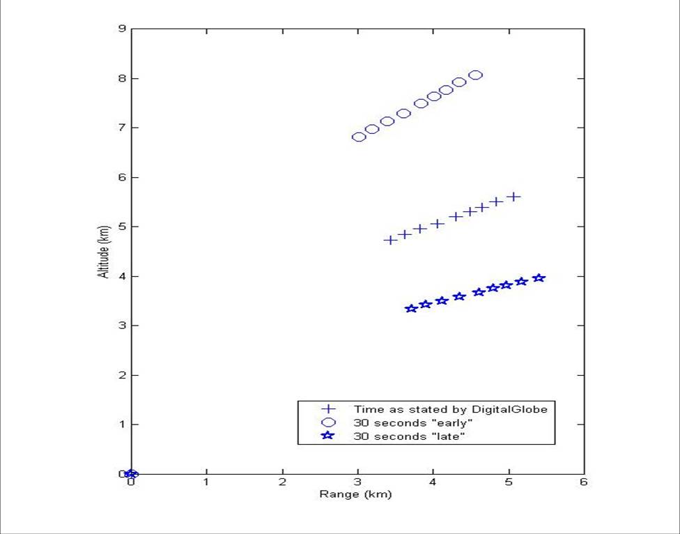
Unfortunately, there was a mistake in the range of the original plots. (These things happen when you rush to get things put up on the blog as soon as possible. Im sorry about that!) The observed pitch angle is still very shallow but less so that I originally thought. However, I am still of the opinion that this trajectory is more consistent with an ICBM type flyout that tries to maximize range than a space launch vehicle. Here is my original post:
This question is not going to be answered with one set of data but the pitch program, as determined by the contrail observed in the DigitalGlobe/Globalsecurity.org image is more consistent with an ICMB trying to maximize its range than a space launch vehicle. The one remaining uncertainty, for me, was DigitalGlobe’s time of imaging. They reported 11:32:00 local time, which seems very round to me. So I thought I’d look at the effects of a 30 second uncertainty in when the image was taken. That is shown in the graph of trajectory above. It’s much shallower than I would have expected if it was trying to maximize the orbit. So I am now favoring the hypothesis that North Korea was testing both the missile and an important part of the guidance program of an ICBM with this test. Since the missile appears to have succeeded in second stage separation and ignition, then this was a highly significant accomplishment for them.
Update: I have come to realize, surprise, surprise, that I have not explained myself very clearly. I want to apologize to my readers; my only excuse is that I got very excited about this analysis. Hopefully, this image should help explain things.
click on the image for a larger version
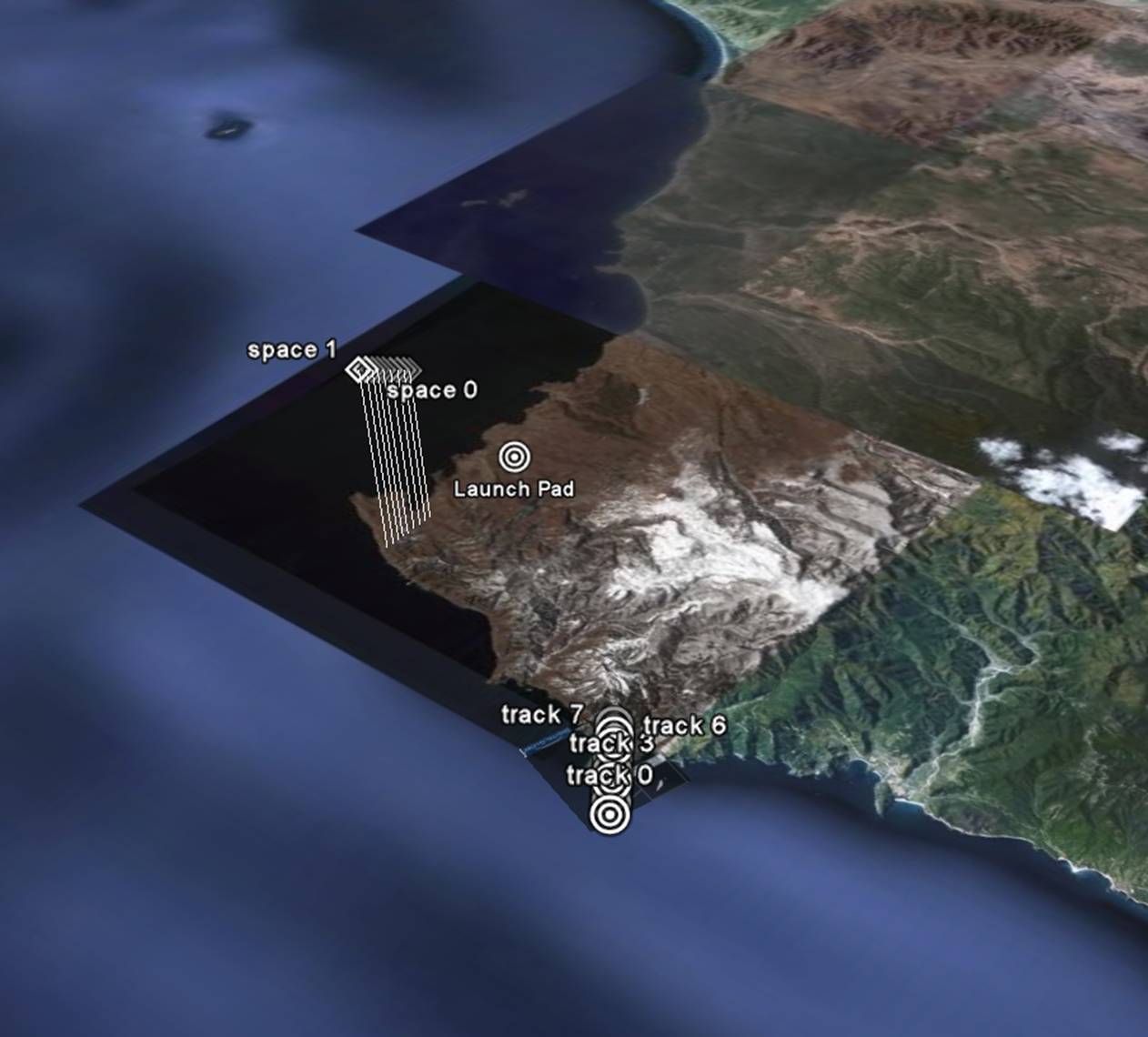
If you look at this image, the contrail, as projected against the ground is in the lower right corner and are represented as circular targets. ( You can find a GoogleEarth overlay of the contrail here.) The points in the “orbital plane”—the plane the rocket travels in, are shown as diamonds with little sticks connecting them to the ground (and are in the center left). These are the reconstructed points through which the rocket actually passed. If you were to connect the ground points with their corresponding trajectory point and continue on into space, they would all intersect at the location of the Worldview-1 satellites. And if you were to draw a line through the places where the space points’ sticks touch the Earth, it would pass through the launch pad, even if it doesn’t look like it would from this perspective.
Update: After discussions with David Wright, I went back and re-checked my calculations and, unfortunately, there was a problem with calculating the positions of the contrail from the alternate satellite positions. In particular, the position assuming the image was taken 30 seconds later than DigitalGlobe stated seems to indicate a considerably steeper raise to the missile so it is possible that could account for differences between this and David’s model. We will have to see if that timing is more consistent.
The trajectory is so sensitive to this timing because the image is taken at such a slanting angle. I doubt that DigitalGlobe or any other image provider would normally take such oblique angles. However, it is also clear that DigitalGlobe was trying to maximize its chances of seeing the launch. I suspect all the different commercial (and governmental?) satellites were also imaging the launch pad at large angles. I would guess that DigitalGlobe could see the launch site for at about 5 minutes before and 5 minutes after it passes directly over the launch site. That in itself improves the chances of seeing the launch to about 1%. If you include the other photoreccon satellites, this probability could “climb” to 5% or greater. So this was hardly the “1 in a million” chance that some satellite would photograph it that has been bandied about.

Geoff, i think i’m starting to understand what point you’re trying to make (GlobalSecurity obviously made more than one mistake in their article on this issue; direction and timing) – i just can’t coerce my mind into believing this!
That would be an absolutely exceptional unbelievable ultimatively improbable stroke of luck! (Even if this might have been planned from the start!)
BTW, new sat-photos of the launcher on the table: http://www.globalsecurity.org/wmd/world/dprk/no_dong-imagery-20090405.htm
please go here for some very good photos of the NK rocket. Looks rather advanced in design.
http://www.irandefence.net/showthread.php?t=47276&page=2
Looking forward to your comments
I’ve been wondering myself if the North Korean authorities didn’t get everything they wanted as a ballistic missile test. Crucial to my understanding of this: Does the Taepodong need a 3rd stage as a missile, as opposed to a rocket with a satellite payload? I realize this is absolutely basic stuff for you guys, but I haven’t been able to find anything that addresses this point.
Hi Geoff,
I am having trouble with something simple…
What exactly is the coordinate of the point where the digital globe image is looking at? Like, where is that peninsula exactly? I was unable to figure it out looking at Google Earth…nothing looks anything like right (at least to me)!
Thanks, John.
“So I am now favoring the hypothesis that North Korea was testing both the missile and an important part of the guidance program of an ICBM with this test.” There is obviously always a list of objectives in every test Geoff. For instance, another test could have been an analysis of Archimedes principle, to see how much higher the Pacific rose after it went into sub-aquatic orbit.
This of course raises the further question, where does the trajectory end given a range of possible/likely specific impulses for the second stage?
If it was a failed ICBM test, where was the actual destination? If it was a sucessful ICBM test then what does this say about NMD?
To John Field:
I’ve had more or less the same difficulties;
First of all, forget about the north-pointing arrow in the GlobalSecurity-image (and about the timing given there). Then try looking at the coast to the east of Cape Musudan (exactly where Geoff put the markers).
Another very important fact to know is the exact position of the satellite at the moment the picture was taken: latitude: 33°N, longitude: 126.6°E and altitude: 489.7km;
Because this absolutely incredible too-good-to-be-true one-million-dollar-snapshot was obviously captured at a rather steep squinting angle (while “peeking over the shoulder”), the shoreline appears somewhat distorted – but with these informations in mind can be matched quite well (try using the two beaches/valleys as landmarks).
Geoff, everyone:
How many stages did this thing have? If you look at the launch footage it sure looks like three.
But as someone pointed out earlier, there’s a puff of light-colored smoke from the first/second interstage at the moment of ignition, but nothing similar at the apparent second/third interstage. I’m not sure what to make of that. Does that imply that the apparent third stage is simply a large payload?
Any thoughts?
Does the DPRK have any capability to get telemetry over the horizon? without that, can they actually get good test data from later stages?
I am not sure what to make of this result. Geoff’s results give a trajectory angle of under 40 degrees, which is not what you would expect this early in flight for either a space launch or a ballistic missile. (Modeling shows that this picture must have been taken about a minute into flight, which also doesn’t seem to fit with the time stated for the photo.) You would expect an angle of 70-75 degrees for either a ballistic missile or space launch at this point in flight. If you put the TD-2 on a trajectory with this low an angle this early, it appears to fall to earth a few hundred km from the launch site.
So this angle does not seem to be consistent with either a ballistic missile or space launch. It may simply suggest a problem early in flight. Moreover, as I noted, this early in flight, the optimal trajectories for a ballistic missile and space launch are within a few degrees of one another, so I’m not sure you would be able to distinguish them this early in flight by the contrails.
So as I said, I’m not sure what to make of this results, but I don’t think I agree that it is evidence for a ballistic missile launch rather than a space launch.
-David
Josh:
No “smoke” on the upper stages does not necessarily mean that they were dummys or solid-boosters.
Compare this for example with liftoff-pics of the CZ-2 (this phenomenon can even be seen on the boosters) or the Dnepr-launcher. No additional “puff of smoke” can be seen on the upper stages of these missiles during ignition (BTW, this blow-off of waste-gas doesn’t happen everytime anyway – and note that the excess-gas always blows off near the top of the oxidiser tank). I think part of this phenomenon can be attributed to the proximity of the source of vibration (mostly the thrust chamber), another part to some sort of hydrodynamic shockwave in the propellant-tanks generated by the abrupt (explosive) opening of the valves.
But of course i can’t exclude the possibility that the North Koreans actually put a non-functional third-stage with a satellite-mock-up (i think they presented this to the world on 29. March: a missing payload-shroud could quite well explain the perceived “bulbous nose” – the satellite itself!) with the mass-properties of a (at that point) hypothetical payload; That would be a particularly insidious way of abusing an allegedly peaceful space-launcher-program, if you ask me.
One interesting thing about the photos of the launcher on the pad: you don’t see the open lattice of supports between the first and second stages that you usually see with a liquid-fueled second stage. The reason for the open lattice is that upper liquid stages are typically ignited before the previous stage burns out, so that ignition takes place under acceleration. In this case there may simply be a cover that is ejected before 2nd stage ignition, but it adds mass to the missile (granted, the lower stage, where it is less important). Is it just for looks?
http://www.digitalglobe.com/downloads/featured_images/musudan_ri_ov_april5_2009_dgl.jpg
gives an overview of the scene containing the contrail. It includes the launch pad, which has a large apparent smoke cloud to the north east. No contrail between there and the segment crossing the coast that I can see.
If the third stage was a solid rocket motor then there would be no fuel line emanations under any circumstances. This looks like a simple failed space shot. First and second stage did their job, third stage failed to fire/separate. Overall, I would rank it a technological coup and a political failure. The North Koreans were unable to preempt South Korea’s ~July launch of KSLV-1. But technologically they were able to test a four chamber extension of their Nodong engine on a relatively advanced new airframe; ~2.25m diameter, finless design and potentially a non vane steering mechanism; gimbaled or thrust variance. They managed to handle the second stage separation well, though it does not seem to be the same staging technique employed by the Iranians on the Safir SLV. The North Koreans did manage to have at least 1.4 g acceleration on liftoff which seems to imply that they may have been shooting for an optimal launch trajectory as opposed to the Iranian launch which was an energy inefficient launch due to engine thrust constraints.
1.4 Gs is more of an ICBM ascent trajectory than space launcher – max Q happens much harder and lower with that than for 1.25 Gs (typical SLV).
I was under the impression that optimal trajectory for a minimal energy launch requires something like 1.5g +-.1g at liftoff as the mass of the rocket goes to some arbitrarily large number. And that 1.25gees is towards the bare minimum(1.15gees) of what it takes to get to space. The Saturn IB prgram was able to decrease overall size of the carrier rocket by increasing liftoff accel from 1.25 gees to 1.34 gees http://ntrs.nasa.gov/archive/nasa/casi.ntrs.nasa.gov/19750063875_1975063875.pdf. I recall calculus of variations from school but I never touched upon Pontryagin’s and Bellman’s optimal control theory so I’ll leave the matter to someone else and bid you consider my statements as only uninformed opinion based on google-say.
Guilty until proven innocent?
If NK wanted to do an ICBM test, they would be definitely interested in a third stage separation and satellite on orbit.
If NK wanted to launch a satellite, and there is no reason why to think otherwise, they would be interested in a third stage separation and satellite on orbit as well.
On the other hand, that missile was very stable, without vibrations, and the start and first stage separation looked fairly nicely, so it wasn’t that large failure.
Re — Jun Okumura
Yes they would need a third stage, when they would like to hit a continental US. (electronic jamming, and MARV would be highly recommended as well) On the other hand they could hit US base on the Japanese isles fairly easily.
You’d normally want to maximize the payload for a given first stage engine, by increasing the propellant loading to the point of zero return, subject to other constraints. One would be the reliable burn time of the engine, another the maximum height of the rocket.
If the propellant load for the first stage is 75% of the total rocket weight and the sea-level specific impulse 230 seconds, then the burn times for the first stage are 123 and 144 seconds for initial thrust to weight of 1.4 and 1.2 respectively. It’s possible that the North Koreans can’t make the engine burn the extra time.
There could also be limits on the size of stages with respect to manufacturing or transportation to the launch site.
Thanks, Raghar. And they already have a couple of hundred Rodong for us.
In the full size image:
http://www.digitalglobe.com/downloads/featured_images/musudan_ri_ov_april5_2009_dgl.jpg, something like the shadow of the contrail can be seen in the upper left corner. If this is correct, this would allow for a triangulation of the launch vehicle’s trajectory, since the postion of the sun and the satellite are known.
Azr@el writes:
I was under the impression that optimal trajectory for a minimal energy launch requires something like 1.5g +-.1g at liftoff as the mass of the rocket goes to some arbitrarily large number.
If you don’t mind melting the nose of the rocket, sure. In reality, the acceleration off the pad at liftoff is a complex play between trajectory loft or depression (above/below gravity turn), Gs at liftoff, max-Q you can tolerate, etc.
The faster you go off the mark, the lower you are when you peak at max-Q (dynamic loading due to air loads, rho * v^2). Also, the longer you climb vertically before starting to gravity turn downrange helps reduce max-Q loads.
You can make extremely tough shrouds – among other things, a single warhead ICBM’s reentry vehicle has its reentry thermal protection system facing out into the launch max-Q flow, which helps a lot. But you also need to harden the upper stage, guidance electronics up there, etc. You don’t just get thermal load, you get vibrations across a wide acoustic spectrum.
Enough vibration and your satellite’s junk, and your guidance system will stop reading accurately. Enough heat, and you need to add ablative thermal protection to the shroud.