I’ve read Chinese Military Power and I don’t agree that it says China increased the size of its nuclear force by 1/3. When I do the math, I get basically 110-160 warheads — about the same size as last year or a little larger depending on how many DF-21s have a nuclear role.
Not that number of warheads is the really interesting information, but I digress.
Before that post, though, something that matters is where the DF-31 is being deployed. I have two hypotheses:
(1) China will deploy the DF-31 to units operating the DF-4, replacing the older missile on a one-to-one basis and keeping a similar force structure.
(2) China will deploy the DF-31 to new units in new places, presumably to cover targets in the US of A.
Of course, one might imagine a combination of (1) and (2), say new DF-31 replaces the DF-4 and new units to operate the DF-31A.
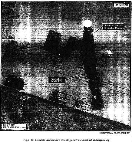
I say all of this to draw your attention to the image at the top of the post.
The image, captioned Fig 3. (S) Probable Launch Crew Training and TEL Checkout at Kangzhuang, is from a classified November 1996 report by NAIC, leaked to Bill Gertz, and published it in the appendix of his book, Betrayal.
NAIC (now NASIC) placed the DF-31 TEL at a place called Kangzhuang (I found it at 40°22’6.16 N, 115°35’51.59 E). As far as I can tell, no one else has linked the DF-31 to Kangzhuang in any other public reports.
I’ve been watching the area in GoogleEarth for a year or so. Today, I notice that GoogleEarth recently replaced some lousy pictures with a lot of very good ones. And there is a lot evidence that Kangzhuang houses a missile base including:
- Two valleys with buildings nestled in them that look very much look like other suspected missile deployment areas (Area 1 and Area 2).
- A surface-to-air missile site at 40°18’10.45“N, 115°38’19.90“E.
- A collection of strange looking buildings (Area 3) that seem military to me.
Anyway, I’ve saved them all in a GoogleEarth file for you.
Then again, I am a lousy overhead analyst. My readers, however, are pretty awesome. Anon nailed the Iranian Space Center at 35°23’20.46 N,53°44’11.05 E and Siwema used ground truth photos to place Egypt’s ETRR-2 at 30° 17’ 34.02 N, 31° 24’ 35.45 E.
Have at it.

Sorry Jeffrey (and Anon) but Anon did not nail the Iranian space center. Please see my article, in either the current Jane’s Intelligence Review (or the one that’s just about to come out, I’m not sure which) using images from 8 February 2008, for a discussion of where the launch center is and what the purpose of the facilities near the launch site are. (And their implications for Iran’s future missile/space activities might be.) The launch site is actually at 35.2344°N, 53.9208°E, and has undergone considerable construction since the Google Earth images (which are believed to be from 2004).
Oh! Sorry Geoff, didn’t mean to short-change you.
Will look forward to the article in JIR.
Hey Jeffrey: I did not mean to imply that you, or Anon, or anyone on this blog had done anything to “short change” me! I simply meant to imply that we had arrived at different conclusions and that I disagreed with Anon’s assignment of the position of the launch site. And, of course, to shamelessly plug my article!
I’ll refrain from attempting to interpret the putative DF-31 site because I’m not a photointerpreter/ imagery analyst either.(*)
But I agree that ACW has produced some very interesting pictures and interpretations. Have you considered gathering them into an album for posting on the New America site or elsewhere? I’ve done essentially that in some of the sourcebooks @ fas.org, and it’s pretty painless.
(*) Although in a long-gone year I spent many enjoyable hours sitting next to a light table in Building 213 while real PIs plied their trade.
I honestly can’t find anything that looks like a mobile missile operating base in those two valleys. The SAM site probably is for SA-10s but could be SA-2 Guidelines. However the missiles look a bit small for the old Guideline system.
The ‘military’ area in area 3 looks once again like a training ground for armored vehicle exercises. The desert paving is badly scarred. I note that there are a lot of very regularly emplaced small square areas nearby. It’s tempting to peg them as a tent city w/o the tents, meaning that this exercise are has a small garrison force and is visited by units being trained. But that may be reading too much into the picture.
Mobile missile bases built by the former USSR were very distinctive. There’s nothing like them in Area 1 or Area 2. Not to say that the Second Artillery has to ape the Strategic Rocket Forces; they don’t.
But the area sure looks like it’s made for ground pounders.
pz
I recognize my limitations as an imagery analyst.
Maybe we should get this guy to take a look.
Was about to suggest speaking to IMINT. Fascinating site and a really good example of open source intel.
At the very least he’ll be able to give you some SAM forensics.
There is a lot to disagree with in the Report.
One that I find most interesting is the implicit presumption that any conflict with Taiwan (whether or not it involves outside powers) can be contained to conventional war.
I do not agree. If outside powers get involved (name your scenario, from actual military action to ‘volunteers’ fighting on the side of ROC or whatever Taiwan will be called), it moves rapidly up the escalation ladder.
Here is a problem: do we even have an escalation ladder so to speak? Do we really know at what point China would say… enough?
Would it take an air strike on Shanghai and Hong kong? Beijing?
Landing of US military forces in Taiwan?
At what point do the ‘no first use’ policy (if it ever was valid to begin with) goes out the window?
In this context, an accurate count of warheads and their growth is an important issue.
I believe that Beijing will use (strategic) nuclear weapons on Taiwan before it allow Taiwan to secede.
The amazing thing is planners in the Pentagon apparently dismiss this possibility.
My question: Suppose Taipei, Kaohsiung, and Tainan were hit with nuclear weapons.
Will the USA be then at war with China?
Does that justify a nuclear strike by the USA on Chinese cities?
Think hard. How in the world do we keep this war “limited” once the shooting starts?
Would it be like World War I, where everyone (except Kitchener) expected a short war ?
Dear Sirs,
Reading the comments on what is what on the Google Earth Pictures I always wonder: How will we ever know? Are there real “ Gold Standards” in this interpretation-buisiness? I do not think that any army of the world will send You an E-Mail: “ Hey, You were right, that is our new secret airfighter”..On the other hand i highly respect the work done by You and others, I simply think one should be very cautious about the results of this kind of interpretation.
Yours Martin Dirksen
In response to Martin Dirksen’s perceptive comment, the only gold standard is ground truth — going there, looking around, and going into buildings.
In the absence of ground truth the analyst relies on an extensive catalog of data on (say) missiles that might be in the image, on knowledge of the operating patterns of the military in question (a friend identified a Soviet Strategic Rocket Forces base in an old SPOT image purely on the basis of the design of the obstacle course for personnel training. But he had seen dozens of SRF bases in much higher resolution images.
I suggested that the SAM site might have SA-10 or SA-2 missiles on the basis of measuring the lengths of the visible missiles. The resolution wasn’t good enough to see the fin structure cleanly. The Guideline is most probable, but it’s about 10m long and the ones in the pic were about 8.8 m long — however one would expect the images to measure shorter than the real birds as the nose of the missile won’t be well resolved because of the low resolution.
I’ve analyzed maybe half a dozen army bases with tank or armored vehicle exercise areas. They look like the one in Jeffrey’s picture. I was able to inspect a couple of such areas at Ft Riley, Kansas on the ground.
One problem with using Google Earth is that you only get a single picture at a single time. The real image analyst relies on having a series of 2, 3, many pictures of the same area taken over months or years. In particular, it’s nice to be able to see what’s inside a building before the roof goes on!
But analyst experience and training, tested against ground truth in exercises, is the best we can usually do. I’m lucky enough to have had a (short) military course in image interpretation and to have run a couple of research projects during the early days of SPOT.
—pz
You must have got it right, or very close, given that right now all I see in Google Earth at those marked areas are plain grey geometric shapes. The SAM site is still visible though.
Also I think the missile length fits the Guideline well, as if the missile is pointing slightly up in the air in launch readiness, that would also contribute to shorter apparent length in an overhead photo.
If there are 3 gray shapes, I places three semi-transparent overlays to identify the areas of interest.
You may want to turn them off to check out the buildings, which I admit are ambiguous.
The SAM site is an HQ-2 GUIDELINE site. The missiles won’t necessarily appear to be long enough when you measure them as they are on elevated launch rails, as Anon pointed out. There are seven other HQ-2 sites in the area as well. If you want to see all of the SAM sites in the area, download my database here:
http://bbs.keyhole.com/ubb/download.php?Number=406094
I’ll look at the facilities and see if I can come up with anything relevant.
Jeff,
what is your take on the two following photos?
Thanks
http://bp1.blogger.com/_3wZSwFvZzqM/R9NLdcNLc8I/AAAAAAAAAq4/9P5F1WdwsSU/s1600-h/df41_4.jpg
http://bp3.blogger.com/_3wZSwFvZzqM/R9NLK8NLc5I/AAAAAAAAAqg/cll-BE75VXw/s1600-h/df41_1.jpg
Jeff:
I’ve looked around a bit, and I believe I’ve located a bunch of DF-31 launch sites. What you’ve found doesn’t appear to fit the parameters for a missile base (everything I’ve found is quite far away, watch my blog for details). Look at the entrances to the buildings, for example. How on earth would a TEL get in and out of there?
Xinhui: could certainly be a TEL, but could also be a silo loader for the CSS-4.
I’ve got the DF-31 launch sites posted, let me know what you think. I have two or three other locations also under observation where I should be able to ID launch positions of other DF-31 brigades as well, but it’s taking some time to find anything useful.