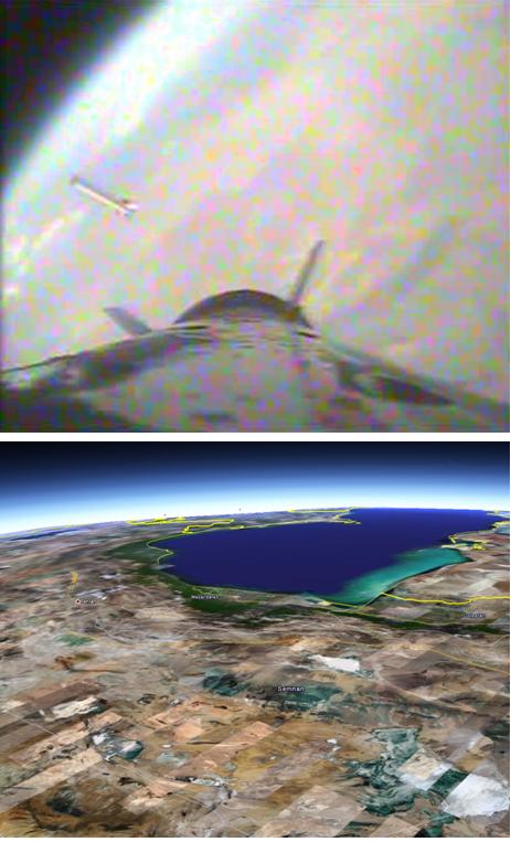
Well, I don’t know that its at its peak, perhaps the payload continued on for quite a ways. But what interested me about this picture (other than its really cool and it indicates that Iran is definitely studying its “staging” procedures using rocket-cams) is the possibility that this picture could be used to tell how high the Kavosh went. However, when I think about it, there doesn’t seem to be enough information to use the apparent curvature of the Earth to gauge the height.
One thing that I thought might work was to use GoogleEarth to tell how high the payload was when it took this picture by comparing landmarks. So if I say that the blue blob near the top of the image, which is also near the Earth’s limb, is the Caspian Sea with cloud cover away from the southern shore, then I estimate a height of about 200 km. But this is, of course, a very crude “calculation.” I would say it was consistent with my earlier calculations of how far a Zalzel missile would go, which shows how much faith I put in this method since I calculated about 140 km altitude.
Can any of you Wonk-readers see a better way of calculating this altitude? For instance, am I wrong about the scaling of the Earth’s curvature?

Doesn’t that second image look like a patchwork of overhead satellite shots taken at different times, instead of a real photograph?
I.e. this picture could be fake, and provide no real information about altitude.
In my excitement to get this up, I guess I didn’t make myself clear. The top image is the Iranian picture, and the bottom image is my GoogleEarth image, which is made up of lots of images taken at different times. I hope that clears things up.
Geoff,
try:
http://en.wikipedia.org/wiki/Horizon#Curvature_of_the_horizon
just eyeballing it — I’d say the curvature is greater in the top pic than in the google map. So I’d venture that the rocket prob. went higher than 200 km.
Yousaf—I’m not sure it is. There seems to be some sort of darkening near the left hand edge that causes the eye ball to think it is more curved than it is. Try putting a piece of paper over the left edge and comparing. But thanks for the website!
I think the curvature in the image would depend on the lens used on the rocket-cam. Perhaps someone much smarter can figure out if there is a wide-angle or fisheye lens based on dimensions of the visible rocket body, which I think would exaggerate curvature towards the edges of the frame.
If the dark bluesh mass that we see on the top of the image just before the curvature is the caspian see, I can tell that you have a directional error on your google re-construction.
I see the launch pad more in 8:30, 9 o’clock angle viewed from Tehran in the center of the clock rather than 3 to 4 o’clock as you put it.
Now from this position and given the azimut of launch seen on other images, I would say this launch has been done somewhere 100 to 200 Kms south-west of Tehran.
Source of the photo appears to be
http://www.isna.ir/ISNA/NewsView.aspx?ID=News-1245961
(scroll down)
And here is the web site of the Iranian R&D center which launched it:
http://www.ari.ac.ir/
Before checking your post, I applied the same technique in Google Earth; however, I did not notice the Caspian Sea (nice find).
Another method I was trying was to determine the center of the visible earth by drawing two lines perpendicular to earth surface at the two edges (one can draw a third line in the center to reduce the error). Then use Google Earth to produce a similarly sized image of the earth and finally, get the altitude from Google Earth. However, I didn’t finish it.
Any other ideas for calculating the altitude?
Geoff:
Any reason you think it is at the peak of its trajectory?
BTW, in an article in ISNA (it has the new image as well) it is mentioned that the whole process took 10 min. Also it mentions, the payload used air brakes to reduce speed then a small parachute and then a lager one for safe landing.
Here is another photo (what happened to the nose?):
http://64.130.220.65/Multimedia/pics/1387/9/Science/13.jpg
knotnic:
I don’t think an fisheye lens is used (FOV is not very large). The image seems reasonably flat and the separated rocket looks straight and not bended.
Also, the visible portion of the horizon seems to be almost completely covered by clouds, which has potential to complicate things a lot. The cover seems to thin towards the left, if the edge was near the left edge of the image, that could explain the aforementioned darkening at that spot. Second, the cloud cover top can easily be variable in it’s altitude, meaning the curvature we see in the image does not necessarily match that of the actual horizon. The image is not nearly sharp enough to make judgements about how the clouds may be arranged, which might give clues as to where the actual horizon lies.
Geoff,
as knotic mentions the lens is potentially a concern.
Also, I have not followed the discussions about the details of this rocket but it appears the photo was right after one stage was separated — do you expect the stage with the camera to also be possibly powered or is it for sure just the terminal payload? If powered, of course, it may go higher/more downrange.
To figure out the curvature of the earth you’d need to know the diameter of the 2nd stage and the distance from the camera. I mean, it could be a tiny little rocket with the camera on a long pole in front with a high-mag lens and that would make the earth thousands of miles away.
I agree with Amir that the image just doesn’t look to me like a fisheye lens. But just because it is flat, doesn’t make the image easy to interpret; and that’s without all the added complications of cloudy horizons. (Here’s a thought, suppose you just assumed that the clouds on the horizon were at 11 km, can you use the “step” in the horizon—forgetting for the moment that its blurry etc., to measure the distance? I think I will give that a try when I return from Geneva, where I’m at now, which explains why the posts are showing up so infrequently, by the way.)
Let me also reiterate what I said in the original post, I have no idea if this was taken at the peak of the trajectory. It just sounded like a good title and I would settle for knowing a minimum altitude the rocket went up to, i.e. the altitude of this picture. If its higher than 150 km, that would be quite interesting. By the way, be sure to check out “Ataune’s post”:!http://www.armscontrolwonk.com/2113/once-again-iran-launches-a-rocket-into-space! where he gives some information that was released by the Iranians about the launch.
The comments about fisheye lenses started me thinking about what we can learn from the over all appearance of the image. The thing that jumps out at me is that the payload section seems to be in very sharp focus, the more distance first stage body seems to be slightly out of focus, and the Earth’s surface is more or less completely out of focus. That, to me, means that the Iranians are most interested in observing the “staging” event and not at all interested in making observations of the Earth. (That makes complete sense if this was an engineering test.) Then, there is the rectangular box on the side of the payload which looks very similar to boxes on the Safir and Sejil (except those appear larger). I show the Kavosh box and the Safir and Sejil boxes below. To me, that proves that the Iranians were monitoring the staging of those missiles; which is hardly a surprise but does indicate that the Iranians are being much more systematic than, say, the Iraqis ever were in their missile development program. Now the question is: did Iran “beam” these images down to Earth while the rocket was still in flight, or did they recover the Kavosh’s payload with a film canister. Can anyone think of a way of determining that from the image?
According to the report on http://www.ari.ac.ir the photo was transmitted to a ground station while the rocket was still in flight – although we don’t know the timing of the transmission (was it live?).
At 1:18 we see some more of this rocket
http://nl.youtube.com/watch?v=glujfPnD4OE
The news report of the launch, published in the site of the R&D institute (http://www.ari.ac.ir/ – URL posted by one of your readers) is stating that the pictures were obtained “on-line”, by which I guess it meant “real time”.
Pedro,
the curvature of the earth can be directly read off of the photo assuming that there is no distortion and given some uncertainty for the clouds etc.
The only other thing needed to get the altitude is the radius of the earth.
From the photo + assumptions one can get the altitude.
I am wonky — but also lazy — so will leave this as an exercise for the student.
We have encountered the problem of doing measurements on images before. I wonder if using a CAD/CAM software package could help. We know the diameter of the Earth and approximately the dimensions of the rocket. Suppose you model the Earth in such software as a ball and the rocket stages as cylinders then super-impose the Iranian image, or use it as background. Now you can play with the location and orientation of the cylinders relative to the ball until you get a fit with the image. If the problem is not under-determined you got the solution and only need to read back the coordinates from the software.
Yossi,
one does not need to worry about the cylinders in obtaining the curvature of the horizon.
There is however inherent uncertainty in getting the curvature from a crap photo.
See the link by Yousaf above.
Also Ataune mentioned that the Iranians are saying the rocket went to between 50-200 km.
FSB: I think Pedro is correct – the magnification of the lens matters. As a thought experiment, if you took a photo of the Moon (from Earth) at an extremely high magnification, the apparent curvature could be quite low.
The missing factor that is needed is the angle subtended by the whole photo, so that the angle subtended by any particular feature with a known size (say, the Caspian Sea) can be calculated and from that the range.
In addition, at 6:00 on the last youtube video (posted by S.B.) one can see an image of the sounding rocket plus an image on the right that shows what is inside of it (I think).
It is being said that the rocket payload went to 200km
FSB thanks! My comment was half baked or worse.
If sufficient detail could be seen on the Earth then a CAD/CAM software could probably do the trick without using the horizon. It would need an Earth model with geographic details and model the rocket stages as cylinders. Unfortunately the image is very blurred and probably even enhancing it wouldn’t help much.
Can we compute the height from the curvature of the horizon? I think we still need to identify some geographic detail in the image (e.g. the Caspian Sea) and compare it with some kind of map (e.g. Google Earth). A practical method could be to superimpose the Iranian image on Google Earth and play with the controls until they fit together. However, the meager details and image obliquity will give a very rough result.
I know nothing about rockets and the related technology but the Farsi text does not mention the height was between 50KM and 200KM. It simply says that the payload was designed to conduct experiments at that altitude.
OK, take a deep breath…
Some geometry (I’ll describe it in a separate post if anyone really wants to reproduce it) shows that the apparent angular radius “Theta” of a sphere as you ascend from it is given by:
Tan (Theta) = R / SQRT, where R = radius of the sphere and H = height.
Assuming the earth to be a sphere of radius 6370 km, this means that from a height of 200 km the apparent angular radius of the Earth is 75.83 deg (or alternatively its angular diameter is 151.66 deg).
So, if we know the angular size of the Earth in the picture, we know the height.
To get the angular size of the Earth, we need some sense of scale.This is provided by the provided by the back end of the rocket in the photo.
Assume that the “curvey bit” between the fins is a cylindrical casing, and that the camera angle is low enough that what we’re seeing is the arc of a circle (rather than the projected ellipse). Print the photo – on some large paper – and use a pair of compasses and ruler to find the centre of the circle. Measure te radius (or diameter if you prefer) in mm.
Do the same with the visible of the Earth i.e. find its centre, and then measure its radius. The ratio of the radii is equal to the ratio of the tangents of the projected angular sizes. I get a ratio of about 12.68, which means that the tangent of the Earth’s angular radius is 12.68 times bigger than the tangent of the angular radius of the back-end of the rocket.
Now we have to make some assumptions. Assume that the radius of the “curvey bit” between the fins is really 0.5m, and that it is 1.5m from the camera. The tangent of the angular radius is therefore 0.5/1.5 = 0.3333. Then multiply by factor 12.68 to get the tangent of the Earth’s angular radius (= 4.226). Thus the Earth’s angular radius is 76.7 degrees.
Now go back to the height equation, to find that Earth will appear to have an agular radius of 76.7 degrees only if you are 175 km above the surface.
Based on this method, we only need to know the rocket’s diameter at the “curvey bit”, and the distance of the “curvey bit” from the camera, and their ratio wil give the height.
In the next post I’ll give some examples.
Hopefully my previous post will appear before too long, otherwise this post is going to be even more incomprehensible that my usual mutterings!
Based on my previous post, if you divide the (assumed) distance from the camera to the “curvey bit” by the (assumed) radius of the casing at the visible “curvey bit” hen you’ll have a ratio.
For example, if you think the casing is 0.6m in radius at that point, and its distance from the camera is 1.44m, then you’ll have a ratio of 1.44 / 0.6 = 2.4. The height of the rocket can then be estimated from the tabulated results of the calculation in my previous post:
Ratio Height (km)
2.0 80
2.2 94
2.4 112
2.6 132
2.8 152
3.0 176
3.2 200
3.4 224
3.6 250
3.8 280
4.0 308
4.2 338
etc
So, the calculation of the height of the rocket is very sensitive to assumptions of the casing radius (probably know from other photographs in the open literature) and the distance from the camera to the relvant part of the casing.
An alternative method for “measuring” the distance from the camera is to extend the straight lines of the casing’s edges to their perspective vanishing point. If you measure the angle (I make it about 143 deg) you can use a perpective transform to calculate the viewing angle (I make it close to 10 deg). From there, if you know, or assume, how far the camera juts out from the casing then you can easily work out the distance to the “curvey bit”.
The whole method also works for the fins, if only you know their physical separation and how far they are from the camera.
Lastly I’d like to address the point of camera distortions and fisheye lenses: A fisheye lens basically compresses the angular diameter of an image, with the greatest distortion at the edges. Therefore if the picture has been affected by a lens distortion, the angular diameter of the Earth is probably more greatly affected than the angular diameter of the casing (which is more towards the centre of the frame). In this case, the “real” Earth (if you could sit on the casing and observe it without lenses) would be angularly larger than the picture suggests, and a larger angular size for the Earth implies greater proximity to the ground. Thus, if there is a lens distortion, it would mean that any calculations are an upper limit on the rocket’s altitude.
I agree with the majority opinion that the probably isn’t much lens distortion in the photo, therefore considering the general inaccuracy of whatever results we get it’s probably not worth trying to do any lens correction.
The methods I describe above suggest (not surprisingly) a range of altitudes around the 140 – 200 km that Geoff got just by looking in Google Earth. But if anyone is able to give reasonable estimates for the casing diameter and camera-casing distance then it might be possible to constrain the altitude estimate a bit more.
I feel like a complete idiot! – assuming that the little rectangular box at the side of the casing (in the top photo of Geoff’s 02 Dec 12:06pm post) is the camera housing, then the ratios needed for calculating the altitude are easily determined.
I’m on a borrowed PC at the moment, but if no-one’s done the calcs by the time I get back my own PC then I’ll do the numbers.
I guess that by the time this post appears there’ll already be dozens of posts pointing out what I’ve just completely missed. Well, sorry folks – I must have had a bit of a senior moment! 🙂
It seems that the square root in my earlier post was misinterpreted by the website as some kind of command. Anyway, the correct equation is:
Tan (Theta) = R / [square root(RxR + 2xRxH)]
Reverting now to the height achieved, I’ve printed and measured Geoff’s photos and also the one of the nose cone on the ground (in the link posted by Amir), and I come to the following conclusions:
1) The “curvey bit” in my original posts is the red / brown struture just behind the fins in the ISNA photo posted by Geoff. Meanwhile the camera is assumed to be at the rear of the structure circled in red by Geoff.
2) The radius of the “curvey bit” (maybe someone can tell me what it is properly called, please!?) in my print out is 41mm, and its leading edge (i.e. the bit I’d expect to see in the photo taken at altitude) is 66mm from the assumed position of the camera.
3) This gives a ratio of 1.610, which translates to an altitude of 203 km when the photo was taken.
4) If I assume a 1mm error in my measurement of the radius then I get an altitude error of about +/- 9 km depending on the direction of the error.
5) Similarly, if I assume a 1mm error in my measurement of the distance, or if we assume the camera is set a little way back from its window, then I get a difference in altitude of about +/- 7 km.
There is no shortage of other errors in my analysis, especially in the measurement of the Earth’s and rocket’s diameters, but overall I’d suggest that the rocket was at 203 km when the photo was taken (+/- at least 30 km for all my errors).
A result of 203 km is consistent with the statement from the Iranians that the rocket was part of atmospheric tests between 50 and 200 km, and also consistent with Geoff’s initial estimate of 200 km.
What do we conclude from all this? My own thoughts are:
1) The Iranians were being perfectly truthful when they said it was designed for / did tests between 50 – 200 km.
2) The first stage is still pretty close in the photo, so presumably the first stage did all the work up to that point. (Maybe the rocket wonks will infer something about the first stage’s capabilities based on a – I think demonstrated – altitude of 200 km).
3) The lack of visible exhaust from the second stage suggests to me that it is unpowered. Also, I suspect that the photo represents the second stage’s apogee (if not, why not release a photo from further up?), which would also suggest that the second stage is unpowered. However, I’m out of my field here and could so easily be wrong.
4) The “rectangular box” circled in red in Geoff’s ISNA photo is almost certainly the camera housing.
Going back to Geoff’s question about whether the photo was transmitted, or instead carried to the ground, I can’t see any advantage in transmitting it. The rocket is anyway designed to come back to the ground, so why go through the hassle of real time transmissions? Additionally, if the data are trasnmitted they are either “in clear”, in which case anyone can listen in, or else they must be encrypted, which adds proceesor load and probably slows the data rate (and in any case listeners may be able to infer interesting things, such as start-up of a new engine, from an increase in the data rate or change in data entropy).
For a test of an ICBM, where it lands in the sea, or maybe is destroyed, I guess encrypted telemetry and photos are unavoidable. But I would suggest that if the rocket’s coming down in a controlled way anyway, it’s far easier and simpler to just extract the memory stick once it’s on the ground again!
Even if you do happen to lose the occasional rocket and its data, I can’t imagine it would be such a disaster because these things look kinda cheap / “disposable” – I mean, they don’t give me the impression that they’re as expensive or complex as, say, a Trident. If you lose one then, so what? Send up another!
All in all, I vote for the photo being carried to the ground.
Hairs, we have been in the middle of a discussion and you asked for a link. I posted two replies but they didn’t appear. If you want you can select the link under my nickname, then select the one offered. You will get into a kind of blog where comments are instantly published. I copied our discussion there for your convenience and added the link you requested and instructions how to identify the mystery container.
In the Farsi Article it says that the data such as temp, pressure and other atmospheric data were transmitted back in real time. It also says that there were no cameras onboard to take pictures of Earth. The only cameras onboard were to capture the separation and parachute deployment phase of flight. It says the payload is very simple and just intended to make measurements for future flights. It also says future payloads will carry cameras designed to take pictures of earth.