Click on the image for a larger version
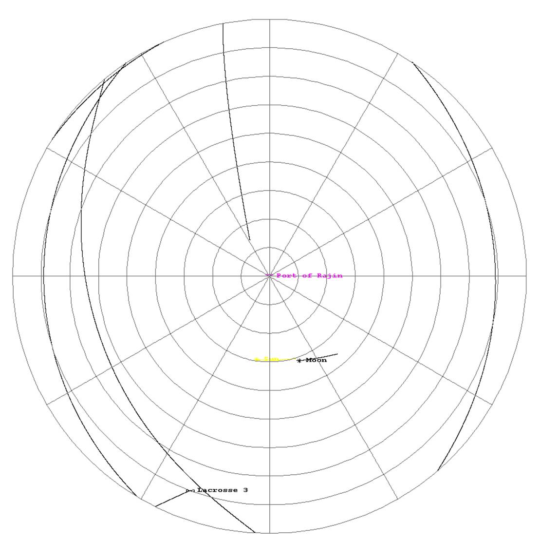
In a typical one hour period, five US low earth orbit satellites pass over the Port of Rajin
Yesterday, I pointed out that the only way for the West to tell the difference between a cargo container full of uranium gas centrifuges and a container full of pig iron as it was being loaded might be increased security associated with the centrifuges. That, of course, assumes two things: 1) that the West can see the loading and 2) North Korea decides that it wants to include the security. After all, Syria apparently decided to do without anti-aircraft batteries and other security measures for its Box on the Euphrates in order to avoid signaling the US that it should pay special attention to that building. We all know how well that worked: it seems to have fooled the US but Israel, with its spies in Syria (the ones who smuggled out the photos of the construction, presumably from a central office in Damascus) managed to obtain the evidence they needed. Unfortunately, it is doubtful that Israel has spies in North Korea (I guess I could be wrong about that) so we are probably left with using technical means to watch the loading and unloading of ships.
One possibility is to use satellites and another is using UAVs. Let’s consider using satellites, mainly because this post is already getting too long. As the image above shows, the US has a great many low earth orbit (LEO) satellites. The orbital elements for these satellites comes from an amateur satellite observers website and could very well include satellites that have ceased to function. (That’s my fault and not the amateur observers. On the hand, North Korea might not know any better than me which satellites were functioning and which are not.) They do not include the Navy’s NOSS satellites which are used to track ship locations. Those satellites were going to be considered tomorrow when I thought we would look at tracking ships on the high seas as a way of determining if their cargo might be suspicious. It turns out, however, that there might be other, more convenient, ways of doing that (See Allen Thomson’s posting and the responses to that) so I’m going to skip that post.
If you simply require that a satellite be above the local horizon to spy on North Korea, then these satellites supply considerable coverage. ( Click here to see a graph of the satellite elevations over the Port of Rajin during a three day period.) Of course, viewing a scene at a grazing angle—unless you are something like an electronics intelligence satellite which could conceivably pick up the radio chatter between security elements—can prove difficult to interpret. Of course, it’s still possible to see things at angles very close to grazing, just things like buildings and trees get in the way. That and the fact that you are looking at very large distances, perhaps as much 3000 km, so the resolution will be very poor.
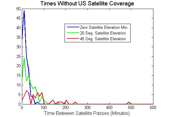
With that in mind, I plotted the time between satellite passes where a pass is counted as starting when it appears above a certain elevation and ends when it dips below that elevation. ( This plot is shown here for three threshold elevations: 0 degrees, 20 degrees, and 45 degrees.) North Korea, too, could generate just such a plot and know that critical signatures, such as deploying security forces, would have to be timed to fit in between passes. If satellites can detect signatures at grazing angles, then typical separations between US LEO satellite passes is about 10 minutes. That seems very short, though I have no experience deploying security forces. Its worth pointing out that if the satellite is a photoreconnaissance satellite that normally has a resolution of 10 cm at 200 km, it has a resolution of 1.5 m at 3000 km. There might also be a big decrease in sensitivity of electronics intelligence gathering depending on how they normally function.
Going to a 20 degree threshold substantially reduces the slant range but also substantially increases the time between effective passes. Thus, there is an average gap of 34 minutes between satellite passes in that configuration. Much more can happen in 34 minutes than in 10 minutes: more troops could be better deployed etc.
There are still more practical questions to be answered about achieving “reasonable grounds” for interdicting WMD. Clearly human intelligence would be the best. But that has important problems too, such as protecting the life of the informant if you ever have to prove you had “reasonable grounds.” It seems possible to use technical means to increase your confidence by seeing an unusual amount of security. But the most likely clue might simply be the destination: is it another “rogue” nation? Of course, if all the “law abiding” nations won’t trade with a rogue, perhaps their only trade partners are other rogues.

Of course, if all the “law abiding” nations won’t trade with a rogue
So why do so many countries trade with the US and Israel?
This may be a noobish question, but how about the weather factor? I suppose that thick cloud layer cuts off satellite visibility or at least decreases it’s resolution.
Therefore, it would be only a matter of timing the entry to the harbor and unloading. The more sophisticated way would be to arrange rendez-vous with smaller ships under clouds and transferring the cargo while on sea.
> This may be a noobish question, but how about the weather factor? I suppose that thick cloud layer cuts off satellite visibility or at least decreases it’s resolution.
Four of the US’ LEO imaging satellites are “LACROSSE” synthetic aperture radar platforms and are unaffected by weather (well, mostly). A slight caveat is that one of them is very old and may not be in the best operating condition.
Speak of the devil—-
US Military Tracking North Korea Ship Suspected of Proliferating Missiles, Nukes
According to the article, the ship has been tracked by the US military since it left port, which suggests that there is a method for choosing suspect ships based on port activity.
The method might simply be that the ship was described in the article as a “repeat offender”.
What U centrifuges? NK has Pt based nuclear program.
raghar, check the newspapers. NK is promising to develop uranium bombs.
At present, NK has not made any statements (that I’ve seen) about U weapons. Instead, the NK Foreign Ministry has released two statements that include references to enrichment in the context of LEU fuel, a predictable rhetorical development that has been surprisingly long in coming.
Don’t feel bad, though. This issue has been misreported by a wide range of sources. Without consulting the original statements, one just wouldn’t know what they contained.
Once again I’ve been caught not staying up to date by failing to read the Totalwonkerr! When will I learn!
Perhaps I should simply have said that when North Korea handed over its nuclear declaration, there was what some people suspect was HEU contamination. (“Coated” was the way I heard it described.) But there was controversy even about that. (See James Acton’s analysis of particle size/measurability. The latest is here.) All of which, however, gives us ample grounds for considering the hypothetical case of North Korea either importing or exporting centrifuges.
Once you have developed and miniturized implosion devices using plutonium, what is the point of going the uranium enrichment route for weapons production. As far as I can see, which might not be very far***, the only advantage of enriched uranium is that gun-type bombs can be built that will work without a live test so that you have plausible deniability of a nuclear weapons program. North Korea does not want or need plasible deniability, in fact it has shouted its intentions from the rooftops. This leads me to believe that the whole “uraniam enrichment program” is designed to wind up the US government and not for weapons use. Since the current reactor design that North Korea uses relies on natural uranium fuel and North Korea (according to FAS) has 4 million tons of high-grade uranium ore, I have my doubts about the need for an enrichment program for fuel production.
One way to stop the North Koreans proliferating a technology that by all accounts they don’t currently have,need or really want, is to stop them developing that technology in the first place. So why can’ t the US accept North Korea’s “right to exist”, remove all the sanctions, honour all previous agreements, open up trade and tell any neo-con stay-behinds in the Treasury who want to take further pops at NK using Banco Delta Asia to STFU. In return the US should say that it wants the right to carry out inspections anywhere in North Korea on a rationed basis, say, one every five years. If North Korea misbehaves in future, there is nothing to stop the US re-imposing whatever sanctions it wants to at any time. The US should just accept that the rest of the world might not be that interested in US attempts to get Kim Jung-il to kiss the US President’s arse!
The US has isolated (well sort of) North Korea for the last fifty-odd years and got no where. What makes anybody think that another fifty years of the same failed policy will get the US what it wants?
*** – wiki says that depleted uranium is used as part of the staging for an enhanced device but whether this means that it must be depleted uranium or it could also be natural uranium is one among many things I am not clear on although the North Koreans most likely are.