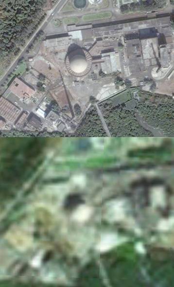
India’s CIRUS reactor in Google Earth (top) and Bhuvan (bottom)
I love Google Earth and don’t know how I could have ever done my job before it was invented. (The love is apparently not mutual since Google censored my work on China’s ASAT, at least in China.) However, not everyone loves Google Earth (GE). Perhaps you remember India strongly objecting to GE when it first came out. Of course, India has always objected to people photographing its bridges and military instillations and perhaps it has a point considering how the Mumbai terrorists apparently used GE to familiarize themselves with their targets. These are some of the issues we who use open source information have to face. that is why it is so surprising that India has, apparently, introduced its own knock-off of Google Earth with the introduction of Bhuvan, Sanskrit for Earth. It seems like India has decided that if you cannot ban GE, you should emulate it, but at a much reduced resolution. And as far as I can tell, no coordinates. (In the interest of full disclosure, I have to say that I am just getting familiar with Bhuvan and some of its features might not have revealed themselves to me.)
Both the low resolution and the lack of geographic coordinates would make Bhuvan much less of a security threat, but of course do nothing to get rid of GE. As the above two images show, GE has little to worry about as far as competitors go; the resolution of Bhuvan is reported to be 5 meters which severely limits it usefulness for, at least the kind of work I do. (Interestingly, the little blurb I saw that stated the resolution was 5 meters also bragged about how you could zoom down to 10 meters while GE was limited to 200—is that true?—it didn’t say, however, that 5 meter resolution looks awful at 10 meters height.) Bhuvan does look like it will eventually have some interesting features such as reporting the type of soil in different locations. But if this proves useful, GE will undoubtedly incorporate such information too.

lots of people would be delighted to see soil-type and other geologic data in GE. think of people running agribusinesses, just for one example. so there’s no doubt it’d be useful; i’m wondering a little about its feasibility, though —- it seems such an obvious thing to include, i suspect there’d have to be a good reason for it to not be there already.
I don’t know too much about soil analysis, but it seems like this type of data would be much more difficult to obtain (and have a higher marginal cost) than satellite imagery. It’s also highly commercially valuable (to the Agri sector), so you’d think that the people that generate the data would have a very strong interest in preventing others from redistributing their data for free.
On the other hand, I could have said the exact same thing about 2.5m satellite imagery ten years ago, and look where we are now.
Nomen,
Here are non-GE sources of the data your looking for:
http://eros.usgs.gov/
http://edac.unm.edu/wordpress/
http://www.nesdis.noaa.gov/
http://earthobservatory.nasa.gov/
Having something is better than having nothing… @INDIA
the last bit (highest zoom) images in google earth are from low flying aircraft and not satalite images. complaining about lack of resolution in big cities for google earth and bhuvan is like comparing apples to oranges. i would suggest comparing rural/farm/hilly areas of GE with bhuvan. i am sure THAT comparison will be fair
It appears I need to explain a little bit more. This post is about how India is responding to the security implications of Google Earth, though perhaps that doesn’t come through clearly. It is my understanding that it is, or certainly was, illegal for aircraft, or even tourists, to photograph things like nuclear reactors. So if India has changed that law, that is the real story.
Sunil,
The images of such Chinese locations as the Jiuquan launch facility, Malan nuclear testing site and others seems to undercut your assertion as it is quite certain the PRC government did not allow low-altitude photorecon flights to be performed for the benefit of foreigners over these sites. Also, the source of the imagery is alwas given at the bottom of the screen in GE, and I have yet to see anything other than a sattellite source.