Is the Box-on-the-Euphrates in a remote place?
Details like that might seem insignificant, but they are not. Often, it seems to me, intelligence judgments are supported by informal bits of “color” or what you might call the gouge — circumstantial details that aren’t part of any official briefing, but appear in loose talk to bolster a judgment. Recall the “viewing stand” that North Korea never built, but nonetheless contributed to a false alarm about North Korean nuclear testing in Spring 2005.
One detail in the Box-on-the-Euphrates story that seems to lend credence to the “nuclear reactor” hypothesis is that the site is remote, and therefore suspicious. Here is how Martha Raddatz at ABC put it:
The official said the suspected nuclear facility was approximately 100 miles from the Iraqi border, deep in the desert along the Euphrates River. It was a place, the official said, “where no one would ever go unless you had a reason to go there.”
But the claim the the location is remote is, itself, an exaggeration.
The Box-on-the-Eurphrates is a little more than a mile from a well-known tourist site, the ruins of Halabiya (or Halabiyya or Halabiyah), which the Syrian Ministry of Tourism website describes as “forward-defence lines against Persian invasions.”
Lots of people, actually, do go there — or at least pretty damn close.
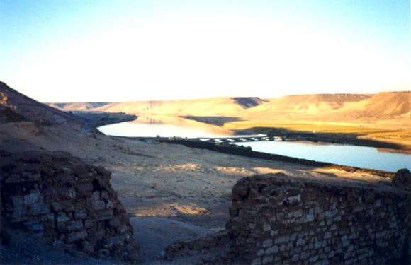
And, as you can see from the photograph at the top of this post, they take pictures. This is a picture, looking up the Euphrates at the canyon in which nestled the box-on-the-Euphrates. Although the reactor would be out of view from this spot, the pumping station would be quite visible as well as quite a bit of the comings and goings at the site.
There are lots of pictures like this, actually. Sylvie Bletry, an archeologist, has some lovely shots of the site, as do other vacationers. You can even organize a rafting expedition down the Euphrates.
Hmmm, that seems like a good use of my grant money.
This picture was taken from a bridge less than a mile from the reactor. Had the photographer turned 180 degrees, she would have been less than a mile from the pumping station, which would have been in plain view.
All of this is to say that when someone tells you the site is remote, he has already made up his mind about the purpose and is attempting to persuade. The ruins are quite obvious in the imagery and any analyst looking at the photos must have wondered about that strange site. (I did and looked around one afternoon until a couple of colleagues beat me to it, e-mailing me the name.)
It seems to me one can say many things in favor of the reactor hypothesis, but location is not one of them.

I think this is a fair observation, but one can question what it means for something to be remote.
Dimona, for example, is in a remote part of Israel, but it is visible from a main highway on the way to the Dead Sea.
I think that any site would not be “remote” enough for a Mossad or CIA agent.
Also, supposing that this site was a nascent nuclear reactor, it would be useful to have it near a source of water. In a desert country, there aren’t too many options for this—the site chosen was likely a “best possible option,” despite a nearby tourist site.
The site is remote, and in godforsaken wilderness.
That does not mean that people don’t go down the river nor that tourists travel the area for the archaological and historical value.
Dimona is (was) remote and in a godforsaken wilderness, but you can see it (better not approach it, tho. The Israelis shot down a civilian airliner in 1973 because they feared a terrorist was going to ram into Tel-Aviv or the reactor. 9-11 was but the latest not the first terror attack by airliner.
It is at minimum a military facility. The water intakes cannot be hidden (if the big river is required for a water source.)
The Syrians would know that it cannot be invisible from above, but would at least want it unintrusive from the ground and far as possible from Israel. They would want it near bridges and near at least small settlements.
If it was a reactor, I suspect that the Syrians would have announced it eventually. As long as they produce a few watts of power or a medical isotope or two, the IAEA would swoop in and slobber them with big wet kisses, quivering with joy that another triumphant success of the Maximum Proliferation clause, Article IV of the misnamed NPT has worked its magic.
Slap in some cameras and some stick-on labels, and promise to never-ever toss out the IAEA – cross-your-heart-and-hope-to-die, and be welcomed as a good nuclear neighbor.
> visible from a main highway
There seem to be both a highway and (I think) a railroad running along the east bank of the Euphrates past the mouth of the wadi. I’ve tried to use the Google Earth tip/tilt tool to get an idea of whether the Big Box was visible from them, but that’s a tad beyond what GE can do. Perhaps somebody with better GIS tools could check this out.
BTW, Digital Globe got shots of the site on 5,10,15,18 and 28 August 2007. Apparently somebody who had been tipped off to the issue put in an order for special coverage — you can see that it wasn’t routine by turning on the GE DigitalGlobe layer for 2007.
If somebody has the skills, interest and money to see if any interesting information can be teased out of the images, their DigitalGlobe catalog numbers are 10100100070A0D01, 10100100070A0E01, 10100100070E7C01, 1010010007125B01, 101001000714C801, and
10100100071CCB01
> I’ve tried to use the Google Earth tip/tilt tool to get an idea of whether the Big Box was visible from them
Ok, senior moment there: the digital elevation display in GE lets you get an idea of visibility fairly directly without tipping and tilting.
The Big Box is, as noted, in a wadi, a fairly deep one. Start the GE ruler, anchor one end on the Box, and draw lines to the highway that intersect the walls of the wadi. Doing so, it appears as if BB was shielded from the view of passerbys primarily by the bluff at 35.708 N, 39.830 E. Secondarily by the ones at 35.707, 39.832 and at 35.708, 39.827.
My point is that “remote” is a kind of word that conveys a judgment, rather than falsifiable information.
If someone describes a site is remote, he really means it is suspicious. We have no way of knowing what “remote” means absent the purpose of the facility.
If the source had said the site “was 10 miles from the nearest populated place, not visible from the road and surrounded by barbed wire and anti-aircraft guns,” we could evaluate the truth of the statements as well as their implications for the purpose of the site.
I agree that neither a nuclear reactor nor a military facility need be sited in a remote place — but I am not the one who darkly intoned the site was “where no one would ever go unless you had a reason to go there” as evidence of its purpose.
That was someone peddling this story, using a false (and potentially irrelevant) statement. One reason to go “there” or at least within one mile is tourism, whether you like Roman ruins or rafting.
There is no way around that fact.
Very good, I hadn’t noticed how close the Box is to the archaeological site of Halabiyya.
The difference between Dimona and the Box-on-the-Euphrates is that Dimona is a big complex, with protection, and the Box-on-the-Euphrates is just that, a box and nothing else apart from the famous pumping station. Not even a fence. Any Israeli spy with a foreign passport and a tourist visa could rent a car and go and look. I should think they did.
Contrary to what is supposed by most US conspiratorial theorists, the Syrians are not more clever than the Israelis. If they build a nuclear facility, they will protect it.
They didn’t need specially flown Digital Globe imagery. Israel has access to military satellites. DG imagery is for the public. Allen Thomson may be right that someone was tipped off, but who? Nothing has come out in public using multiple August images.
I would think that either the surface spying operation failed, for some unexplained reason, and they bombed on the off-chance, or that they knew perfectly well that it was not a nuclear site and bombed in order to provoke. Given that in this febrile atmosphere there are many outright provocative lies coming out of Washington at the moment in relation to Iran (Bush: they have announced their nuclear weapon ambitions), such provocation is scarcely beyond possibility.
By the way, congratulations on inventing (if it was you) the expression ‘Box-on-the-Euphrates’. Very appropriate. I like it.
“Box-on-the-Euphrates” is mine, yes.
Thanks for the compliment.
There’s been a lot of interesting points about things missing or existing and thus supporting (or not) various theories.
Like – how can there be nuke samples if the place was incomplete? Or, where’s the concrete batch plant? I like the VAB for SCUDs idea. But one thing missing (I think) that is common to ALL military facilities pretty much worldwide – where’s the perimeter fence? Even in the lower resolution images I can’t discern a continuous fence line and a parallel patrol track. Anybody…??????
Given the proximity of the Box to an archaeological site, perhaps the Syrians had unearthed the Lost Ark of the Covenant and the Israelis weren’t taking any chances… 🙂
As I pointed out a week ago (http://warincontext.org/2007/10/29/editorial-the-box-on-the-euphrates/), the fact that the Box on the Euphrates is not in a remote location is evident simply from studying Google Earth images. It’s very easy to zero in on the site’s location because the Euphrates river valley comprises two broad ribbons of rich agricultural land in the middle of which an arid interlude — no more than a few miles long — divides the river valley. This is the spot that, from a narrow-angle view, looks like the middle of nowhere.
(See image on my posting – link above.)
Syria is not the American mid-West — in other words, agriculture is not highly mechanized and thus requires plenty of labor. Close to the “isolated” location that the media has only depicted in close aerial shots, there are lots of towns and villages. A surfaced road and a railway track run either side of the “nuclear” site. By no definition of the expression, can this be called “the middle of nowhere” — unless, that is, it’s an expression being used by those parochial observers who regard Syria itself as the middle of nowhere.
And BTW, I’m happy to have made use of Jeffrey’s “Box on the Euphrates” — pithier than the IAEA’s “tall building shaped like a square.”
ACW Krewe,
I don’t have the cash to lay out for the DG photos Allen Thomson mentions above. I have to work with freebies. Nonetheless there is information to be obtained by looking at freebies. I have now determined that the “Lego Factory” on the Euphrates was constructed between May 26 of 2001 and September 8 of 2002 (a 67-week interval). My findings are presented below.
In the first pair of satellite photos I compare a 15-meter resolution Digital Globe image photographed in January 1999 with a 1-meter resolution GeoEye image photographed in September of 2003 when everyone agrees that the Lego Factory was present. Careful comparison of these two images shows that in all of the river diverticula other that the target diverticulum the surface topology features present in the old 15-m image are also present in the newer 1-m image. In the target diverticulum in the newer image it is clear that much of the surface features present in the older image are no longer present in the newer image. Obviously the much of the land on this diverticulum was cleared prior to construction of the mystery building.
Although there is an object due west of the Lego Factory about 1/3 of the way to the river in the newer photo, this object is not another building, but rather an artefact. This can be seen by blowing up the newer photo and comparing it to the recent New York Times photo of the same scale (but better quality-the New York Times spent some cash). Both of these photos were produced by GeoEye on 1/16/03 (see below). The object which appears to be a possible manmade structure in the freebie photo is revealed to be an especially reflective surface feature in the New York Times photo.
Finally, I obtained another satellite photo of the region taken on May 26, 2001 by the USGS Landsat 7 satellite. It is apparent from looking at this photo (see below) that the target diverticulum was still in its wild state at this time, and that the 40-zillion terawatt doomsday plutonium factory did not yet exist.
Analysis: Since the mystery building was less than 6-1/2 tears old when Israel bombed it the idea that it was merely a rusty old empty warehouse doesn’t wash. Clearly Syria got caught with its fingers in some kind of cookie jar. The question which remains is what kind of cookies it was trying to filch.
Correction to previous post:
GeoEye photos obtained by the New York Times and myself were photographed on 9/16/03 and not on 1/16/03 as stated above. Apologies for the typo.
The German transliteration halabiye seems to generate the most search hits. A Flickr search
(http://www.flickr.com/search/?q=halabiye) for instance
shows some interesting hi-res tourist pictures people have taken in the area. There’s a nice one with a very similar angle to the image you posted, and good pixel resolution (http://www.flickr.com/photo_zoom.gne?id=476349306&size=o). There are also a few under the “halabiyya” and “halabiya” spellings. I haven’t oriented myself so I’m not quite sure what I’m looking for in the images.
Google images doesn’t turn up any high-resolution pictures under any of the spellings that I could find.
This is a low resolution image but a Japanese traveler with the handle “boukein110” took this September 2006 shot:
http://m.4travel.jp/img/tcs/t/pict/lrg/11/83/22/lrg_11832236.jpg
while standing on the bank what seems to be directly opposite the wadi in which the Box on the Euphrates is located.
Dear Dr. Jeffery Lewis,
Though I understand the intention of your post, to clarify the geographical position of this site in relation to people, once this fact has been established, the discussion should turn to the more pressing issue of whether or not this site/location is viable as a nuclear facility. Although, a “remote” location for a nuclear facility may allow a government greater ease with which to monitor security and maintain secrecy, these are only some of the variables that are necessary to evaluate and prioritize selection for a nuclear reactor location. Absent a great deal of data regarding possible nuclear sites examined by Syria, it would be impossible to decide, what criteria made a site by the Euphrates the best choice.
I draw no conclusion whether or not this was a good choice for the site. Though many could point to the destruction of this “box” as proof in itself, it would be intellectually dishonest to make such a statement without first attempting to answer three critical questions. Is the “Box-on-the-Euphrates” the most remote location within Syria? Is it the most remote location which still has ready access to fresh water? Was this site the most remote location within Syria which still had access to the means of heavy transportation necessary to build a nuclear reactor secretly?
Obviously, the details and method used by Syria to select this site are not available. However, by evaluating the possible factors which could rule out other locations, the logic behind such a location may become more transparent.
Thanks for your time.
SDR http://www.proliferationandpowerpolitics.blogspot.com
Great post, Jeffrey. The site layout is suspect. I’ve passed Dimona, by the way, after taking a wrong turn in the desert (I was driving to Elat). Dimona is defended like a 18th century fortress. I stopped and asked for directions, the security was surprisingly helpful.
the next wadi should be it:
http://www.flickr.com/photo_zoom.gne?id=476349306&size=o
and this one:
http://www.flickr.com/photo_zoom.gne?id=478098413&size=o
north of the pontoon bridge, which is visible on GE
The wonk squad is doing a marvelous work on the Big Box (BB) mystery. I guess the interesting question we all want to solve is what the BB was intended for.
I’ll try to summarize what is known so far:
* BB is in north eastern Syria on the Latakia/El-Safir/Dir-A-Zor railroad route, very near (less than 1 Km) the Euphrates mega river. The location is far from Israel but near its former(?) military ally Turkey.
* BB is in a place protected from river floods but at the bottom of a deep and winding creek leading to Euphrates that seems to carry water in the winter. It’s relatively sheltered from winds (which may tear its outer panels). BB can’t be seen from the nearby public railroad and accompanying road. There is limited space for expanding the facility without exposing it.
* There is some kind of perimeter fence (possibly barbed wire rolls on one side and bushes(?) on the other), except at the inclined places at the mouth of the creek. There is no anti-aircraft defense but the whole area is behind the big imperfect Syrian SAM barrier. There were reports on AA fire (where?) and hypersonic booms (to the north).
* Near BB there are two smaller buildings, the larger one was extended some time ago. The buildings are located in places which are relatively protected from a possible blast in BB. The smaller building roof is covered with earth and there are some large objects near it.
* There are 3-5 approximately truck-sized cement/sand silos near what may be a large bunker covered with earth. This means a lot of concrete was mixed and poured on the site.
* The earth on the “bunker roof” is shaped like an epsilon with openings sheltered by the nearby hill. The epsilon seems to be a protected parking lot that could accommodate larger vehicles than the trucks seen in it (even TELs?). One arm of the epsilon is breached (to provide an emergency exit?).
* 5 clicks east there is another site. They are connected by many straight car tracks and what looks like half finished roads. The other site is probably older (because of the landscaping) and may housed engineers and management (a swimming pool?). ISIS found a one click one strip airfield about 7 clicks from this sister site. All this makes the double site look important. It seems the BB staff used either the nearby railroad (for heavy loads) or driven via the sister site. There was less use of the Euphrates road that accompanies the railroad?
* There is a new building on the Euphrates bank that ISIS say is a pump station. Could it be a boathouse or guardhouse? A pump station would be required to cool a nuclear reactor but would be useful also for a large warehouse storing heat sensitive equipment or a large metal skinned factory (especially if it was CW related). The building size (~200 m^2) seems enough to house pumps that can cool a small nuclear reactor. If the water cooling cycle was closed they wouldn’t need much water but would need another pump inside BB. Where would the huge electrical power come from, the sister site?
* Work on BB started about 6 years ago, stopped and then got intensive in the last years, indicating some policy change. This could also support a theory the site served as a temporary facility.
* We don’t have direct proof that any Syrian site was successfully bombed and in particular are not sure it was BB unless we believe ISIS know more than they say. The quick dismantling of BB seems to support ISIS position.
* There is a report about a “concrete bioshield” photographed by the Mossad spy. Such a structure could also be used to protect workers in case of an accidental missile explosion and trap heavier than air gases that may escape. We know the Syrians had lately a big accident at El Safir, their large chemical warfare Scud base.
* It seems Asad and SANA are careful not to lie but of course don’t provide the whole truth. Their last official position is the bombing site was an empty and unused military building. The truth may be close to this, at least on the day of the air strike.
* Syria or Nork were not publicly confronted about their supposed nuclear proliferation but may have been privately scolded. All involved parties tried to keep silent about the air strike and its target but mostly failed. We didn’t hear much talk on saving Israel from the Syrian nuclear bomb. Iran, an officially binded military ally of Syria didn’t say much.
The current theories on BB function are:
* Nuclear reactor under construction
* Scud assembly, i.e. of chemical warfare head
* Temporary Scud store
* Military depot of some kind
* VIP naked swimming pool (the most probable explanation)
I hope I didn’t miss important details and my personal biases doesn’t show too much.
Got a bit of time this AM.
The pontoon bridge is interesting. It’s quite close to the ex-BOE. Could somebody throw a date window on its appearance? Why a bridge there? Is there something on the west bank that requires easy access to the BOE? Or is access for tourists to Halabiyya sufficiently important to erect a bridge? Do most tours come up the Euphrates? The road looks more heavily traveled southbound after crossing to the west. Yeah, it’s a narrow spot on the river but why not use the spot a bit downstream at 35/49/07N 39/49/16E?
Is there better imagery of the vicinity 35/38/53N 39/48/37E? Looking for the illusive concrete batch plant…maybe we’ll find it????
Also there appear to be no RR sidings on the rail line running along the east bank. It’s all single track. One possibility would be that cement would/could be delivered by rail. There’s something at 35/41/25N 39/49/54E but resolution is lousy to conject anything.
Could somebody check the Syrian RR schedule (is it on-line?) and see if there is scheduled service on this line?
Keep looking for clues…..
Oops….overflew the RR sidings at 35/40/30N 34/50/44E. (Panning too fast!)
Syrian Ambassador: “total, she[e]r, absolute fabrication”.
http://abclocal.go.com/kgo/story?section=local&id=5747548
Rip..
The cement blending plant for the Box is in the truck pit on the northeast side of the main building site.
If you look at an image with long shadows you can even see a water tower on the west-side of the cement complex.
There is also a trench which runs north from the cement plant, terminating between two east-west ramps. Possibly a a conveyor where cement (shipped-in) and aggregate (scraped from the hill) are dumped for transport into the holding silos.
There are 3 reasons why it is clearly a sensitive or military site-
1) They covered it over once it was attacked
2) Substantial investment was made to erect a facility of that size
3) Israeli intelligence (and possibly assistance from the US IC) would not have been so wrong as to have the air force follow through with an attack on it
There are 3 reasons to make it highly suspect that it was a nuclear facility
1) The layout of the facility, including the need for a pumping station and the dimensions of the main building
2) The fact that the site was so sensitive to the syrians they covered it over in a matter of days post-attack
3) That the Israelis would risk a war or response with Syria over any military facility that wasn’t affiliated with a WMD program
“That was someone peddling this story, using a false (and potentially irrelevant) statement. One reason to go “there” or at least within one mile is tourism, whether you like Roman ruins or rafting.
There is no way around that fact.
— Jeffrey Lewis · Nov 5, 02:52 PM”
Jeffery, the fact that ABC news was ‘peddling this story,using a false statement’ should come as no suprise to watchers of the media in this country.
It is easy for subject matter experts to find fault with journalists on subjects within one’s particular expertise.
Bias is also ingrained in their profession, so why the shock?