From Reuters today …
[An opposition group] sparked the investigation of Iran’s nuclear programme when it said in August 2002 that Iran was hiding a massive underground uranium enrichment site at Natanz and a heavy-water production plant at Arak.
The United States has highlighted the fact that the facility is underground as a major cause of suspicion. State Department spokesman Richard Boucher said that:
From the commercial satellite imagery, I think you can tell that portions of the Natanz nuclear facility, the suspect uranium enrichment plant, ultimately will be underground. It appears from the imagery that a service road, several small structures, and perhaps three large structures, are being built below grade, and some of these are already being covered with earth.
… Iran clearly intended to harden and bury that facility. That facility was probably never intended by Iran to be a declared component of a peaceful program. Instead, Iran has been caught constructing a secret underground site where it could produce fissile material.
Just for fun, I thought I’d demonstrate the kind of sleuthing that can be done with commercial satellite imagery. Below are a pair of satellite photographs, available from from Digital Globe, of Natanz taken in August 2002 (left) and July 2004 (right).
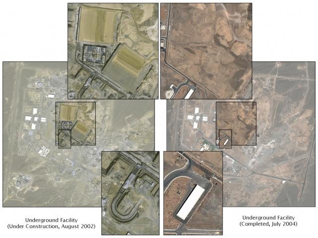
As you can see from the areas that are enlarged, Iran was constructing three very large buildings in August 2002 (upper enlargements) that appear to have been covered with dirt by the time the July 2004 image was taken.
These are believed to be the buildings that will house the centrifuges to enrich uranium.
Similarly, the ramp leading down into the buildings (lower enlargements) has been covered with earth and a small building constructed over the entrance.
Using images from Space Imaging, the Institute for Science and International Security and GlobalSecurity.org have put together short analyses of the Iranian nuclear program that make for an interesting read.
