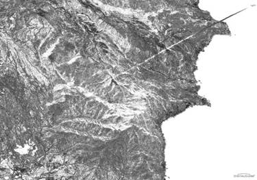
Jan Stupl’s contour of pixel intensity of the U’nha-2 contrail image
Jan Stupl, who is a Science Fellow at Stanford’s CISAC this year and who has done an amazing experimental and theoretical analysis of the US Airborne Laser, produced a very important processed image of the DigitalGlobe/Globalsecurity.org image of the U’nha-2 launch. This has allowed me to add a considerable number of points to the reconstructed trajectory. That in turn clarified a number of points that earlier analyses (that, fortunately, I did not post here) had seemed to indicate that the U’nha-2 was using a rather primitive pitch program with a step function in its thrust vector control algorithm; much like Iraq’s Al Samoud II used. (The pitch program on a guided rocket or missile “kicks” the rocket over from its vertical liftoff orientation and controls the shaping of its powered flight toward its target or orbit insertion point.) In those step pitch programs, the jet vanes of the Al Samoud, for instance, were set at one angle for a certain amount of time and then switched very fast to another angle creating a “step” in the off axis thrust. Its not at all clear that the U’nha-2, which is probably rather fragile, especially in its third stage, could take such kicks. (By the way, I seem to recall that the SCUD-B also uses such step functions in TVC but I can’t seem to find confirmation of that in my records. Do any of you readers know for sure? Documentation of that one way or another would be greatly appreciated.)
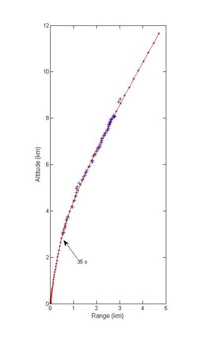
With more points on the trajectory, I can rule those sorts of primitive pitch programs out. The U’nha-2 used a more continuous pitch program perhaps more suited for either vernier or gimbaled engines than jet vanes. To determine this, I fitted an arbitrary pitch program run on a rocket model developed by Ted Postol to the reconstructed trajectory. The fit was free to move the times of the pitch steps as well as the angles of thrust to any point that created the best fit. Perhaps surprisingly, it picked times corresponding to ranges outside the reconstructed trajectory and a continuous linear change in thrust angle inside the reconstructed points. (I’ve pointed out the closest “step” in thrust angle rate at 35 s.)
I actually expected, especially when I had fewer points, that it would get a step in thrust angle corresponding to the “kink” at 1.2 km range. After more work, it turns out that the “kink” corresponds to the points on and to either side of the highest ridge in the image. The altitudes of the points of the terrain at which the contrail is projected onto is important in reconstructing the actual trajectory and any error in that terrain height directly produces errors in the reconstruction. I suspect that the altitudes I found for that peak are somehow approximations (perhaps created by averaging nearby altitudes?) and that is what caused this kink.
I’ve also looked at various types of trajectories that maximize the range of the U’nha-2, what would be called ICBM trajectories. All of these trajectories, independent of whether or not they had the same or shorter burn times for the third stage or even if they had a third stage, were shallower than the reconstructed trajectory and would seem to say that the DPRK flew a space-launch trajectory. However, my program for simulating trajectories is what is known as a “three degree of freedom model” and does not include very important factors such as bending forces on an extended rocket body. I’m hesitant to use such a model in this very important region very close to the launch point to answer such questions.
It’s Patriot’s Day here in New England and I have to run off and see the Boston Marathon run by my house. Happy Patriot’s Day!

Keep up the great work. BTW, not sure if you saw but Secretary Gates was quoted as saying all the intel pointed to a space launch”:
http://blog.wired.com/defense/2009/04/why-gates-kept.html
Not sure if he meant just pre-launch or post launch as well, but it it interesting.
Have you seen the Spaceflight Now article? They seem to have had some kind of briefing. They say smoke puffs at the moment of liftoff and after may indicate attitude control thrusters. The second stage uses a Scud-ER (extended range) “step-throttling” rocket engine. And that the solid propellant third stage failed to separate properly after the second stage finished firing normally.
Actually, Rwendland, I think its going to turn out that the Unha-2 is a lot more advanced than that. But its not my research so Im going to wait until those who have done it release their work.
> until those who have done it release their work.
Any idea when that might happen?
I must say that i don’t think that the “puff of smoke” indicates attitude control thrusters (maybe ok for roll-, but an absolutely awkward placement for pitch- and yaw-control, isn’t it? Can anybody identify small rocket flames at or near the suggested location? No? Also, a small blow-off of nitrous oxide at ignition seems to be quite common for rockets with nitric-acid/NTO-based oxidisers – compare this to the chinese DF-5/CZ-2-series or the russian R-36M/Dnepr-booster).
Instead, i interpret the bright stripes in the brown-black kerosene-film-cooling-layer of the rocket exhaust as an indicator for jet vanes (compare this to similar effects on Scud and Nodong – BTW, i assume that the Eunha-first-stage uses four complete Nodong-engines without common turbopump in a 2.4-2.5m-diametered body; maybe there are two small fins in the I-III-plane).
And “step-throttling” (What exactly do they mean by this? Real step-throttling to reduce acceleration in later burn-phases like on the space shuttle or simply putting too little pressure-gas on the missile for a full-duration-burn, like the Iraqis obviously did on the Al-Hussain H2?) does not really make sense to me, since this will have in either case a negative impact on the overall missile-performance (less than full thrust -> lower mass-flow -> lower chamber pressure, because the geometry can’t be adjusted -> lower Isp -> loss in efficiency!).
> in a 2.4-2.5m-diametered body
Have our image interpreter friends arrived at that as the diameter of the first stage as shown in the various pictures on Eunha-2?
If we accept that the first stage is composed of four separate Nodong engines using differential throttling for steering. Then what is the performance of each of these Nodongs? Do they possess the standard thrust of a regular Nodong (~26 tons) or the souped up thrust of the Safir version (~32 tons). If we assume the regular version then we get a first stage thrust of roughly 104 tons and assuming a GLOW of 80 tons we get an acceleration of 1.3 gees , ceteris paribus with a Safir engine we get a total thrust of 128 tons and an acceleration of 1.6 gees. The video in my opinion seems to lean towards 1.3 gees, thus the regular Nodong engines seem the most likely candidate.
As far as the upper stage; the two alternatives that present themselves are a vacuum optimized short Nodong or an elongated Safir upper stage. If someone can shed light on this it would give us more insight into the respective degree of cross fertilization of the IRI and DPRK programs.
Question; why didn’t the Iranians share the uprated Safir engines with the Koreans? Doing so would have allowed a considerable increase in payload delivery for the Unha-2 carrier. For two programs that are considered so interconnected why do they seem to lack this degree of sharing with respect to the key building block of a space program?
To Allen Thomson:
I can’t speak (or rather write) for all of “our image interpreter friends”, but let me present some of my own conclusions based on the available photo/video-material of the Eunha-launcher.
First of all, i’m measuring an l/d of ~12-13, a diameter-ratio of the second to the first stage of approximately 0.6 and 0.5 third/first stage respectively.
Secondly, the launch tower seems to have still the same dimensions as in the 1998-footage (the only differences i can identify are an additional, fifth catwalk above the others and possibly a lengthened crane arm), so this allows me an estimation of the general dimensions of the new missile compared to the Paektusan-1 of 1998 (1.25m/0.88m diameter, ~23m length); Thus i estimate a length of the Eunha-2 of 29-32m and a first stage diameter in the range of 2.4-2.5m (which would coincidentally also be consistent with four Nodong-engines with an estimated thrust-chamber diameter of 810-820mm; According to my own calculations, that plus additional TVC- and other necessary structural elements would be impossible to fit into a 2.25m DF-3/CSS-2 or MR-UR-100/SS-17/Spanker body). Due to the low resolution of especially the 1998-material available to me, i can’t decide with absolute certainty which diameter is correct, but at the moment i tend to the 2.5m-figure.
The diameter of the second stage seems to be close to 1.5m (remember the rumors about R-27/SSN-6/Serb in North Korea?), while the third stage/payload shroud looks to me like it has the Nodong’s 1.25m-diameter. I can’t make any substantiated statements about the upper stage engines, though. Possibilities might be a Nodong-engine with nozzle-extension for the second and perhaps a similarly modified Scud-engine for the third stage, but up to now, i don’t have any evidence of such a configuration, so this is mere speculation.
Another important question would be the origin of the production-tooling for a missile with these diameters (since, after examining the DPRK on Google Earth, i have difficulties believing that the North Koreans are industrially on the same level as 1. or even 2.world countries – unless they are using their secret holo-projection-device to deceive the satellites…); possible candidates would be the R-14/SS-5/Skean (2.4m), the UR-100N/SS-19/Stiletto (2.5m) and, of course, the R-27/SSN-6/Serb (1.5m) and R-15?/Moksong/Nodong (1.25m).
I’d appreciate others to cross-check my preliminary reconstruction, because if this turns out to be right, then the transfer of old russian (or rather soviet) missile technology to North Korea might be much more extensive than prevously thought!
The diameters seem to be 2.25m, 1.25m and .88m for the first , second and third stages respectively. I think its best practice not to wildly assume linkages with other rocket projects based merely on tankage diameters. I understand that some strongly feel that North Korea and Iran are backward countries with nothing more a few goat collectives but wearing such blinders will only set the stage for strategic surprise.
Azr@el:
Normally, i would agree with you, since such a configuration would only require one new diameter (2.25m aka DF-3/CSS-2 or MR-UR-100/SS-17/Spanker – in contrast to you, i think it is advisable to look out for possible linkages with other missile projects instead of wildly assuming complete indigenous reinvention of something with identical dimensions by someone without documented experience in that sector! BTW, i hope you are aware of the fact that the diameter is the most intricate dimension to change in respect to missile bodies…which makes complete new production-line tooling necessary…).
But your suggested diameters would simply not fit well with photo-measurements: 2.25/1.25/0.88m would result in diameter ratios of ~0.56 and ~0.39 (i’m measuring ~0.60 and ~0.50) and a length of the missile in the range of 27-29m (l/d of 12-13)! Using the launch tower as scaling tool, i get values of 2.3-2.6m for first stage diameter and a length of approximately 29+m (rather 30-31m).
Also, as i wrote before, according to my calculations/estimations, four Nodong-engines might be difficult (probably even impossible if i take additional elements like the thrust frame, the turbopump, jet vane actuators, outer-skin reinforcements etc. into account) to fit into a body with a diameter of less than 2.4m. And i think we can agree on that the exhaust of that missile looks intriguingly like one might expect four clustered Nodong-engines (or Scud-engines, if the size would be right) to look like (including the bright stripes in the film-cooling layer – an incidation of jet vanes in my opinion; BTW, please forget about steering by thrust differential; that might look good on paper, but turns out to be nothing but engineering nightmares in reality – comparably slow in response, complicated and thus unreliable and, what is more, unfortunately less efficient than generally postulated in advance; In case of the Eunha, additional roll-control would be required, and i see no sign of that – no additional flames, no additional rocket engines!).
Considering the thrust level, i must say that i have not yet come to a final conclusion on that one myself; based on my assumed geometry i can deduce a liftoff weight of about 75-90t (your configuration would yield around 60-70t at an average density for launchers with storable propellants), which would be, at the measured liftoff-acceleration of ~1.4g, roughly consistent with a thrust of 108-128t (length measurements of the exhaust-gas-plume are difficult in the available photo/video-material, but generally seem to corroborate something in that range).
This is an interesting discussion that gets to the heart of the two major camps who are trying to understand how technology (in this case missile technology but in the wider discussion any technology) is acquired by a country. I have been totally influenced by studies of the diffusion of civilian technologies that definitely show the best way of acquiring technology that is new to a country is to lease the manufacturing capability from a company that already has it. This does not, at least in my mind, imply anything backward about the country that is leasing the technology. History has simply shown this is the best way of gaining that knowledge. So when I say I suspect that a country like North Korea or Iran is using technology it obtained from another country, I am definitely not saying that they are a bunch of goat herders. Far from it. They are simply acquiring technology in the fastest way and assimilating it in the most complete way possible.
Having said that, I agree that the second stage of U’nha-2 is most likely an SSN-6 and that the third stage looks remarkably like the second stage of the Safir. It again would be interesting to know what the 2006 Taepodong-2 looked like to see which of these stages, if any, were tested then.
But there is one thing I am still uncomfortable with: the number of engines on the first stage. I definitely see two and can hypothesize that there are four which are simply aligned so that you don’t see them. But has anyone better proof than that there are four?
Something completely different inbetween, Geoff:
Considering the pitchover-program of the Scud, i think this is likely using a step-function, albeit a rather smooth/optimized one (compared to it’s predecessors); I haven’t found anything 100% conclusive on that issue yet, though (it would be very interesting to dissect a 1SB15 “timing device” and a 1SB16 “switching box” of an 8K14, but unfortunately, i haven’t got my hands on one of these yet).
But i am sure that the Aggregat-4/V-2 used exactly such a sort of pitchover-program, and the main elements of that guidance system were rather similar as on the Scud. According to Reisig, it was 0°/sec in flight second 0-4, 1.8°/sec up to sec 11, 1.2°/sec up to sec 14, 0.9°/sec up to sec 30, 0.8°/sec up to sec 48 and 0.5°/sec up to sec 52; after that up to the maximum burn-time of ~63sec, the final trajectory-angle of 43° was held (this was the designated time-window for cutoff).
BTW, i’d be interested in more extensive information on the Al-Samoud’s pitchover-program; Was this the same as on Al-Samud 2 (the UNMOVIC-compendium is a bit inexplicit on this issue)?
P.S.: Considering the number of engines, i can’t be sure either – but four Nodong-engines might be somewhat consistent with the geometry/liftoff-weight/liftoff-thrust of the Eunha-2 reconstructed by me, two are almost certainly too little for the observed liftoff-acceleration. And i agree, the complete lack of photographic evidence of the 2006-launch is very dissatisfying!
I believe both the Iranian and North Korean programs have benefited from outside assistance to their theater ballistic missile programs, but I fail to see any outside assistance by any power to their intercontineal or spacefaring aspirations. The three most oft cited would be proliferators are Russia, the PRC and India. Not one of which has an incentive to empower the DPRK or IRI with the means to reach out and touch anyone across continental distances. In fact it can be soundly argued that strides forward by both the DPRK and IRI in that direction directly and indirectly impact all three would be proliferators in a negative manner.
The DPRK acquired scuds on the black market from Egypt and reverse engineered them. Iran acquired the kimchi flavoured scuds from North Korea. North Korea went on with the assistance of Google and no doubt a few consultants to improve upon their scud designs and pass the savings on to the Iranians. So far no one has ever produced evidence that the Sino-Indo-Ruski-anyone-else axis has ever transferred missiles or tooling to either. But hypothetically assume someone had: wouldn’t their respective programs look completely different.
Would the Iranian program look so chaotic and take so long if it had access to a proven design? Would anyone have seriously tried to cobble together the TD-1, with all of it’s inherent mistakes, if they had access to say the SERB? It stretches the level of credulity to imagine that a program with access to udmh/nto 26t sl Isayev OKB 4D10 would still be playing around with NoDong engines reacting less energetic propellant.
First of all, i don’t buy into the myth that the DPRK “reverse-engineered” the Scud-B via a few specimens acquired from Egypt (in some of the current legends, this is even the Scud-A – a missile never exported to Egypt – and wonderously gets “reverse engineered” to the last inch by the North Koreans without any documentation or previous experience on that sector into the internally completely different Scud-B, and later even the Scud-C…and the produced missiles even more wonderously later turn out to work perfectly without any credible flight-test program! Hey, i’m trying hard to avoid the expression “ridiculous” in this context, but that is really difficult…).
Everybody with even only the slightest insight into industrial production processes will tell you that something like this will only be possible if you have the same or a higher level of industrial sophistication than the one you’re trying to copy (and particularly not without an extensive testing program!) – and then, the resulting product will either be of considerably less quality than the original, or it will have more the character of “stolen engineering ideas” instead of an outright copy (aka other dimensions, different materials, unlike engineering solutions in certain aspects etc.). Believe me, even basic things like screws can be quite challenging if you don’t have access to adequate production capability (think e.g. of millimeters versus inches!), the right material and/or the original documentation. And we’re talking about MUCH more complicated things here…
This smells more like preproduced missiles exported by Russia to the DPRK to me (although this has always been denied by the Russians – like the export of 9M714/SS-23/Spider to East Germany, Czechoslovakia or Bulgaria…), later backed up by helping them establish a “license-production” capability for the R-17E/SS-1c/Scud-B, followed by the 9M77/SS-1d/Scud-C and then R-15?/Moksong/Nodong-A (both more or less finished designs never adopted by the red army/navy) modified for use with conventional warheads (Russia obviously had scruples to export nuclear warheads – even warsaw pact forces had to rely on the USSR “lending” them the warheads for their missiles).
These missiles enabled the DPRK to hit 1.) south korean major cities 2.) all of South Korea and 3.) Japan.
It looks to me as if the Russians weren’t daring enough to export full-fledged missile-technology with ranges to threaten the remaining strategic target of the DPRK, the USA, though; This forced the North Koreans to “make-do” with the components already available to them, the result was the Paektusan/Taepodong-A; Since that “cobbled-together” missile was obviously disappointing (especially to the potential export customer Iran – who apparently started an independent development/procurement effort leading to the Ghadr-1/Nodong-B and ultimately to the Safir IRILV), new more powerful components (unused 1.5m and 2.4 or 2.5m production tooling, probably professional engineering expertise and who-knows-what-else) were acquired (most likely via the usual path: Russia and/or other states of the former Soviet Union; minor components like e.g. jet vane actuators or all-purpose machine-tools might also be of chinese or even “western” provinience). The result of this effort is obviously the Eunha/Taepodong-B. And i don’t have any idea how all of this was financed by a country with difficulties feeding its own population…
BTW, i also don’t think the North Koreans/Iranians have access to a complete Isayev 4D10 – but that engine block consisted of two distinct components: a fixed ~22t closed-cycle main chamber (which i’d mark as improbable to be available to these countries) and a fully gimbaled ~3t two-chamber open-cycle vernier-engine (obviously used in slightly modified form on the upper stage of the iranian Safir).
Considering the “chaotic and take so long” part: simply compare this to the missile programs of Germany, the USSR, the USA, China, France or India – you might find out that both characteristics are quite common…