click on the image for a larger version
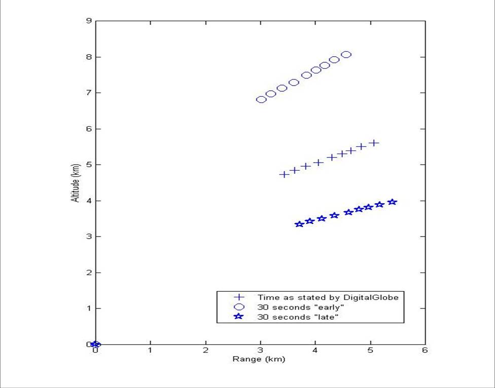
The amazing satellite image by DigitalGlobe and presented by GlobalSecurity.org of the Unha-2 in flight can be used to determine the portion of the powered trajectory as it crosses those altitudes where contrails are normally produced. The graph above, which I calculated from that image and the position of the worldview-1 satellite at the time the image was taken, shows some of the points that any simulation of the rocket will have to fit. This, together with the splash down zones will add significant constraints to certainly the first stage. Some wonk-readers have wondered about both the direction and position of the observed contrail as projected against the Earth’s surface. This can be simply explained by the oblique viewing angle of the satellite (which had a latitude of 33 N degrees and a longitude of 126.6 degrees E and an altitude of 489.7 km) at the time the image was take and the fact that the rocket itself was over 4 km above the surface of the Earth.

Can you send me the X/Y coordinates for range vs altitude?
The coordinates you’ve deduced are very linear in R/Alt space, with the Y intercept (R=0) at an altitude of about 1.2 km which ought to tell something about the pitch maneuver. To judge from the TV it started reasonably low to the ground. At 5 km down range it’s about 2.8 km up for an ascent angle of about 29.5 degrees. Seems reasonable; I would expect it to pitch farther toward the horizontal at greater altitude.
Come to think of it, I might have expected it to go higher before pitching to reduce atmospheric drag.
-p
And here we are, right as i expected – “depressed trajectory” and “maneuvering missile”.
I still like my own idea with the recon-jet-aircraft better, but well…
Geoff, do you have a timing at hand when exactly the sat-image was taken? This could help to determine if the image could have been captured at the presumed launch-time (and/or if globalsecurity’s 102-minutes-before-splashdown-figure is correct).